Frigg Fjord

Last updated
Frigg Fjord
Operational Navigation Chart A-5, 3rd edition.jpg
Map of Northern Ellesmere Island and far Northern Greenland.
Greenland edcp relief location map.jpg
Red pog.svg
Frigg Fjord
Location in Greenland
Location Arctic
Coordinates 83°7′N33°0′W / 83.117°N 33.000°W / 83.117; -33.000
Ocean/sea sources Frederick E. Hyde Fjord
Wandel Sea
Basin  countries Greenland
Max. length19 km (12 mi)
Max. width7 km (4.3 mi)
SettlementsNone

Frigg Fjord (Danish : Friggs Fjord) is a fjord in Peary Land, far northern Greenland. [1]

Contents

The archaeological remains in the northern shore and at the head of this fjord belong to the northernmost human settlements in human history. Further ruins slightly to the north at Cape Bridgman have been found, likely as a short-term expedition from the Frigg Fjord settlement. [2]

History

The area around the shores of Frigg Fjord was inhabited by the Independence I culture and later the Independence II culture until about 2,400 years ago. These inhabitants were people dependent on hunting muskoxen for survival and they lived a great part of the year in complete darkness. The ruins were found in the first half of the 20th century. The main sites are the Adam C. Knuth site, Qissivik and the Whale Terraces. [2]

Since all other fjords in Northern Peary Land are frozen even in the summer, Frigg Fjord was identified as one of the few places where a seaplane can land in the northern part of Peary Land by the members of a 1953 geological expedition. After landing successfully with their plane in the unfrozen surface of the head of the fjord, they made a south–north crossing of the Roosevelt Range through the Polkorridoren pass to Sands Fjord. [3]

Geography

Frigg Fjord is an offshoot on the northern shore of Frederick E. Hyde Fjord located 95 km (59 mi) from Cape John Flagler, at the fjord entrance. The fjord is roughly oriented in a NW/SE direction. There are two small islands near the head and there is no glacier discharging in the fjord. Freja Fjord has its mouth in the opposite side of Frederick E. Hyde Fjord. [4]

Unusually for the latitude, the head area of Frigg Fjord is not frozen in the summer. When Lauge Koch saw a sector of this area from the air in 1938, he named it Drivhuset, meaning greenhouse, because he thought it was covered with vegetation, but it turned out to be an extensive, barren delta terrain. [5] [3]

Bibliography

See also

Related Research Articles

<span class="mw-page-title-main">Peary Land</span> Peninsula in northern Greenland

Peary Land is a peninsula in northern Greenland, extending into the Arctic Ocean. It reaches from Victoria Fjord in the west to Independence Fjord in the south and southeast, and to the Arctic Ocean in the north, with Cape Morris Jesup, the northernmost point of Greenland's mainland, and Cape Bridgman in the northeast.

<span class="mw-page-title-main">Independence I culture</span> Paleo-Eskimo culture of northern Greenland

Independence I was a culture of Paleo-Eskimos who lived in northern Greenland and the Canadian Arctic between 2400 and 1900 BC. There has been much debate among scholars on when Independence I culture disappeared, and, therefore, there is a margin of uncertainty with the dates.

<span class="mw-page-title-main">Independence II culture</span> Paleo-Eskimo culture

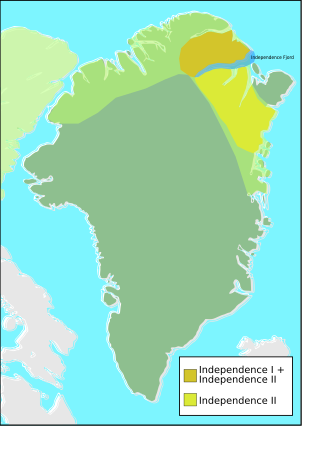
Independence II was a Paleo-Eskimo culture that flourished in northern and northeastern Greenland from around 700 to 80 BC, north and south of the Independence Fjord. The Independence II culture existed in roughly the same areas of Greenland as the Independence I culture, which became extinct six centuries before the beginning of Independence II.

Brønlundhus, on some maps also Brønlundfjord, is a former research station and radio station located on the western shore of Jørgen Brønlund Fjord in southern Peary Land, in northern Greenland. It is named after Greenlandic Arctic researcher Jørgen Brønlund, or after the namesake fjord on which it is located. It is close to the mouth of Jørgen Brønlund Fjord where it opens into Independence Fjord.

Count Eigil Knuth was a Danish explorer, archaeologist, sculptor and writer. He is referred to as the Nestor of Danish polar explorers. His archaeological investigations were made in Peary Land and adjacent areas of High Arctic Greenland. Knuth was made a Knight of the Dannebrog.

<span class="mw-page-title-main">Frederick E. Hyde Fjord</span>

Frederick E. Hyde Fjord is a fjord in Peary Land, far northern Greenland.

Deltaterrasserne is a pre-Inuit occupation archaeological site located near the head of Jørgen Brønlund Fjord on the Peary Land peninsula in northern Greenland. It is one of the largest archaeological sites in Peary Land, and was discovered in September 1948 by the Danish explorer and archaeologist Eigil Knuth during the second summer of the Danish Pearyland Expedition. Occupied during the period of 2,050–1,750 BC, the site contains features of Independence I and Independence II cultures.

<span class="mw-page-title-main">Sermilik</span>

Sermilik is a fjord in eastern Greenland. It is part of the Sermersooq municipality.

<span class="mw-page-title-main">Umivik Bay</span>

Umivik Bay, also known as Umiivik and Umerik, is a bay in King Frederick VI Coast, southeastern Greenland. It is part of the Sermersooq municipality.

<span class="mw-page-title-main">Freja Fjord</span>

Freja Fjord is a fjord in Peary Land, far northern Greenland.

<span class="mw-page-title-main">Cape Bridgman</span> Headland in northeast Greenland

Cape Bridgman is a headland in the Wandel Sea, Arctic Ocean, northeast Greenland.

<span class="mw-page-title-main">Sands Fjord</span> Fjord in northern Greenland

Sands Fjord is a fjord in Peary Land, northern Greenland. To the north, the fjord opens into the Lincoln Sea of the Arctic Ocean. Administratively, it belongs to the Northeast Greenland National Park.

<span class="mw-page-title-main">Nordkrone</span> Mountain in Greenland

Nordkrone is a mountainous area in Peary Land, Northern Greenland. Administratively it is part of the Northeast Greenland National Park.

<span class="mw-page-title-main">Roosevelt Range</span>

The Roosevelt Range or Roosevelt Mountains is a mountain range in Northern Greenland. Administratively this range is part of the Northeast Greenland National Park. Its highest peak is the highest point in Peary Land.

<span class="mw-page-title-main">Johannes V. Jensen Land</span> Region in Northeast Greenland National Park, Greenland

Johannes V. Jensen Land is an area in Peary Land, Northern Greenland. Administratively it lies in the Northeast Greenland National Park zone. The area is remote and currently uninhabited.

<span class="mw-page-title-main">Cape Harald Moltke</span> Headland in Peary Land, North Greenland

Cape Harald Moltke is a headland in Peary Land, North Greenland. Administratively it is part of the Northeast Greenland National Park.

<span class="mw-page-title-main">Nansen Land</span> Peninsula of Greenland

Nansen Land is a peninsula in far northwestern Greenland. It is a part of the Northeast Greenland National Park.

<span class="mw-page-title-main">Wyckoff Land</span>

Wyckoff Land is an area or peninsula in Peary Land, Northern Greenland.

<span class="mw-page-title-main">Herluf Trolle Land</span>

Herluf Trolle Land is an area in Peary Land, North Greenland. Administratively it is part of the Northeast Greenland National Park.

References

  1. "Frigg Fjord". Mapcarta. Retrieved 17 June 2019.
  2. 1 2 Bjarne Grønnow, Jens Fog Jensen: The Northernmost Ruins of the Globe. Eigil Knuth’s Archaeological Investigations in Peary Land and Adjacent Areas of High Arctic Greenland (= Man & Society. Vol. 29). Museum Tusculanums Forlag, Københavns Universitet, Copenhagen 2003, ISBN   978-87-635-3065-1 , 978-8763512626 pp. 219–237
  3. 1 2 "Crossing North Peary Land in Summer 1953" (PDF). Archived from the original (PDF) on 2020-07-05. Retrieved 2019-06-17.
  4. Prostar Sailing Directions 2005 Greenland and Iceland Enroute, p. 130
  5. Geografisk Tidsskrift, Bind 50 (1950) Dansk Pearyland Ekspedition. Sidste års meteorologi og topografisk overblik