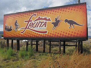
Fruita is a home rule municipality located in western Mesa County, Colorado, United States. The city population was 13,395 at the 2020 United States Census. Fruita is a part of the Grand Junction, CO Metropolitan Statistical Area and lies within the Grand Valley. The geography is identified by the bordering Colorado River on the southern edge of the town, the Uncompahgre Plateau known for its pinyon-juniper landscape, and the Book Cliffs range on the northern edge of the Grand Valley. Originally home to the Ute people, farmers settled the town after founder William Pabor in 1884. Ten years later, Fruita was incorporated.

Bicknell is a town along State Route 24 in Wayne County, Utah, United States. As of the 2010 census, the town population was 327.

Torrey is a town located on State Route 24 in Wayne County, Utah, United States, 8 miles (13 km) from Capitol Reef National Park. As of the 2010 census, the town had a population of 182.

Capitol Reef National Park is an American national park in south-central Utah. The park is approximately 60 miles (100 km) long on its north–south axis and just 6 miles (10 km) wide on average. The park was established in 1971 to preserve 241,904 acres of desert landscape and is open all year, with May through September being the highest visitation months.

Hanksville is a small town in Wayne County, Utah, United States, at the junction of State Routes 24 and 95. The population was 219 at the 2010 census.

The Waterpocket Fold is a geologic landform that extends from southern Wayne through Garfield and ending in northern Kane counties of southern Utah, United States. The geologic structure, formed during the Laramide orogeny, is a south-southeast trending fold in which the east side is dropped relative to the west side. This monoclinal fold extends for nearly 100 miles (160 km) in the semi-arid plateau of the central part of the state. The structure defines the Capitol Reef National Park in southern Utah.

Teasdale is a census-designated place in western Wayne County, Utah, United States, between the Dixie and Fishlake National Forests and near Capitol Reef National Park. The population was 191 at the 2010 census. Teasdale lies along local roads south of State Route 24, southeast of the town of Loa, the county seat of Wayne County. Teasdale has a post office with the ZIP code 84773.

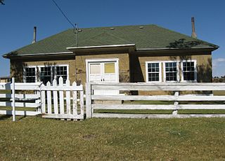
The Fruita Schoolhouse is a historic school building located in Fruita, Utah, United States.

The Fruita Rural Historic District is a historic district in the Capitol Reef National Park in Wayne County, Utah, United States, that is listed on the National Register of Historic Places.
Grover is an unincorporated community in southwestern Wayne County, Utah, United States. Originally known as Carcass Creek, Grover is a small ranching community off the county's main recreational corridor.

State Route 24 (SR-24) is a state highway in south central Utah which runs south from Salina through Sevier County then east through Wayne County and north east through Emery County. At a total of 163.294 miles, it is the longest contiguous state route in Utah. A portion of the highway has been designated the Capitol Reef Scenic Byway as part of the Utah Scenic Byways program.

The Elijah Cutler Behunin Cabin was built to house Elijah Cutler Behunin's family in 1883–84 in what is now Capitol Reef National Park in Wayne County, Utah, United States.

The Civilian Conservation Corps Powder Magazine in Capitol Reef National Park, Utah, was used in the 1930s to store explosives for use by Civilian Conservation Corps laborers in the construction of improvements to the park. Much of the CCC's work in the park involved the quarrying of sandstone blocks and slabs, which required explosives. The magazine was built about 1938 in association with CCC Camp NM-2, later called NP-6, located to the west of Fruita at Chimney Rock. The Fruita ranger station and the powder magazine are the only structures remaining from the CCC tenure in the park.

The Castle is a 6,387-foot (1,947 m) summit in Capitol Reef National Park in Wayne County, Utah, United States. This iconic landmark is situated 0.5 mi (0.80 km) immediately north of the park's visitor center, towering nearly 800 feet (240 m) above the center and Utah State Route 24. Precipitation runoff from this feature is drained by tributaries of the Fremont River.

Chimney Rock is a 6,420-foot (1,960 m) summit in Capitol Reef National Park in Wayne County, Utah, United States. This landmark is situated 2.5 mi (4.0 km) northwest of the park's visitor center, towering over 300 feet (91 m) above Utah State Route 24. Chimney Rock is also 2.5 mi (4.0 km) northwest of another of the park's landmarks, The Castle. Precipitation runoff from this feature ends up in the Colorado River drainage basin. The Chimney Rock Trail is a 3.5-mile loop trail that takes hikers to a view of Chimney Rock from above Mummy Cliffs.
Ferns Nipple is a 7,065-foot (2,153-meter) elevation summit located in Capitol Reef National Park, in Wayne County of Utah, United States. This iconic landmark is situated four miles (6.4 km) southeast of the park's visitor center. Precipitation runoff from this feature is drained by tributaries of the Fremont River, which in turn is within the Colorado River drainage basin. Folklore attributes this geological feature's naming to outlaw Butch Cassidy and his favored girlfriend named Fern.
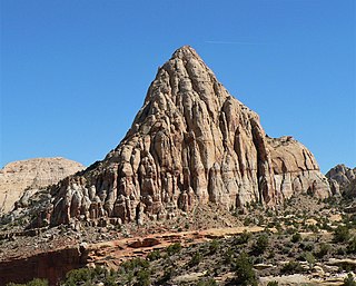
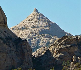
Pectols Pyramid is a 6,211-foot (1,893-meter) elevation summit located in Capitol Reef National Park, in Wayne County of Utah, United States. This iconic landmark is situated two miles (3.2 km) southeast of the park's visitor center, one mile (1.6 km) south of Navajo Dome, and 0.5 mi (0.80 km) southwest of Capitol Dome. Precipitation runoff from this feature is drained by the Fremont River, which in turn is within the Colorado River drainage basin. This geological feature's name honors Ephraim Portman Pectol (1875–1947), booster and founder of what would become Capitol Reef National Monument in 1937.

Temple of the Sun is a 5,822-foot (1,775-meter) elevation summit located in Capitol Reef National Park, in Wayne County of Utah, United States. This remote, iconic monolith is situated 12.5 mi (20.1 km) north-northeast of the park's visitor center, and 0.37 mi (0.60 km) north of Temple of the Moon, in the Middle Desert of the park's North District. Cathedral Valley was so named in 1945 by Charles Kelly, first superintendent of Capitol Reef National Monument, because the valley's sandstone monoliths reminded early explorers of ornate, Gothic cathedrals, with fluted walls, alcoves, and pinnacles. The free-standing Temple of the Sun towers over 400 feet above its surrounding terrain, which is within the Fremont River drainage basin. John C. Frémont's 1853 expedition passed through Cathedral Valley.

Cathedral Mountain is a 6,924-foot (2,110 m) summit located in Capitol Reef National Park, in Wayne County of Utah, United States.

Hickman Natural Bridge is a 125-foot-tall natural bridge located in Capitol Reef National Park, Wayne County, Utah, United States. The formation spans 133 feet, making it one of the largest rock spans in the park.