Utah is a landlocked state in the Mountain West subregion of the Western United States. It is bordered to its east by Colorado, to its northeast by Wyoming, to its north by Idaho, to its south by Arizona, and to its west by Nevada. Utah also touches a corner of New Mexico in the southeast. Of the fifty U.S. states, Utah is the 13th-largest by area; with a population over three million, it is the 30th-most-populous and 11th-least-densely populated. Urban development is mostly concentrated in two areas: the Wasatch Front in the north-central part of the state, which is home to roughly two-thirds of the population and includes the capital city, Salt Lake City; and Washington County in the southwest, with more than 180,000 residents. Most of the western half of Utah lies in the Great Basin.

Salt Lake City, often shortened to Salt Lake or SLC, is the capital and most populous city of Utah, United States. It is the seat of Salt Lake County, the most populous county in Utah. With a population of 200,133 in 2020, it is the 117th most populous city in the United States, the city is the core of the Salt Lake City metropolitan area, which had a population of 1,257,936 at the 2020 census. Salt Lake City is further situated within a larger metropolis known as the Salt Lake City–Ogden–Provo Combined Statistical Area, a corridor of contiguous urban and suburban development stretched along a 120-mile (190 km) segment of the Wasatch Front, comprising a population of 2,746,164, making it the 22nd largest in the nation. It is also the central core of the larger of only two major urban areas located within the Great Basin.

Juab County is a county in western Utah, United States. As of the 2020 United States Census, the population was 11,786. Its county seat and largest city is Nephi.

Salt Lake County is located in the U.S. state of Utah. As of the 2020 United States census, the population was 1,185,238, making it the most populous county in Utah. Its county seat and largest city is Salt Lake City, the state capital. The county was created in 1850. Salt Lake County is the 37th most populated county in the United States and is one of four counties in the Rocky Mountains to make it into the top 100. Salt Lake County has been the only county of the first class in Utah – under the Utah Code is a county with a population of 700,000 or greater. Although, Utah County directly to the south has recently reached this threshold.

Sevier County is a county in Utah, United States. As of the 2020 United States Census, the population was 21,522. Its county seat and largest city is Richfield.

Wayne County is a county in the U.S. state of Utah. As of the 2020 census, the population was 2,486, making it the fourth-least populous county in Utah. Its county seat is Loa.

Magna is a metro township in Salt Lake County, Utah, United States. The current population of the township stands at 29,251 according to the 2020 census, a 10.4% increase over 26,505 in 2010.

Millcreek is a city in Salt Lake County, Utah, United States, and is part of the Salt Lake City Metropolitan Statistical Area. The population as of the 2020 Census was 63,380. Prior to its incorporation on December 28, 2016, Millcreek was a census-designated place (CDP) and township.

Murray is a city situated on the Wasatch Front in the core of Salt Lake Valley in the U.S. state of Utah. Named for territorial governor Eli Murray, it is the state's fourteenth largest city. According to the 2020 census, Murray had a population of 50,637. Murray shares borders with Taylorsville, Holladay, South Salt Lake and West Jordan, Utah. Once teeming with heavy industry, Murray's industrial sector now has little trace and has been replaced by major mercantile sectors. Known for its central location in Salt Lake County, Murray has been called the Hub of Salt Lake County. Unlike most of its neighboring communities, Murray operates its own police, fire, power, water, library, and parks and recreation departments and has its own school district. While maintaining many of its own services, Murray has one of the lowest city tax rates in the state.

South Jordan is a city in south central Salt Lake County, Utah, United States, 18 miles (29 km) south of Salt Lake City. Part of the Salt Lake City metropolitan area, the city lies in the Salt Lake Valley along the banks of the Jordan River between the 10,000-foot (3,000 m) Oquirrh Mountains and the 11,000-foot (3,400 m) Wasatch Mountains. The city has 3.5 miles (5.6 km) of the Jordan River Parkway that contains fishing ponds, trails, parks, and natural habitats. The Salt Lake County fair grounds and equestrian park, 67-acre (27 ha) Oquirrh Lake, and 37 public parks are located inside the city. As of 2020, there were 77,487 people in South Jordan.

South Salt Lake is a city in Salt Lake County, Utah, United States and is part of the Salt Lake City Metropolitan Statistical Area. The population was 23,617 at the 2010 census.
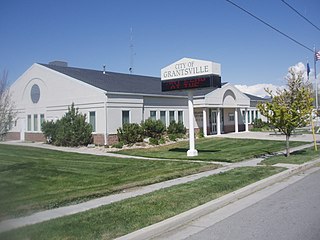
Grantsville is the second most populous city in Tooele County, Utah, United States. It is part of the Salt Lake City, Utah Metropolitan Statistical Area. The population was 12,617 at the 2020 census. The city has grown slowly and steadily throughout most of its existence, but rapid increases in growth occurred during the 1970s, 1990s, and 2010s. Recent rapid growth has been attributed to being close to Salt Lake City, small town community feel, lower housing costs than Salt Lake County, the nearby Deseret Peak recreational center, the Utah Motorsports Campus raceway, and the newly built Wal-Mart distribution center located just outside the city. It is quickly becoming a bedroom community for commuters into the Salt Lake Valley.
Pleasant Grove, originally named Battle Creek, is a city in Utah County, Utah, United States, known as "Utah's City of Trees". It is part of the Provo–Orem Metropolitan Statistical Area. The population was 37,726 at the 2020 Census.
Heber City is a city and county seat of Wasatch County, Utah. The population was 16,856 as of the 2020 United States census. The city is located 43 miles southeast of Salt Lake City.

Bicknell is a town along State Route 24 in Wayne County, Utah, United States. As of the 2010 census, the town population was 327.

Torrey is a town located on State Route 24 in Wayne County, Utah, United States, 8 miles (13 km) from Capitol Reef National Park. As of the 2010 census, the town had a population of 182.

Draper is a city in Salt Lake and Utah counties in the U.S. state of Utah, about 20 miles (32 km) south of Salt Lake City along the Wasatch Front. As of the 2020 census, the population is 51,017, up from 7,143 in 1990.

The Fundamentalist Church of Jesus Christ of Latter-Day Saints is a religious sect of the fundamentalist Mormon denominations whose members practice polygamy. It is estimated that 6,000 to 10,000 members reside within the congregate sister cities of Hildale, Utah and Colorado City, Arizona (raided); Eldorado, Texas (raided); Westcliffe, Colorado; Mancos, Colorado; Creston and Bountiful, British Columbia (sold); and Pringle, South Dakota (sold).

Teasdale is a census-designated place in western Wayne County, Utah, United States, between the Dixie and Fishlake National Forests and near Capitol Reef National Park. The population was 191 at the 2010 census. Teasdale lies along local roads south of State Route 24, southeast of the town of Loa, the county seat of Wayne County. Teasdale has a post office with the ZIP code 84773.
Hebron is a ghost town on Shoal Creek in Washington County in southwestern Utah, United States. Hebron was inhabited from 1862 until 1902, when the already-declining town was mostly destroyed by an earthquake. The present-day city of Enterprise, 6 miles (9.7 km) to the east, was settled largely by people leaving Hebron.