
Prairie County is in the Central Arkansas region of the U.S. state of Arkansas. The county is named for the Grand Prairie, a subregion of the Arkansas Delta known for rice cultivation and aquaculture that runs through the county. Created as Arkansas's 54th county in 1846, Prairie County is home to four incorporated towns, including DeValls Bluff, the southern district county seat, and two incorporated cities, including Des Arc, the northern district county seat. The county is also the site of numerous unincorporated communities and ghost towns. Occupying 676 square miles (175,000 ha), Prairie County is the median-sized county in Arkansas. As of the 2020 Census, the county's population was 8,282. Based on population, the county is the ninth-smallest county of the 75 in Arkansas.

Lonoke County is located in the Central Arkansas region of the U.S. state of Arkansas. As of the 2020 census, the population was 74,015, making it the 10th-most populous of Arkansas's 75 counties. The county seat is Lonoke and largest city is Cabot. Included in the Central Arkansas metropolitan area, with Little Rock as the principal city, it is an alcohol prohibition or dry county.

Cabot is the largest city in Lonoke County, Arkansas, United States, and a suburb of Little Rock. As of the 2010 census, the population of the city was 23,776, and in 2019 the population was an estimated 26,352, ranking it as the state's 19th largest city, behind Jacksonville. It is part of the Little Rock–North Little Rock–Conway Metropolitan Statistical Area.

Carlisle is a city in Lonoke County, Arkansas, United States. It is the easternmost municipality within the Little Rock–North Little Rock–Conway Metropolitan Statistical Area. Carlisle was incorporated in 1878. As of the 2010 census it had a population of 2,214.
Coy is a town in southern Lonoke County, Arkansas, United States. The population was 96 at the 2010 census, making it the smallest incorporated community within the Little Rock–North Little Rock–Conway Metropolitan Statistical Area, as well as one of the smallest in the state.

Keo is a town in southwest Lonoke County, Arkansas, United States. The population was 256 at the 2010 census. It is part of the Little Rock–North Little Rock–Conway Metropolitan Statistical Area.

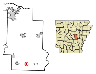
Lonoke is the second most populous city in Lonoke County, Arkansas, United States, and serves as its county seat. According to 2010 United States Census, the population of the city is 4,245. It is part of the Little Rock–North Little Rock–Conway Metropolitan Statistical Area.
Scott is an unincorporated community and census-designated place (CDP) in Lonoke and Pulaski counties in the central part of the U.S. state of Arkansas. Per the 2020 census, the population was 97. It is part of the Little Rock–North Little Rock–Conway Metropolitan Statistical Area.
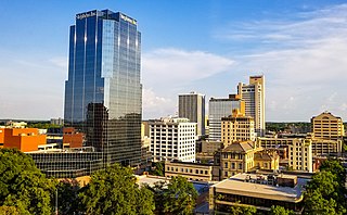
Central Arkansas, also known as the Little Rock metro, designated by the United States Office of Management and Budget as the Little Rock-North Little Rock-Conway Metropolitan Statistical Area, is the most populous metro area in the U.S. state of Arkansas. With an estimated 2020 population of 748,031, it is the most populated area in Arkansas. Located at the convergence of Arkansas's other geographic regions, the region's central location make Central Arkansas an important population, economic, education, and political center in Arkansas and the South. Little Rock is the state's capital and largest city, and the city is also home to two Fortune 500 companies, Arkansas Children's Hospital, and University of Arkansas for Medical Sciences (UAMS).
Romance is an unincorporated community in west-central White County, Arkansas, United States. The community is located approximately halfway between the town of Rose Bud to the north, and the unincorporated community of El Paso to the south. Alternately, the community is about 16 miles (26 km) northwest of Beebe, and less than 5 miles (8 km) east of Mount Vernon.

Highway 319 is a designation for two state highways in central Arkansas. The main segment runs 18.01 miles (28.98 km) from AR 38 in Ward to AR 107 south of Vilonia. A short segment runs 1.65 miles (2.66 km) from Cadron Settlement Park to US 64 in Conway.

Highway 294 is an east–west highway in central Arkansas. Its western terminus is at an intersection with AR 161 in the city of Jacksonville. Its eastern terminus is at an intersection with AR 15 and AR 89 in the unincorporated community of Furlow.

Highway 89 is a highway in the central part of the U.S. state of Arkansas.

Highway 321 is a designation for two north–south state highways in central Arkansas. One route of 11.20 miles (18.02 km) runs from Highway 5/Highway 367 in Cabot north to Highway 38 east of Austin. A second route of 3.79 miles (6.10 km) begins at AR 31 north of Beebe and runs north to Highway 267.

Interstate 40 (I-40) is an east–west Interstate Highway that has a 284.69-mile (458.16 km) section in the U.S. state of Arkansas, connecting Oklahoma to Tennessee. The route enters Arkansas from the west just north of the Arkansas River near Dora. It travels eastward across the northern portion of the state, connecting the cities of Fort Smith, Clarksville, Russellville, Morrilton, Conway, North Little Rock, Forrest City, and West Memphis. I-40 continues into Tennessee, heading through Memphis. The highway has major junctions with I-540 at Van Buren, I-49 at Alma, I-30 in North Little Rock, and I-55 to Blytheville.

Arkansas Highway 15 is the designation for two state highways in Arkansas. The northern segment of 34.45 miles (55.44 km) runs from Altheimer north across Interstate 40 to Furlow. The southern segment of 21.10 miles (33.96 km) is entirely in Union County, and runs from Louisiana Highway 161 north to U.S. Route 82 in El Dorado.
Woodlawn is an unincorporated community in Lonoke County, Arkansas, United States. Woodlawn is located on Arkansas Highway 31, 9.5 miles (15.3 km) north of Lonoke.

Arkansas Highway 236 is an east–west state highway in Lonoke County. The route of 12.51 miles (20.13 km) connects Highway 89 and Highway 13 including a concurrency with Highway 31.
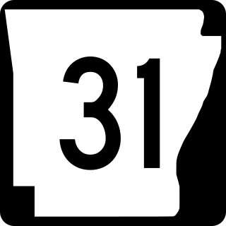
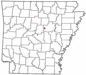
Highway 31 is a north–south state highway in Central Arkansas. The route of 75.34 miles (121.25 km) runs from U.S. Route 79B (US 79B) near Pine Bluff north across US 165, US 70, Interstate 40 (I-40) and US 64/US 67/US 167 before terminating at Highway 5 near Romance.
Tomberlin is an unincorporated community in Indian Bayou Township, Lonoke County, Arkansas, United States. It is located along Highway 31 at an intersection with Tar Bottom Road. Just north of Tomberlin is the Walls Farm Barn and Corn Crib, listed on the National Register of Historic Places.


