Fyfield Road

Last updated

View north along Fyfield Road from the junction with Crick Road. Fyfield Road, Oxford.JPG
View north along Fyfield Road from the junction with Crick Road.
The historian and philosopher R. G. Collingwood, who lived at 5 Fyfield Road. Robin G. Collingwood.jpg
The historian and philosopher R. G. Collingwood, who lived at 5 Fyfield Road.

Fyfield Road is a residential road in North Oxford, England, on the Norham Manor estate. [1]

Contents

At the northern end of the road is a junction with Norham Road and at the southern end is a junction with Norham Gardens, was the University Parks opposite. Halfway along the road, Crick Road leads west to Bradmore Road. To the east is Lady Margaret Hall, one of the colleges of Oxford University. [2] Fyfield Lodge is located at 13 Fyfield Road, more recently divided into five flats. [3]

History and residents

The Norham Manor estate where Fyfield Road is located was originally owned by St John's College, Oxford. The name of the road was taken from Fyfield in Berkshire (now in Oxfordshire), where the college held the manor. Houses in the road were first leased by the college between 1878 and 1887. [1] They were designed by Frederick Codd (Nos 1, 13, and 14), William Wilkinson (Nos 2–4), and Pike & Messenger (Nos 5–12). The houses are in the traditional North Oxford Victorian style of brick construction. [4]

R. G. Collingwood (1889–1943), philosopher, historian, and Fellow of Pembroke College, Oxford, lived at 5 Fyfield Road with his wife Ethel. [5] Grace Eleanor Hadow (1875–1940), author and Principal of St Anne's College, Oxford (1929–40), lived at 7 Fyfield Road in 1936. [6] The historian Henry William Carless Davis CBE FBA (1874–1928) lived at 11 Fyfield Road with his wife and three children, one of whom, later another historian Ralph Henry Carless Davis (1918–1991), was born at the house on 7 October 1918. [7] Rev. Arthur Acland, a tutor at Christ Church, Oxford, leased 13 Fyfield Road in 1878. [1] Joan Gili (1907–1998), a Catalan antiquarian book-seller, publisher and translator, lived at 14 Fyfield Road with his family from 1945 to 1969. [8]

See also

Related Research Articles

Woodstock, Oxfordshire Human settlement in England

Woodstock is a market town and civil parish, 8 miles (13 km) north-west of Oxford in West Oxfordshire in the county of Oxfordshire, England. The 2011 Census recorded a parish population of 3,100.

North Oxford Human settlement in England

North Oxford is a suburban part of the city of Oxford in England. It was owned for many centuries largely by St John's College, Oxford and many of the area's Victorian houses were initially sold on leasehold by the College.

Parks Road Road in Oxford, England

Parks Road is a road in Oxford, England, with several Oxford University colleges along its route. It runs north–south from the Banbury Road and Norham Gardens at the northern end, where it continues into Bradmore Road, to the junction with Broad Street, Holywell Street and Catte Street to the south.

Holywell Street, Oxford Street in central Oxford, England

Holywell Street is a street in central Oxford, England. It runs east-west with Broad Street to the west and Longwall Street to the east. About halfway along, Mansfield Road adjoins to the north.
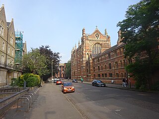
<span class="mw-page-title-main">Linton Road</span> Road in North Oxford, England

Linton Road is a road in North Oxford, England.

<span class="mw-page-title-main">Norham Gardens</span> Road in North Oxford, England

Norham Gardens is a residential road in central North Oxford, England. It adjoins the north end of Parks Road near the junction with Banbury Road, directly opposite St Anne's College. From here it skirts the north side of the Oxford University Parks, ending up at Lady Margaret Hall, a college of Oxford University that was formerly for women only, backing onto the River Cherwell. Public access to the Parks is available from the two ends of the road. To the north of the road are Bradmore Road near the western end and Fyfield Road near the eastern end.

St Margarets Road Road in North Oxford, England

St Margaret's Road is a road in North Oxford, England.

Ralph Henry Carless Davis was a British historian and educator specialising in the European Middle Ages. Davis was born and died in Oxford. He was a leading exponent of strict documentary analysis and interpretation, was keenly interested in architecture and art in history, and was successful at communicating to the public and as a teacher.

Grace Eleanor Hadow

Grace Eleanor Hadow OBE was an author, principal of what would become St Anne's College, Oxford and vice-chairman of the National Federation of Women's Institutes (NFWI).

Walton Manor is a residential suburb in Oxford, England. It is north of Jericho and the Radcliffe Observatory Quarter and forms part of North Oxford. The street layout and many of the area's buildings date from the mid-19th century. It was developed on land belonging to St John's College, Oxford.

Norham Manor Human settlement in England

The Norham Manor estate is a residential suburb in Oxford, England. It is part of central North Oxford. To the north is Park Town with its crescents, to the east is the River Cherwell, to the south are the University Parks and to the west is Walton Manor, on the other side of Banbury Road.

<span class="mw-page-title-main">Fyfield, Oxfordshire</span> Human settlement in England

Fyfield is a village in Fyfield and Tubney civil parish, about 4.5 miles (7 km) west of Abingdon. It was part of Berkshire until the 1974 boundary changes transferred it to Oxfordshire. The village used to be on the main A420 road between Oxford and Faringdon, but a bypass now carries the main road just south of the village.

<span class="mw-page-title-main">Chalfont Road</span> Road in North Oxford, England

Chalfont Road is a road in Walton Manor, North Oxford, England.

<span class="mw-page-title-main">Lathbury Road</span> Road in North Oxford, England

Lathbury Road is a short residential road in north Oxford, England.

<span class="mw-page-title-main">Norham Road</span> Road in North Oxford, England

Norham Road is a road which lies east of the Banbury Road in central North Oxford, a suburb in the city of Oxford, England.

<span class="mw-page-title-main">Blackhall Road, Oxford</span> Road in central Oxford, England

Blackhall Road is a road running between Keble Road to the north and Museum Road to the south in central Oxford, England, dating from the late 19th century. It is named after Black Hall, dating from at least 1519, fronting onto St Giles', and now part of St John's College. Houses in the road were leased by St John's College between 1865–75.

<span class="mw-page-title-main">Bradmore Road</span> Road in North Oxford, England

Bradmore Road is a residential road in North Oxford, England.

<span class="mw-page-title-main">Frederick Codd</span>

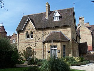
Frederick Codd was a British Gothic Revival architect and speculative builder who designed and built many Victorian houses in North Oxford, England.

<span class="mw-page-title-main">Crick Road</span> Road in North Oxford, England

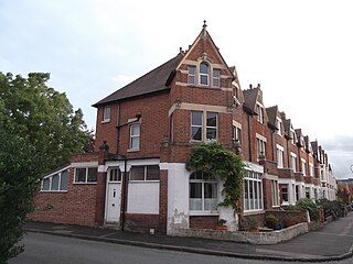
Crick Road is a road in North Oxford, England, an area characterised by large Victorian Gothic villas.

Bertha Johnson

Bertha Jane Johnson, née Todd, was the principal of the Society of Oxford Home-Students, which would become St Anne's College, University of Oxford, and a campaigner for women's education.

References

  1. 1 2 3 Hinchcliffe, Tanis (1992). North Oxford. New Haven & London: Yale University Press. pp. 55, 112, 225. ISBN   0-14-071045-0.
  2. "Fyfield Road houses". Lady Margaret Hall, Oxford . Retrieved 30 August 2012.
  3. "Fyfield Road". Kelly's Directory of Oxford. Kelly's Directories. 1976. p. 338.
  4. Sherwood, Jennifer; Pevsner, Nikolaus (1974). The Buildings of England: Oxfordshire. Penguin Books. p. 318. ISBN   0-14-071045-0.
  5. Inglis, Fred (2009). History Man: The Life of R. G. Collingwood. Princeton University Press. pp. 101–102. ISBN   978-0691150055.
  6. Law, Cheryl (2000). "HADOW, Grace Eleanor". Women, A Modern Political Dictionary . I. B. Tauris. pp.  71–72. ISBN   1 86064 502 X.
  7. Weaver, John Reginald Homer; Poole, Austin Lane, eds. (1933). Henry William Carless Davis, 1874–1928: a memoir. Constable and Company. pp. 34, 43.
  8. Symonds, Ann Spokes (1997). "The Gilis". The Changing Faces of North Oxford. Vol. Book One. Robert Boyd Publications. pp. 98–99. ISBN   1-899536-25-6.

Coordinates: 51°45′54″N1°15′20″W / 51.7651°N 1.2555°W / 51.7651; -1.2555