Gaga'emauga

Last updated
Gaga'emauga
District
Samoan fale, Lelepa village, Savaii, Samoa 2009.JPG
Fale tele, meeting house, Lelepa village in Gaga'emauga district. Architecture of Samoa dictate seating positions in cultural ceremony & ritual.
Samoa-Gaga'emauga.png
Map of Samoa showing Gaga'emauga district
Country Flag of Samoa.svg  Samoa
Population
 (2016)
  Total7,840
Time zone -11

Gaga'emauga is a district on the island of Savai'i in Samoa. The district is situated on the central north side of Savai'i. The name Gaga'emauga literally means "near side of the mountain", meaning the eastern side of the mountain chain running through the centre of Savai'i Island.

Contents

The traditional centre of the district is Saleaula, where the district chiefs (matai) and orators meet at Vaitu’utu’u malae.

Like most villages in Samoa, the villages in Gaga'emauga are situated by the sea although there are some settlements inland, including Patamea and Samalae'ulu.

Reverend George Pratt (1817–1894), a missionary with the London Missionary Society, lived in Matautu (1839–1879) [1] and authored the first grammar and dictionary of the Samoan language, "A Grammar and Dictionary of the Samoan Language, with English and Samoan Vocabulary", which was first printed in 1862 at the Samoa Mission Press. [2]

The village of Saleaula maintains strong traditional connections with Safotulafai to the east, through the paramount chiefly title of Letufuga. Safotulafai is the capital of the political district Fa'asaleleaga.

Exclaves on Upolu

Mt Matavanu eruption, 1905. (photo by Alfred John Tattersall) Matavanu volcanic eruption - Savai'i 1905.jpg
Mt Matavanu eruption, 1905. (photo by Alfred John Tattersall)

Two small exclaves of Gaga'emauga district are situated on the island of Upolu, following the resettlement of villages destroyed during volcanic eruptions of Mt Matavanu in the early 1900s. These exclaves are Le'auva'a and Salamumu villages which remain politically part of Savai'i despite their relocation.

Volcanic eruptions 1900s

Lava fields on Savai'i. Lava Fields - Savai'i island - Samoa.jpg
Lava fields on Savai'i.

The relocated villages of Gaga'emauga district on the main island Upolu was a result of 1905 - 1911 volcanic eruptions of Mt Matavanu, [3] situated about 11 km inland from Matautu on the central north coast. Lava flows from eruptions destroyed villages in its path, including Saleaula and Salago villages, transforming the northern half of this district into lava fields which are still visible today, especially at Saleaula. The people of the affected areas were evacuated to Upolu, where they established the villages of Le'auva'a and Salamumu. Despite the move, they still retain their traditional links and fa'alupega (genealogy) affiliations to Gagaemauga. The names Leava'a and Salamumu denote the events of the 1905 Mt Matavanu eruption. In recent years, a few families have re-built houses on the lava fields where vegetation is still sparse.

Matautu, 1902, Gaga'emauga district Matautu village Savai'i 1902.jpg
Matautu, 1902, Gaga'emauga district

Itu o Tane

Gaga'emauga and the neighbouring political district Gagaifomauga are together referred to as Itu-o-Tane, 'The Side of Men.' [4] The term Itu-o-Tane originates from the bravery of this north coast side in war, and in particular the 1830 war with A'ana. [5] In contrast, part of the island's south coast is known as Itu-o-Fafine, 'The Side of Women.'

Government administration

During World War II, the village of Fagamalo, a sub-village pito nu'u of the larger Matautu village, had a wharf and anchorage and was the main government administrative centre on Savai'i. Fagamalo was also the home of the colonial resident commissioner of Savai'i when Allied forces were defending the South Pacific against Japan. [6] In modern times, the government administration on Savai'i has moved to Tuasivi in the Fa'asaleleaga district, where there is a hospital, a police station, and judicial court offices.

Schools

See also

Related Research Articles

Savaii Island in the Samoan Islands chain

Savaiʻi is the largest and highest island in Samoa and the Samoan Islands chain. The island is the sixth largest in Polynesia, behind the three main islands of New Zealand and the Hawaiian Islands of Hawaii and Maui.

Districts of Samoa

Samoa is made up of eleven itūmālō. These are the traditional eleven districts that were established well before European arrival. Each district has its own constitutional foundation (faavae) based on the traditional order of title precedence found in each district's faalupega.

Tuamasaga District in Samoa

Tuamāsaga is a district of Samoa, with a population of 95,907. The geographic area of Tuamasaga covers the central part of Upolu island.

Faasaleleaga District in Samoa

Fa'asaleleaga is a district of Samoa situated on the eastern side of Savai'i island. It has a population of 13,566.

Salamumu is a village on the south west coast of Upolu island in Samoa. The village has two settlements, Salamumu Uta and Salamumu Tai.

Matautu is the name of different villages in Samoa. Places named Matautu are found on the two largest islands, Upolu and Savai'i.

Saleaula Village in Gagaemauga, Samoa

Sale'aula is a village on the central north coast of Savai'i island in Samoa and is the traditional center of the Gaga'emauga political district. Chief council meetings are held at Vaitu’utu’u malae in the village.

Fagamalo Village in Gagaemauga, Samoa

Not to be confused with Fagamalo, American Samoa

Satoalepai Village in Gagaemauga, Samoa

Sato'alepai is a village situated on the central north coast of the island of Savai'i in Samoa. Sato'alepai is in the political district of Gaga'emauga.

Mount Matavanu mountain in Samoa

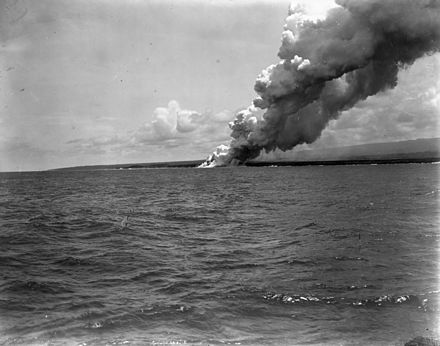
Mt Matavanu is an active volcano on the island of Savai'i in Samoa.

Mauna Afi is a volcanic mountain on the island of Savai'i in Samoa. Its name means Burning Mountain or Mountain of Fire, from the Samoan language mauga (mountain) and afi (fire).

Mauga Village in Gagaemauga, Samoa

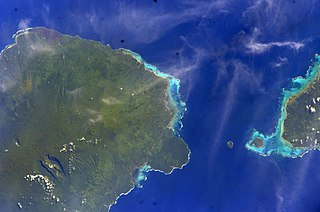
Mauga is a village in Savai'i island in Samoa. The word mauga means mountain in the Samoan language. The settlement is built around the crater of a small volcano. Mauga is in the Gaga'emauga political district near the central north coast of the island. The large meeting houses of the village are situated in a circle facing each other around the rim of the crater which can be seen in high altitude photography.

Samalaeulu

Samalae'ulu is a village on the northeast side of Savai'i island in Samoa. The village is part of the electoral constituency Gaga'emauga I which includes the neighbouring villages of Patamea and the smaller settlement of Mauga which is built around a volcanic crater.

Avao

Avao is a village on the north central coast of Savai'i island in Samoa. The village is part of the electoral constituency Gaga'emauga III, which is included in the larger political district of Gaga'emauga.

Lelepa, Samoa Samaoan island

Lelepa is a village on the north central coast of Savai'i island in Samoa. The village is part of the electoral constituency Gaga'emauga III which forms part of the larger political district of Gaga'emauga.

Saleia is a village on the north central coast of Savai'i island in Samoa. The village is part of the electoral constituency Gaga'emauga III which forms part of the larger political district of Gaga'emauga.

Safa'i is a village on the north central coast of Savai'i island in Samoa. The village is part of the electoral constituency Gaga'emauga III which forms part of the larger political district Gaga'emauga.

Leauvaa Village in Gagaemauga, Samoa

Le'auva'a is a village on the island of Upolu in Samoa. The population is 3,041.

Vaipouli College

Vaipouli College is a secondary school on Savai'i island in Samoa. The college is co-educational, open to male and female students from Year 9 - 13. The college is also known as Salafai College, in reference to Salafai, another name for the island of Savai'i.

References

  1. Ron Crocombe, Majorie Crocombe. Works of ta'unga: records of a polynesian traveller in the south seas, 1833-1896. University of the South Pacific. p. 19. ISBN   982-02-0232-9.
  2. "New Zealand Electronic Text Centre" . Retrieved 2009-04-16.
  3. "Samoa - Treasured islands of the South Pacific - Samoa.travel". Archived from the original on 2009-08-30. Retrieved 2009-10-04.
  4. Malama Meleisea (1987). Lagaga: A Short History of Western Samoa. editorips@usp.ac.fj. pp. 121–. ISBN   978-982-02-0029-6.
  5. O Samoa Anamua by Siaosi Tana, p.197, 1884. Retrieved 27 October 2009
  6. Gordon L. Rottman (2002). World War II Pacific Island Guide: A Geo-military Study. Greenwood Publishing Group. pp. 87–. ISBN   978-0-313-31395-0.

Coordinates: 13°30′S172°15′W / 13.500°S 172.250°W / -13.500; -172.250