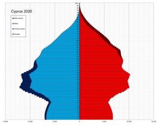
The people of Cyprus are broadly divided into two main ethnic communities, Greek Cypriots and Turkish Cypriots, who share many cultural traits but maintain distinct identities based on ethnicity, religion, language, and close ties with Greece and Turkey respectively. Before the dispute started in 1964 the peoples of Cyprus were dispersed over the entire island.
Turkish Cypriots or Cypriot Turks are ethnic Turks originating from Cyprus. Turkish Cypriots are mainly Sunni Muslims. Following the Ottoman conquest of the island in 1571, about 30,000 Turkish settlers were given land once they arrived in Cyprus. Additionally, many of the island's local Christians converted to Islam during the early years of Ottoman rule. Nonetheless, the influx of mainly Muslim settlers to Cyprus continued intermittently until the end of the Ottoman period. Today, while Northern Cyprus is home to a significant part of the Turkish Cypriot population, the majority of Turkish Cypriots live abroad, forming the Turkish Cypriot diaspora. This diaspora came into existence after the Ottoman Empire transferred the control of the island to the British Empire, as many Turkish Cypriots emigrated primarily to Turkey and the United Kingdom for political and economic reasons.
Enkomi is a village near Famagusta in Cyprus. It is a short distance from a prominent 2nd millenium BC archaeological site also named Enkomi. Enkomi is under the de facto control of Northern Cyprus.

Yialousa, or Gialousa,is a town under the de facto control of Northern Cyprus, claimed by Cyprus. Yialousa is located on the Karpas Peninsula, and one of the sub-districts of the İskele District. In 2011, Yialousa had a population of 1,774.
Agios Efstathios is a village in Cyprus, located on the Karpas Peninsula. It is under the de facto control of Northern Cyprus. As of 2011, Agios Efstathios had a population of 36. It has always been a Turkish Cypriot village.
Larnakas tis Lapithou is a village in Cyprus, near the town of Lapithos. It is under the de facto control of Northern Cyprus. The Anat Athena bilingual Greek-Phoenician inscription was found near the village in the 19th century.
Kyra is a village located in the Nicosia District of Cyprus, 6 km east of Morphou. De facto, it is under the control of Northern Cyprus.
Katokopia is a village located in the Nicosia District of Cyprus, 7 km east of Morphou. De facto, it is under the control of Northern Cyprus.
Nikitas is a village in Cyprus, 4 km southwest of Morphou. De facto, it is under the control of the Turkish Republic of Northern Cyprus.
Kampyli is a small Turkish Cypriot village in Cyprus, located approximately 3 km (1.9 mi) east of Myrtou. It is under the de facto control of Northern Cyprus. In 1831, 30% of the village's inhabitants were Maronites. They all left by 1940, and, around that time, Muslim families from Larnakas tis Lapithou moved into Kampyli. As of 2011, Kampyli had population of 194.
Elia is a village in Cyprus, located east of Lefka. De facto, it is under the control of Northern Cyprus.

Karavostasi is a town in Cyprus, 6 kilometres (3.7 mi) north of Lefka. It is under the de facto control of Northern Cyprus.
Ambelikou is a village in Cyprus, west of Lefka. De facto, it is under the control of Northern Cyprus.
Loutros is a small village located in the Nicosia District of Cyprus, west of the town of Karavostasi. De facto, it is under the control of Northern Cyprus.
Neo Chorio is a village in the Nicosia District of Cyprus, 2 km south of Kythrea. De facto, it is under the control of Northern Cyprus.
Kalopsida is a village in the Famagusta District of Cyprus, 8 kilometres (5.0 mi) east of Lysi. It is under the de facto control of Northern Cyprus.
Agios Iakovos is a village in Cyprus, located 9 kilometres (5.6 mi) northwest of Trikomo. It is under the de facto control of Northern Cyprus. As of 2011, Agios Iakovos had a population of 229 inhabitants. It has historically been inhabited by Turkish Cypriots.
Agios Ilias is a village in the Famagusta District of Cyprus, located 6 kilometres (3.7 mi) north-east of Trikomo. It is under the de facto control of Northern Cyprus.

Davlos is a village in the Famagusta District of Cyprus, located on the northern coast, east of Kyrenia, near Kantara Castle. It is under de facto control of Northern Cyprus, forming part of its İskele District.
Agios Symeon is a village in Cyprus, located on the Karpas Peninsula. It is under the de facto control of Northern Cyprus. As of 2011, Avtepe had a population of 119. It has always been inhabited by Turkish Cypriots.