
Madison County is a county in the U.S. state of Montana. As of the 2020 census, the population was 8,623. Its county seat is Virginia City. The county was founded in 1865; at the time it was part of the Montana Territory.

The Absaroka Range is a sub-range of the Rocky Mountains in the United States. The range stretches about 150 mi (240 km) across the Montana–Wyoming border, and 75 mi (120 km) at its widest, forming the eastern boundary of Yellowstone National Park along Paradise Valley, and the western side of the Bighorn Basin. The range borders the Beartooth Mountains to the north and the Wind River Range to the south. The northern edge of the range rests along I-90 and Livingston, Montana. The highest peak in the range is Francs Peak, located in Wyoming at 13,153 ft (4,009 m). There are 46 other peaks over 12,000 ft (3,700 m).

Quake Lake is a lake in the western United States, on the Madison River in southwestern Montana. It was created after an earthquake struck on August 17, 1959, with 28 fatalities. Northwest of West Yellowstone, Quake Lake is six miles (10 km) in length with a maximum depth of 125 feet (38 m).
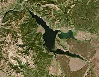
Hebgen Lake is a reservoir created by the Hebgen Dam, located in Gallatin County in southwest Montana. It is well known for the 1959 Hebgen Lake earthquake which occurred nearby on August 17, 1959, forming Quake Lake, which is located immediately downstream.
Crazy Peak, elevation 11,214 ft (3,418 m), is the highest peak in the Crazy Mountains, an isolated range of the Montana Rockies, in the United States. Crazy Peak dominates the surroundings, rising over 7,000 feet (2,100 m) above the Yellowstone River Valley, and is the highest peak in Montana north of the Beartooth Mountains, which are 50 miles (80 km) to the south. Crazy Peak is also the most topographically prominent peak in Montana. A small glacier exists on the northeast slope of the mountain. The mountain is located on private land within the Gallatin National Forest.

Electric Peak is the tallest mountain in the Gallatin Range of southern Montana, close to the Wyoming border and rises to an altitude of 10,969 feet (3,343 m). The peak has some of the greatest physical relief in Yellowstone National Park, rising 3,389 ft (1,033 m) above its base.

Missouri Headwaters State Park is a public recreation area occupying 535 acres (217 ha) at the site of the official start of the Missouri River. The park offers camping, hiking trails, hunting, and water-related activities. It is located on Trident Road northeast of Three Forks, Montana at an elevation of 4,045 feet (1,233 m). The park includes the Three Forks of the Missouri National Historic Landmark, designated in 1960 because the site is one where the Lewis and Clark Expedition camped in 1805.

Mount Holmes is a prominent mountain peak in Yellowstone National Park. It is the tallest mountain in the Wyoming portion of the Gallatin Range. Mount Holmes is located in the northwestern part of the park and marks the southern terminus of the Gallatin Range. It is the source of Indian Creek, a tributary of the Gardner River.

The Madison Range is a mountain range located in the Rocky Mountains of Montana and Idaho in the United States. The range was named in honor of future President of the United States, then U.S. Secretary of State James Madison by Meriwether Lewis as the Lewis and Clark Expedition travelled through Montana in 1805. The range extends 80 miles (130 km) from West Yellowstone, Montana to Bozeman, Montana and is flanked by the Madison River on the west and the Gallatin River to the east. The highest point in the range is Hilgard Peak at 11,316 ft (3,449 m), a remote peak that wasn't climbed until 1948.

Hilgard Peak is the tallest mountain in the Madison Range in the U.S. state of Montana. The summit is located in a remote section of the Lee Metcalf Wilderness within the Beaverhead-Deerlodge National Forest. The peak was first climbed in 1948. The peak was named for E. W. Hilgard, a geology professor who served on the Hayden Expedition during its exploration of the Yellowstone area.

The Spanish Peaks, avg el. 8,441 feet (2,573 m), is a mountain range between Bozeman, Montana and Ennis, Montana in Gallatin and Madison County, Montana. It is a sub-range of the much larger Madison Range, itself a sub-range of the Rocky Mountains. The hydrological divide of the range serves as the border between Gallatin and Madison County, Montana. The Spanish Peaks are made up of 1.6 billion year-old gneiss, making them the oldest peaks in the Madison Range, predating the rest of the range by 50-60 million years. Gallatin Peak, el. 11,015 ft., is the highest peak in the group.

Purple Mountain, elevation 8,392 feet (2,558 m), is a mountain peak in the southern section of the Gallatin Range in Yellowstone National Park, in the U.S. state of Montana. The Purple Mountain Trail ascends to the summit from Madison Junction. It is located near the Lava Creek Tuff.

McDonald Peak, elevation 9,820 feet (2,993 m), is located in the U.S. state of Montana and is the highest peak in the Mission Mountains. McDonald Peak is situated within the Flathead Indian Reservation. The peak has the second greatest topographic prominence of all summits within Montana and is almost 80 miles (130 km) away from the next highest mountain in the state. McDonald Glacier is on the north slope of the peak.
Koch Peak is the one of the taller mountains in the Madison Range in the U.S. state of Montana. The summit is located in Lee Metcalf Wilderness within Gallatin and Beaverhead-Deerlodge National Forests. Koch Peak is tallest in a group of summits collectively called the Taylor Peaks.
Echo Peak is the one of the taller mountains in the Madison Range in the U.S. state of Montana. The summit is located in Lee Metcalf Wilderness within Gallatin and Beaverhead-Deerlodge National Forests. Echo Peak is less than 2 mi (3.2 km) north of Hilgard Peak.
Imp Peak is in the Madison Range in the U.S. state of Montana. The summit is located in Lee Metcalf Wilderness within Gallatin and Beaverhead-Deerlodge National Forests. Echo Peak is 3.1 mi (5.0 km) south of Koch Peak.

Lone Mountain is in the Madison Range in the U.S. state of Montana. The summit is located in Lee Metcalf Wilderness within Gallatin and Beaverhead-Deerlodge National Forests. Lone Mountain is 16.63 mi (26.76 km) north of Koch Peak.
Mount Cowen is in the Absaroka Range in the U.S. state of Montana. The peak is located in Gallatin National Forest. Several small glacierets exist on the flanks of the peak, especially on the northern slopes.

Lonesome Mountain is an 11,399-foot (3,474-metre) mountain summit located in Carbon County, Montana.

