Ganghwa County

Last updated
Ganghwa
강화군
Korean transcription(s)
  Hanja
  Revised RomanizationGanghwa-gun
  McCune-ReischauerKanghwa-kun
Dolmen Ganghwa Island.JPG
Flag of Ganghwa, Incheon.svg
Ganghwagun location.svg
Country South Korea
Region Sudogwon
Provincial level Incheon
Administrative divisions 1 eup, 13 myeon, 96 ri
Area
  Total411.4 km2 (158.8 sq mi)
Population
 (2020)
  Total69,154
  Density170/km2 (440/sq mi)
  Dialect
Seoul
Website Ganghwa County Office

Ganghwa County is a county in the city of Incheon, South Korea. The county is composed of Ganghwa Island, and the minor islands around it.

Contents

History

Ganghwa County contains some of the most important historical sites in Korea. These sites cover the prehistoric old and new stone ages, as well as the bronze and iron ages. Additionally there are numerous historic sites.

An example of a dolmen on Ganghwa GMJ 0153.jpg
An example of a dolmen on Ganghwa

Ganghwa Island is rich in dolmen, and they have been designated a World Heritage Site. [1] There are about 150 dolmen on the island. Their distribution shows that these dolmen were closely related to fishing in the Bronze Age, although they are now separated from the sea. [2] They are located on the slopes of mountains and are thus higher in elevation than their counterparts. It is believed, but not proved, that the Ganghwa dolmen are the earliest Korean ones made, because the designs of the dolmen in Bugeun-ri and Gocheon-ri are resemble those in Ganghwa. [3]

Dangun, the founder of Gojoseon, is said to have made an altar on top of Mani-san and offered sacrifices to his ancestors. [4]

In the 9th century, the Unified Silla established a garrison on the island to combat piracy. Their commander, Wang Geon, established his military reputation at the garrison, and later went on to found the Kingdom of Goryeo. In the 13th century, the court of Goryeo took refuge on the island as Mongol forces invaded in 1232. After Goryeo capitulated to the Mongols, the elite forces on the island rose up, beginning the Sambyeolcho Rebellion.

In the early 19th century, Catholicism was introduced into Korea despite its official proscription by the Korean court. The Korean court clamped down on the illicit French missionaries, massacring French Catholic missionaries and Korean converts alike leading to a punitive French expedition to Korea in 1866. The encounter lasted nearly six weeks. In the first battle, a Korean infantry division lost heavily, and Korean General Yang Heon-su concluded that only a large cavalry division could stand up to French firepower. On 9 November, the French were checked when they attempted to occupy the strategically important Cheondeung (Jeongdeung–sa) Temple, on the island's south coast. Stiff Korean resistance, coupled by the overwhelming numerical superiority of the Korean defenders, now numbering 10,000 men, [5] forced a French retreat with dozens of casualties but no deaths, finally resulting in the French retreating, and abandoning the island.

In 1871, following the General Sherman Incident, the United States Navy launched an expedition against the soldiers at Ganghwa Island, resulting in the Battle of Ganghwa.

In 1875, the Japanese ship, Unyo, made and incursion into the restricted coastal zone, under the guise of measuring the coastline. It fired a few shots at the fortress on the island. When the Unyo sent a boat to the island, the Korean garrison fired a few shots back. The Japanese argued that this was an aggressive act, and demanded concessions. Early in the following year, Japan sent a large Imperial Japanese Navy fleet to Korea, which forced the government to sign the unequal Treaty of Ganghwa. That agreement, concluded on Ganghwa Island, officially opened Korea to Japanese external trade for the first time during the 19th century.

Ganghwa was raised to the status of a county in 1906, and incorporated into the Incheon Metropolitan City in 1995.

Climate

Climate data for Ganghwa (1991–2020 normals, extremes 1972–present)
MonthJanFebMarAprMayJunJulAugSepOctNovDecYear
Record high °C (°F)12.6
(54.7)
17.4
(63.3)
22.3
(72.1)
29.2
(84.6)
31.0
(87.8)
33.2
(91.8)
35.5
(95.9)
35.8
(96.4)
31.7
(89.1)
28.3
(82.9)
23.8
(74.8)
16.0
(60.8)
35.8
(96.4)
Average high °C (°F)1.7
(35.1)
4.5
(40.1)
9.8
(49.6)
16.2
(61.2)
21.4
(70.5)
25.4
(77.7)
27.6
(81.7)
29.0
(84.2)
25.5
(77.9)
19.5
(67.1)
11.5
(52.7)
3.9
(39.0)
16.3
(61.3)
Daily mean °C (°F)−3.2
(26.2)
−0.7
(30.7)
4.6
(40.3)
10.7
(51.3)
16.0
(60.8)
20.5
(68.9)
23.7
(74.7)
24.7
(76.5)
20.2
(68.4)
13.7
(56.7)
6.3
(43.3)
−0.9
(30.4)
11.3
(52.3)
Average low °C (°F)−8.1
(17.4)
−5.8
(21.6)
−0.6
(30.9)
5.3
(41.5)
11.0
(51.8)
16.3
(61.3)
20.6
(69.1)
21.2
(70.2)
15.6
(60.1)
8.1
(46.6)
1.2
(34.2)
−5.7
(21.7)
6.6
(43.9)
Record low °C (°F)−22.5
(−8.5)
−19.4
(−2.9)
−11.3
(11.7)
−4.4
(24.1)
1.6
(34.9)
6.9
(44.4)
12.7
(54.9)
12.5
(54.5)
3.0
(37.4)
−4.2
(24.4)
−12.0
(10.4)
−19.8
(−3.6)
−22.5
(−8.5)
Average precipitation mm (inches)15.6
(0.61)
22.5
(0.89)
31.4
(1.24)
64.9
(2.56)
110.9
(4.37)
110.0
(4.33)
355.6
(14.00)
300.4
(11.83)
131.5
(5.18)
55.8
(2.20)
46.3
(1.82)
21.3
(0.84)
1,266.2
(49.85)
Average precipitation days (≥ 0.1 mm)5.04.86.07.58.28.614.111.97.45.67.56.693.2
Average snowy days7.34.32.40.20.00.00.00.00.00.11.55.120.6
Average relative humidity (%)63.661.061.462.468.675.182.879.973.868.967.865.469.2
Mean monthly sunshine hours 186.2186.5217.0221.7235.3208.5153.0184.9203.8214.3166.0171.82,349
Percent possible sunshine 58.761.858.959.054.850.038.647.757.463.355.755.654.6
Source: Korea Meteorological Administration (snow and percent sunshine 1981–2010) [6] [7] [8]

Speciality

About 70% of Ganghwa's citizens are engaged in farming, mainly rice. Fishery and forestry are other occupations practiced.

Hwamunseok is a well-known traditional fancy matting. Since the Goryeo dynasty (10th-14th centuries), hwamunseok has been produced and exported to China and Japan. The mats are produced in the home handicraft industry. Under an order given by the royal court of the Joseon dynasty over 100 years ago, craftsman Han Chunggyo from the white-mat producing village, Yango-ri, Haesongmyeon, Ganghwa-gun, achieved a successful product by the design of his own idea. Thereafter, various designs have been developed and manufacturing techniques have been improved. [9]

The Ganghwa turnip is a specialty of the area. It has been cultivated since the 5th century. This is recorded in the 17th-century Dongui Bogam book of oriental medicine." [10]

World Heritages

In Ganghwa county, dolmens are registered by UNESCO as a World Heritage Site. In three regions of South Korea including Hwasun and Gochang, Ganghwa's dolmens are famous sites to study ancient culture.

Administrative Divisions of Ganghwa-gun

Administrative divisions 04-09-ganghwa-en.svg
Administrative divisions

Sister cities

Related Research Articles

<span class="mw-page-title-main">Dolmen</span> Type of single-chamber megalithic tomb

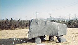
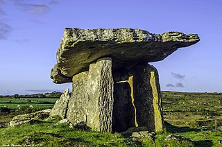
A dolmen or portal tomb is a type of single-chamber megalithic tomb, usually consisting of two or more upright megaliths supporting a large flat horizontal capstone or "table". Most date from the Late Neolithic period and were sometimes covered with earth or smaller stones to form a tumulus. Small pad-stones may be wedged between the cap and supporting stones to achieve a level appearance. In many instances, the covering has eroded away, leaving only the stone "skeleton".

<span class="mw-page-title-main">Samcheok</span> Municipal City in Gangwon, South Korea

Samcheok is a city in Gangwon-do, South Korea.

<span class="mw-page-title-main">Suncheon</span> Municipal City in Honam, South Korea

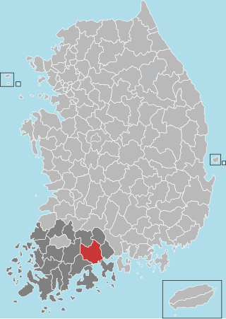
Suncheon (Suncheon-si) is the largest city in Jeollanam-do, South Korea, with a population of 280,719 as of 2022. It is located in the southeast of the province and is a scenic agricultural and industrial city, known for tourist attractions, such as Suncheon Bay. The port city of Yeosu is around forty minutes south of Suncheon and Gwangyang twenty minutes to the east of the city.

<span class="mw-page-title-main">Gangjin County</span> County in Honam, South Korea

Gangjin County (Gangjin-gun) is a county in South Jeolla Province, South Korea. Gangjin county proper was established in 1895. The county office is located in Gangjin-eup.

<span class="mw-page-title-main">Hampyeong County</span> County in Honam, South Korea

Hampyeong County (Hampyeong-gun) is a county in South Jeolla Province, South Korea.

<span class="mw-page-title-main">Hwasun County</span> County in Honam, South Korea

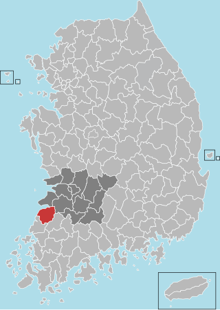
Hwasun County is a county in South Jeolla Province, South Korea.

<span class="mw-page-title-main">Buan County</span> County in Honam, South Korea

Buan County (Buan-gun) is a county in North Jeolla Province, South Korea. It is bounded by the city of Jeongeup on the east, the county of Gochang on the south, the city of Gimje on the north, and Yellow Sea on the west. Buan is divided into 1 eup, 12 myeon, and 510 ri. Buan had a 2001 estimated population of 74,716 people and a 2018 population of 54,441 people with an area of 493.35 km2. Famous people from Buan include Joseon Dynasty kisaeng and poet, Yi Mae-chang. Like many rural areas in southern Korea, it has seen shrinking population with many younger people moving north to larger cities such as Seoul. This county should not be confused with Muan, the new capital of South Jeolla Province.

<span class="mw-page-title-main">Gochang County</span> County in Honam, South Korea

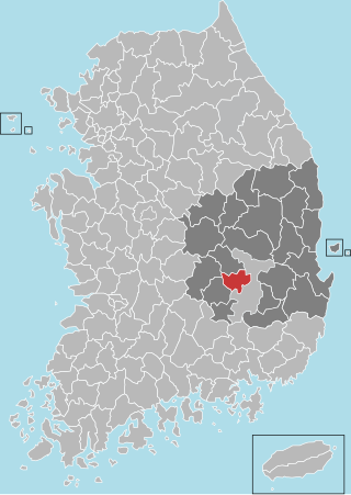
Gochang County (Gochang-gun) is a county in North Jeolla Province, South Korea. It is a rural area, and is home to only one institution of higher education: Gochang Polytechnic College.

Ganghwa may refer to:

<span class="mw-page-title-main">Icheon</span> Municipal City in Sudogwon, South Korea

Icheon is a city in Gyeonggi Province, South Korea.

<span class="mw-page-title-main">Dangjin</span> Municipal City in Hoseo, South Korea

Dangjin is a city in South Chungcheong Province, South Korea. It stands on the south shore of the Bay of Asan. Dangjin borders Incheon, Pyeongtaek, and Hwaseong by sea, and Seosan, Yesan, and Asan by land. Its name means "Tang ferry," and refers to the historic role of Dangjin's harbor in connecting Korea to the other side of the Yellow Sea. This role continues to be important in the city's economy, which relies on a mixture of agriculture and heavy industry. The city has the same Hanja name (唐津市) as Karatsu in Saga Prefecture, Japan.

<span class="mw-page-title-main">Seogwipo</span> Administrative city in Jeju, South Korea

Seogwipo is the second-largest city on Jeju Island, settled on a rocky volcanic coastline in the southern part of Jeju Province, South Korea. In July 2006, Seogwipo's boundaries were expanded to include the entire southern half of Jeju island. A UNESCO World Heritage Site and 2002 FIFA World Cup host, it had a population of 155,691 as of December 31, 2011.

<span class="mw-page-title-main">Chilgok County</span> County in Yeongnam, South Korea

Chilgok County (Chilgok-gun) is located at south-west part of North Gyeongsang Province. It is close by Gunwi County on the east while adjoins with Gimchon-si, Seongju County on the west. It is also a transportation hub where the Nakdong river flows through and an Urban-Farming complex that adjoins with Gumi City and Daegu Metropolitan city.

<span class="mw-page-title-main">Ulleung County</span> County in North Gyeongsang, South Korea

Ulleung County is a county in North Gyeongsang Province, South Korea.

<span class="mw-page-title-main">Namhae County</span> County in Yeongnam, South Korea

Namhae County (Namhae-gun) is a county in South Gyeongsang Province, South Korea.

<span class="mw-page-title-main">Ganghwa Island</span> Island in the Yellow Sea, South Korea

Ganghwa Island, also known by its native name Ganghwado, is a South Korean island in the estuary of the Han River. It is in the Yellow Sea, off Korea's west coast. The island is separated from Gimpo by a narrow channel spanned by two bridges, and from Kaesong (Gaeseong) in North Korea by the main channel of the Han River. North Korea can be seen on clear days from less than two kilometers away on South Korea's Ganghwa Island allowing better views of North Korean villages than from elsewhere in South Korea.

<span class="mw-page-title-main">Mongol invasions of Korea</span> Mongol Yuán Conquests of the Korean peninsula

A series of campaigns were conducted between 1231 and 1270 by the Mongol Empire against the Goryeo dynasty of Korea. There were seven major campaigns at tremendous cost to civilian lives, the last campaign made most of Goryeo a vassal state of the Yuan dynasty for approximately 80 years. However, rebellion movements existed throughout this time and in 1274, some Goryeo territory existed outside of Mongol control.

<span class="mw-page-title-main">Gochang, Hwasun and Ganghwa Dolmen Sites</span> UNESCO World Heritage Site

The Gochang, Hwasun and Ganghwa Dolmen Sites are the location of hundreds of stone dolmens which were used as grave markers, and for ritual purposes during the first millennium BCE when the Megalithic Culture was prominent on the Korean Peninsula. The sites were designated as a World Heritage Site by UNESCO in 2000. The Korean Peninsula is home to over 35,000 dolmens, accounting for approximately 40% of the world's total; the Gochang, Hwasun, and Ganghwa sites are themselves home to over 1,000 dolmens.

<span class="mw-page-title-main">Ongjin County, Incheon</span> County in Sudogwon, South Korea

Ongjin County is a county in Incheon Metropolitan City, South Korea. It consists of a group of islands in the Yellow Sea.

References

  1. "Gochang, Hwasun and Ganghwa Dolmen Sites".
  2. younghwan. "강화역사박물관, 강화도의 고인돌". Culture & History Traveling. Retrieved 2018-12-19.
  3. "Ganghwa Bugeun-ri Jisokmyo". Encyclopedia of Korean Culture.
  4. "Korean Foundation Myth". www.imjinscout.com.
  5. Jean-Marie Thiébaud, La présence française en Corée de la fin du XVIIIème siècle à nos jours, p. 23
  6. "Climatological Normals of Korea (1991 ~ 2020)" (PDF) (in Korean). Korea Meteorological Administration. Archived from the original (PDF) on 29 January 2022. Retrieved 4 April 2022.
  7. 순위값 - 구역별조회 (in Korean). Korea Meteorological Administration. Retrieved 4 April 2022.
  8. "Climatological Normals of Korea" (PDF). Korea Meteorological Administration. 2011. Archived from the original (PDF) on 7 December 2016. Retrieved 8 December 2016.
  9. Official page of Ganghwa Archived August 17, 2009, at the Wayback Machine
  10. Ganghwa County [ permanent dead link ]

37°44′20″N126°29′22″E / 37.73889°N 126.48944°E / 37.73889; 126.48944