Strasburg is an unincorporated town located just 30 minutes east of downtown Denver along the I-70 corridor. It is home to Strasburg School District 31-J, and there are several small businesses, medical clinics, and a post office. Strasburg is a census-designated place (CDP) located in and governed by Adams and Arapahoe counties, Colorado, United States. The CDP is a part of the Denver–Aurora–Lakewood, CO Metropolitan Statistical Area. The Strasburg post office has the ZIP Code 80136. At the United States Census 2020, the population of the Strasburg CDP was 3,307.
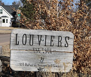
Louviers is an unincorporated town, a post office, and a census-designated place (CDP) located in and governed by Douglas County, Colorado, United States. The CDP is a part of the Denver–Aurora–Lakewood, CO Metropolitan Statistical Area. The Louviers post office has the ZIP Code 80131. At the United States Census 2020, the population of the Louviers CDP was 293.

Kittredge is an unincorporated town, a post office, and a census-designated place (CDP) located in and governed by Jefferson County, Colorado, United States. The CDP is a part of the Denver–Aurora–Lakewood, CO Metropolitan Statistical Area. The Kittredge post office has the ZIP code 80457. At the United States Census 2020, the population of the Kittredge CDP was 1,308.

Avondale is a census-designated place (CDP) and post office in and governed by Pueblo County, Colorado, United States. The CDP is a part of the Pueblo, CO Metropolitan Statistical Area. The Avondale post office has the ZIP Code 81022. At the United States Census 2020, the population of the Avondale CDP was 594, while the population of the 81022 ZIP Code Tabulation Area was 1,624 including adjacent areas.

Conejos is an unincorporated town, a post office, a census-designated place (CDP), and the county seat of Conejos County, Colorado, United States. The Conejos post office has the ZIP Code 81129. At the United States Census 2020, the population of the Conejos CDP was 46. Conejos is the only unincorporated county seat in the State of Colorado.

Amherst is a census-designated place (CDP) and a post office in and governed by Phillips County, Colorado, United States. The Amherst post office has the ZIP Code 80721. At the United States Census 2020, the population of the Amherst CDP was 47.

Cope is an unincorporated town, a post office, and a census-designated place (CDP) located in and governed by Washington County, Colorado, United States. The population was 53 at the 2020 census. The Cope post office has the ZIP Code 80812.

Howard is a census-designated place (CDP) and post office in and governed by Fremont County, Colorado, United States. The CDP is a part of the Cañon City, CO Micropolitan Statistical Area. The Howard post office has the ZIP Code 81233. At the United States Census 2020, the population of the Howard CDP was 852.

Joes is a census-designated place (CDP) and post office in and governed by Yuma County, Colorado, United States. The Joes post office has the ZIP Code 80822. At the United States Census 2020, the population of the Joes CDP was 82.

Kirk is an unincorporated town, a post office, and a census-designated place (CDP) located in and governed by Yuma County, Colorado, United States. The Kirk post office has the ZIP Code 80824. At the United States Census 2020, the population of the Kirk CDP was 61.
Lazear is an unincorporated town, a census-designated place (CDP), and a post office located in and governed by Delta County, Colorado, United States. The Lazear post office has the ZIP Code 81420. The population was 168 at the 2020 census.

Matheson is a census-designated place (CDP) and post office in and governed by Elbert County, Colorado, United States. The CDP is a part of the Denver–Aurora–Lakewood, CO Metropolitan Statistical Area. The Matheson post office has the ZIP Code 80830. At the United States Census 2020, the population of the Matheson CDP was 79.

McCoy is an unincorporated town, a census-designated place (CDP), and a post office located in and governed by Eagle County, Colorado, United States. The CDP is a part of the Edwards, CO Micropolitan Statistical Area. The McCoy post office has the ZIP Code 80463. At the United States Census 2020, the population of the McCoy CDP was 30.

Phippsburg is a census-designated place (CDP) and a post office in and governed by Routt County, Colorado, United States. The population was 234 at the 2020 census. The CDP is a part of the Steamboat Springs, CO Micropolitan Statistical Area. The Phippsburg post office has the ZIP Code 80469.

Vernon is an unincorporated town, a post office, and the center of a census-designated place (CDP) located in and governed by Yuma County, Colorado, United States. The Vernon post office has the ZIP Code 80755. At the United States Census 2020, the population of the total Vernon CDP was 38; the town's specific population was not recorded.

Weldona is an unincorporated town, a post office, and a census-designated place (CDP) located in and governed by Morgan County, Colorado, United States. The CDP is a part of the Fort Morgan, CO Micropolitan Statistical Area. The Weldona post office has the ZIP Code 80653. At the United States Census 2020, the population of the Weldona CDP was 113.

Weston is an unincorporated town, a post office, and a census-designated place (CDP) located in and governed by Las Animas County, Colorado, United States. The Weston post office has the ZIP Code 81091. At the United States Census 2020, the population of the Weston CDP was 53.

Wolcott is an unincorporated town, a post office, and a census-designated place (CDP) located in and governed by Eagle County, Colorado, United States. The CDP is a part of the Edwards, CO Micropolitan Statistical Area. The Wolcott post office has the ZIP Code 81655. At the United States Census 2020, the population of the Wolcott CDP was 20.

Laird is an unincorporated community and a census-designated place (CDP) located in and governed by Yuma County, Colorado, United States. The population of the Laird CDP was 46 at the United States Census 2020. The Wray post office (Zip Code 80758) serves Laird postal addresses. Laird has the lowest elevation of any community in Colorado at 3,402 feet (1,037 m).

Colona is a census-designated place (CDP) located in and governed by Ouray County, Colorado, United States. The CDP is a part of the Montrose, CO Micropolitan Statistical Area. The population of the Colona CDP was 36 at the United States Census 2020. The Montrose post office (Zip Code 81401) serves the area.