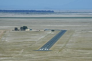
Garissa Airport | |||||||||||
|---|---|---|---|---|---|---|---|---|---|---|---|
| Summary | |||||||||||
| Airport type | Public, Civilian | ||||||||||
| Owner | Kenya Airports Authority | ||||||||||
| Serves | Garissa, Kenya | ||||||||||
| Location | Garissa, | ||||||||||
| Elevation AMSL | 476 ft / 145 m | ||||||||||
| Coordinates | 00°28′07″S39°38′58″E / 0.46861°S 39.64944°E | ||||||||||
| Map | |||||||||||
| Runways | |||||||||||
| |||||||||||
Garissa Airport ( IATA : GAS, ICAO : HKGA) is located in the town of Garissa, Garissa County, near the International border with Somalia.
Its location is approximately 315 kilometres (196 mi), by air, north of Nairobi International Airport, the country's largest civilian airport. [1] The geographic coordinates of this airport are:0° 28' 7.00"N, 39° 38' 58.00"E (Latitude:-0.468610; Longitude:39.649445).
Garissa Airport is a small civilian airport, serving Garissa and surrounding communities. Situated at 145 metres (476 ft) above sea level, the airport has a single asphalt runway 17-35 that measures 3,937 feet (1,200 m) long. [2]
| Airlines | Destinations |
|---|---|
| Freedom Airline [3] | Nairobi–Wilson |
| Mrash Tours & Travel | Nairobi–Wilson |
Liboi is a town in Garissa County, Kenya, at the border with Somalia.

Amboseli Airport is an airport in Kenya.

Lewa Airport is an airport in Kenya.
Bamburi Airport is an airport in Kenya.
Bungoma Airport is an airport in Kenya.
Bura East Airport is an airport in Kenya.
Voi Airport is an airport in Voi, Kenya.
Naivasha Airport is an airport in Naivasha, Kenya.
Mtito Andei Airport is an airport in Kenya.
Moyale Airport, also referred to as Moyale Lower Airport, is an airport located in the town of Moyale, Marsabit County, in the northern part of the Republic of Kenya, at the international border with Ethiopia. Its location is approximately 590 kilometres (370 mi), by air, northeast of Nairobi International Airport, the country's largest civilian airport. The geographic coordinates of this airport are:3° 27' 54.00"N, 39° 6' 18.00"E.
Garba Tula Airport is an airport in Kenya.
Hola Airport is an airport in Kenya.
Marsabit Airport is an airport in Marsabit, Kenya.
Kakamega Airport is a small airport in Kenya. It serves the town of Kakamega. At 1,530 metres (5,020 ft) above sea level, the airport has a single asphalt runway which measures 4,200 feet (1,300 m) in length and 49 feet (15 m) in width.
Kericho Airport is an airport in Kenya.
Kilaguni Airport is an airport in Kenya.
Kimwarer Airport is an airport in Kenya.
Kisii Airport is an airport in Kisii County, Kenya.
Kitale Airport is an airport in Kitale, Kenya.
Mackinnon Road Airport is an airport in Mackinnon Road, Kenya.