Busia Airport

Last updated

Busia Airport
Summary
Airport type Public, Civilian
Owner Kenya Airports Authority
Serves Busia, Kenya
Location Busia, Flag of Kenya.svg Kenya
Elevation  AMSL 3,990 ft / 1,216 m
Coordinates 00°27′20″N34°07′48″E / 0.45556°N 34.13000°E / 0.45556; 34.13000 (Busia Airport)
Map
Kenya adm location map.svg
Airplane silhouette.svg
HKBA
Location of Busia Airport in Kenya
Placement on map is approximate
Runways
Direction LengthSurface
ftm
13-313,2811,000Unpaved

Busia Airport is an airport in Kenya.

Location

Busia Airport ( IATA : n/a, ICAO : HKBA) is located in Busia County in the town of Busia, in southwestern Kenya, close to the International border with Uganda.

Contents

Its location is approximately 375 kilometres (233 mi), by air, northwest of Nairobi International Airport, the country's largest civilian airport. [1] The geographic coordinates of this airport are:0° 27' 20.02"N, 34° 7' 48.00"E (Latitude:0.45560; Longitude:34.13000).

Overview

Busia Airport is a small civilian airport, serving the border town of Busia, Kenya and surrounding communities. Situated at 1,216 metres (3,990 ft) above sea level, [2] the airport has a single unpaved runway 13-31 which measures 3,281 feet (1,000 m) in length.

Airlines and destinations

There is no regular, scheduled airline service to Busia Airport at this time.

Accidents and incidents

On Friday, 24 January 2003, at about 1645 hours, local time, Gulfstream Aerospace G-159 (G-1) aircraft, owned and operated by African Commuter Services Limited (ACS), crashed on attempted initial takeoff climb from Busia Airport.

The aircraft which carried Kenyan Government officials, had originated from Nairobi and was destined for Kisumu. The aircraft carried three crew members and nine passengers. Two of the crew died, including the captain and one of the passengers, a cabinet minister (Ahmed Khalif, then Minister of Labor) also died. There was no fire but the aircraft was damaged beyond repair and was written off. [3] [4]

See also

Related Research Articles

<span class="mw-page-title-main">Jomo Kenyatta International Airport</span> International airport in Nairobi, Kenya

Jomo Kenyatta International Airport, is an international airport serving Nairobi, the capital and largest city of Kenya. The other three important international airports in Kenya include Kisumu International Airport, Moi International Airport and Eldoret International Airport. JKIA is located in the Embakasi suburb 18 kilometres (11 mi) southeast of Nairobi's central business district, the airport has scheduled flights to destinations in over 50 countries. Originally named Embakasi Airport, the airport's name was changed in 1978 after Jomo Kenyatta, Kenya's first President and Prime Minister. The airport served over 7 million passengers in 2016, making it the seventh busiest airport in passenger traffic on the continent.

<span class="mw-page-title-main">Wilson Airport</span> Airport in Kenya

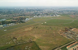
Wilson Airport is an airport in Nairobi, Kenya. It has flights to many regional airports in Kenya while Nairobi's main airport, Jomo Kenyatta International Airport, serves domestic and many international destinations.

<span class="mw-page-title-main">Grumman Gulfstream I</span> Type of aircraft

The Grumman Gulfstream I is a twin-turboprop business aircraft. It first flew on August 14, 1958.

Manda Airport, also called Lamu Airport, is an airport in Kenya.

Nanyuki Airfield is an airport in Nanyuki, Kenya.

<span class="mw-page-title-main">Lewa Airport</span> Airport in Lewa Downs, Kenya

Lewa Airport is an airport in Kenya.

<span class="mw-page-title-main">Los Garzones Airport</span> Airport in Los Garzones

Los Garzones International Airport is an international airport serving the city of Montería in the Córdoba Department of Colombia. It is the only airport in the department that can handle modern jets. On normal days, the airport receives between 20 to 30 takeoffs and landings, and is one of the busiest airports in Colombia's Caribbean region in terms of passenger flow.

<span class="mw-page-title-main">Eldoret International Airport</span> International airport in Eldoret

Eldoret Airport is an international airport in Kenya.

Bungoma Airport is an airport in Kenya.

Mtito Andei Airport is an airport in Kenya.

Moyale Airport, also referred to as Moyale Lower Airport, is an airport located in the town of Moyale, Marsabit County, in the northern part of the Republic of Kenya, at the international border with Ethiopia. Its location is approximately 590 kilometres (370 mi), by air, northeast of Nairobi International Airport, the country's largest civilian airport. The geographic coordinates of this airport are:3° 27' 54.00"N, 39° 6' 18.00"E.

Hola Airport is an airport in Kenya.

Isiolo Airport, also Isiolo International Airport is an airport located in Isiolo, Isiolo County, and Meru County, Kenya.

Kakamega Airport is a small airport in Kenya. It serves the town of Kakamega. At 1,530 metres (5,020 ft) above sea level, the airport has a single asphalt runway which measures 4,200 feet (1,300 m) in length and 49 feet (15 m) in width.

Kisima Airport is an airport in Kenya.

Mandera Airport is an airport in Mandera, Kenya.

Kimwarer Airport is an airport in Kenya.

Kisii Airport is an airport in Kisii County, Kenya.

Kitale Airport is an airport in Kitale, Kenya.

Lokitaung Airport is an airport in Lokitaung, Kenya.

References

  1. "Distance between Busia (Western) and Jomo Kenyatta Airport Nairobi (Nairobi Area) (Kenya)". distancecalculator.globefeed.com. Retrieved 21 August 2018.
  2. "Site Weather Station HKBA in Busia Airport, WE, Kenya". CWOP Weather. Retrieved 21 August 2018.
  3. "Accident Report Summary". Archived from the original on 27 September 2011. Retrieved 25 July 2011.
  4. Ranter, Harro. "ASN Aircraft accident Grumman G-159 Gulfstream I 5Y-EMJ Busia". aviation-safety.net. Retrieved 21 August 2018.

0°27′20″N34°07′48″E / 0.45560°N 34.13000°E / 0.45560; 34.13000