Garoua

Last updated • 3 min readFrom Wikipedia, The Free Encyclopedia
Garoua
City
Marche Garoua Nord Cameroon.jpg
The Market at Garoua
Cameroon adm location map.svg
Red pog.svg
Garoua
Location in Cameroon
Coordinates: 9°18′N13°24′E / 9.300°N 13.400°E / 9.300; 13.400
Country Flag of Cameroon.svg Cameroon
Region North
Department Bénoué
Elevation
249 m (817 ft)
Population
 (2023)
 â€¢ Total2,000,000
Climate Aw

Garoua (also Garua; Fula: 𞤺𞤢𞤪𞤱𞤢, Garwa) is a port city and the capital of the North Region of Cameroon, lying on the Benue River. A thriving centre of the textiles and cotton industries, the city has approximately 1,285,000 inhabitants in 2020, mostly Fulbe/Fulani people. [1]

Contents

History

Garoua was established by the Fulani emir Modibbo Adama in the first half of the 19th century. During the steamship era, it developed into a major river port. [2]

The population of the city was 30,000 in 1967. [3]

Geography

Garoua is situated in northern Cameroon, and lies on the Benue River. [4] It serves as the gateway to Benoue National Park. [5] Neighborhoods include Commercial Centre, Lopere, Quartier de Marouare, Poumpoumre, Roumde Adjia and the northwestern suburb of Yelwa, near Garoua International Airport. [4]

Climate

Garoua has a tropical savanna climate (Köppen Aw), with a wet season and a dry season and the temperature being hot year-round. The average temperature in Garoua ranges from 26.0 Â°C (78.8 Â°F) in December and January, the coolest months, to 33.0 Â°C (91.4 Â°F) in April, the hottest month. The hottest time of year is in March and April, just before the wet season starts. March has the highest average high at 39.8 Â°C (103.6 Â°F), while the highest average low is 26.4 Â°C (79.5 Â°F) in April. August has the lowest average high at 30.7 Â°C (87.3 Â°F), while December has the lowest average low at 17.3 Â°C (63.1 Â°F).

Garoua receives 997.4 millimetres (39.27 in) of rain over 88 precipitation days, with a distinct wet and dry season like most tropical savanna climates. December, January and February receive no precipitation at all. August, the wettest month, receives 247.9 millimetres (9.76 in) of rainfall on average. September has 24 precipitation days, which is the most of any month. Garoua receives 2927.1 hours of sunshine annually on average, with the sunshine being distributed evenly across the year, although it is lower during the wet season.

Climate data for Garoua
MonthJanFebMarAprMayJunJulAugSepOctNovDecYear
Mean daily maximum °C (°F)34.4
(93.9)
37.3
(99.1)
39.8
(103.6)
39.5
(103.1)
36.5
(97.7)
33.2
(91.8)
31.1
(88.0)
30.7
(87.3)
31.5
(88.7)
34.2
(93.6)
36.0
(96.8)
34.8
(94.6)
34.9
(94.8)
Daily mean °C (°F)26.0
(78.8)
28.9
(84.0)
32.2
(90.0)
33.0
(91.4)
30.7
(87.3)
28.2
(82.8)
26.6
(79.9)
26.4
(79.5)
26.7
(80.1)
28.1
(82.6)
27.3
(81.1)
26.0
(78.8)
28.3
(82.9)
Mean daily minimum °C (°F)17.5
(63.5)
20.5
(68.9)
24.7
(76.5)
26.4
(79.5)
24.9
(76.8)
23.2
(73.8)
22.2
(72.0)
22.0
(71.6)
21.9
(71.4)
22.2
(72.0)
19.2
(66.6)
17.3
(63.1)
21.8
(71.2)
Average rainfall mm (inches)0.0
(0.0)
0.0
(0.0)
2.0
(0.08)
44.1
(1.74)
108.4
(4.27)
134.8
(5.31)
205.3
(8.08)
247.9
(9.76)
190.0
(7.48)
63.3
(2.49)
1.6
(0.06)
0.0
(0.0)
997.4
(39.27)
Average rainy days (≥ 1.0 mm)001591114172461088
Mean monthly sunshine hours 275.0252.6260.1245.4256.7224.4194.0187.2204.5261.5279.2286.52,927.1
Source: NOAA [6]

Demographics

In 2005, Garoua had a population of 495,996 people. The city is inhabited by the Fulbe ethnic group. [7] Due to a significant number of Chadian expatriates in the city, there is a Chadian Consulate here. [5]

Economy

As the fourth largest port in Cameroon, [8] Garoua is a major center of trade in the country. [9] It developed as a centre for trade in petroleum, cement, hides, peanuts, and cotton, transported on ships along the Benue River, between Burutu in Nigeria. [2] It has long been a thriving centre of the cotton industry and houses several textile processing facilities and factories. [10] The cotton company Sodecoton has one of its major centres in the city. [11] Leatherwork and fishing are also notable industries. [2]

Sport

Roumdé Adjia Stadium was one of the arenas hosting the 2021 Africa Cup of Nations.

Places of worship

Among the places of worship, there are, predominantly, Muslim mosques. There are also Christian churches and temples: Roman Catholic Archdiocese of Garoua (Catholic Church), Evangelical Church of Cameroon (World Communion of Reformed Churches), Presbyterian Church in Cameroon (World Communion of Reformed Churches), Cameroon Baptist Convention (Baptist World Alliance), Full Gospel Mission Cameroon (Assemblies of God). [12]

Transport

Garoua is served by Garoua International Airport. [13] The United States military uses the airport as a base to conduct unmanned aerial vehicle operations. [14] The city lies on National Highway 1, [4] at a junction of the road between Maroua and Ngaoundéré. [2] The main road leading north through the town and past the airport is called Rue de la Gendarmerie. [4]

Notable people

Related Research Articles

<span class="mw-page-title-main">Yaoundé</span> Capital of Cameroon

Yaoundé is the capital of Cameroon and, with a population of more than 2.8 million, the second-largest city in the country after the port city Douala. It lies in the Centre Region of the nation at an elevation of about 750 metres (2,500 ft) above sea level.

<span class="mw-page-title-main">Fula people</span> Ethnic group in Sahel and West Africa

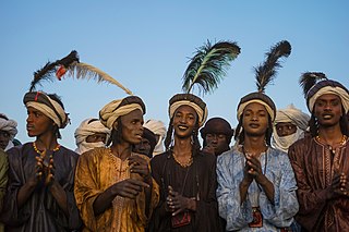
The Fula, Fulani, or Fulɓe people is an ethnic group in Sahara, Sahel and West Africa, widely dispersed across the region. Inhabiting many countries, they live mainly in West Africa and northern parts of Central Africa, South Sudan, Darfur, and regions near the Red Sea coast in Sudan. The approximate number of Fula people is unknown, due to clashing definitions regarding Fula ethnicity. Various estimates put the figure between 25 and 40 million people worldwide.

Yola, meaning 'Great Plain' or 'Vast Plain Land', is a large city, capital city and administrative centre of Adamawa State, Nigeria. It is located on the Benue River, and it has a population of over 336,648 (2010). Yola is split into two parts. The old town of Yola where the Lamido resides is the traditional city and the new city of Jimeta is the administrative and commercial centre. They are generally referred to as Yola.

<span class="mw-page-title-main">Moundou</span> Place in Logone Occidental Region, Chad

Moundou is the second-largest city in Chad and is the capital of the region of Logone Occidental.

Sarh, formerly French colonial Fort Archambault, is the capital of the Moyen-Chari Region and of the Department of Barh Köh in Chad.

<span class="mw-page-title-main">Adamawa Region</span> Region of Cameroon

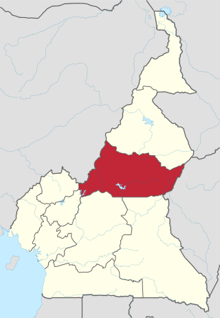
The Adamawa Region is a constituent region of the Republic of Cameroon. It borders the Centre and East regions to the south, the Northwest and West regions to the southwest, Nigeria to the west, the Central African Republic (CAR) to the east, and the North Region to the north.

<span class="mw-page-title-main">Ngaoundéré</span> Place in Adamawa, Cameroon

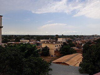
Ngaoundéré or N'Gaoundéré is the capital of the Adamawa Region of Cameroon. It had a population of 152,700 at the 2005 census. According to the film Les Mairuuwas – Maitre de l'eau produced by the University of Tromsø, the population has rapidly risen to 1,000,000 owing to mass immigration from the Central African Republic and the perceived danger from Boko Haram in northern Cameroon.

<span class="mw-page-title-main">North Region (Cameroon)</span> Region of Cameroon

The North Region makes up 66,090 km2 of the northern half of The Republic of Cameroon. Neighbouring territories include the Far North Region to the north, the Adamawa Region to the south, Nigeria to the west, Chad to the east, and Central African Republic to the southeast. The city of Garoua is both the political and industrial capital. Garoua is Cameroon's third largest port, despite the fact that the Bénoué River upon which it relies is only navigable for short periods of the year.

Adama ɓii Ardo Hassana, more commonly known as Modibbo Adama, was a Fulani scholar who hailed from the Yillaga (Yirlaɓe) clan originaire des Hosobhes du douentza. He led a jihad into the region of Fombina and established the emirate of Fombina, also known as Adamawa.

<span class="mw-page-title-main">Malakal</span> City in Upper Nile State, South Sudan

Malakal is a city in South Sudan, serving as the capital of Upper Nile State, South Sudan, along the White Nile River. It also serves as the headquarter of Malakal county and it used to be the headquarter of Upper Nile Region from the 1970s to the late 1990s.

<span class="mw-page-title-main">Mokolo</span> Place in Far North Region, Cameroon

Mokolo is the departmental capital and largest city of the Mayo-Tsanaga department, in the Far North Province of Cameroon. It is the fourth largest city in the Far North Province, after Maroua, Yagoua, and Kousséri. It is located in the Mandara Mountains that run along the Cameroonian-Nigerian border.

<span class="mw-page-title-main">Far North Region (Cameroon)</span> Region of Cameroon

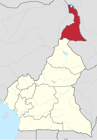
The Far North Region, also known as the Extreme North Region, is the northernmost and most populous constituent province of the Republic of Cameroon. It borders the North Region to the south, Chad to the east, and Nigeria to the west. The capital is Maroua.

<span class="mw-page-title-main">Cameroon line</span> Chain of volcanoes in the Gulf of Guinea

The Cameroon line is a 1,600 km (1,000 mi) long chain of volcanoes that includes islands in the Gulf of Guinea and mountains on the African mainland, from Mount Cameroon on the coast towards Lake Chad on the northeast. They form a natural border between eastern Nigeria and the West Region of Cameroon. The islands, which span the equator, have tropical climates and are home to many unique plant and bird species. The mainland mountain regions are much cooler than the surrounding lowlands, and also contain unique and ecologically important environments.

The African Men's Olympic Qualifiers were held to determine the African national teams for under 23 which participated at the 2008 Summer Olympics football tournament held in Beijing.

<span class="mw-page-title-main">Batouri</span> Place in East, Cameroon

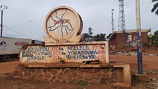
Batouri is a town and commune in the East Province of Cameroon. It is the second largest municipality in the province after the provincial capital Bertoua. It is located on the main road connecting Bertoua to the Central African Republic and to the Cameroonian town of Yokadouma. It had an estimated 33,500 inhabitants as of 2012.

<span class="mw-page-title-main">Tropical monsoon climate</span> Climate subtype in the Köppen climate classification system

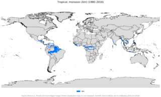
An area of tropical monsoon climate is a tropical climate subtype that corresponds to the Köppen climate classification category Am. Tropical monsoon climates have monthly mean temperatures above 18 Â°C (64 Â°F) in every month of the year and a dry season. The tropical monsoon climate is the intermediate climate between the wet AF and the drier Aw.

<span class="mw-page-title-main">Girei</span> LGA and town in Adamawa State, Nigeria

Girei is a town and local government area of Adamawa State, Nigeria. It lies on the Benue River. The dominant tribe in the area are the Fulɓe or Fulani; however, a substantial number of Bwatiye also dwell in villages such as Greng, Notable, and Labondo within the Girei local government area. The primary occupation of the people in the area is farming and cattle rearing. Girei is also a home to Radio Gotel.

<span class="mw-page-title-main">Adamawa Wars</span>

The Adamawa Wars (1899–1907) were initially a series of military expeditions and border conflicts between the German Schutztruppe in Kamerun and the Fula Sunni Muslim states and tribes that were a part of the Sokoto Empire, particularly the Emirate of Adamawa in the northern half of the region. After these territories were annexed major resistance continued for years and several uprisings occurred.

<span class="mw-page-title-main">2021 Africa Cup of Nations</span> Continental football competition

The 2021 Africa Cup of Nations, known as the TotalEnergies2021 Africa Cup of Nations for sponsorship reasons, was the 33rd edition of the Africa Cup of Nations, the biennial international men's football championship of Africa organised by the Confederation of African Football (CAF). The tournament was hosted by Cameroon, and took place from 9 January to 6 February 2022.

Goggo Addi was a Cameroonian storyteller who performed in the Fula language. She hosted storytelling events in the country for several decades, and from 1985 to 1989 she consented to have her stories recorded and transcribed by the researcher Ursula Baumgardt, contributing significantly to perpetuating this West African oral tradition.

References

  1. ↑ "Population of Cities in Cameroon (2018)". worldpopulationreview.com. Retrieved 2018-09-06.
  2. 1 2 3 4 "Garoua". Encyclopædia Britannica. Retrieved 29 October 2016.
  3. ↑ Mark Dike DeLancey, Rebecca Neh Mbuh, Mark W. Delancey, Historical Dictionary of the Republic of Cameroon, Scarecrow Press, USA, 2010, p. 189
  4. 1 2 3 4 Google (29 October 2016). "Garoua" (Map). Google Maps . Google. Retrieved 29 October 2016.
  5. 1 2 Ham, Anthony (2009). West Africa. Lonely Planet. p. 207. ISBN   978-1-74104-821-6.
  6. ↑ "Garoua Climate Normals 1961–1990". National Oceanic and Atmospheric Administration . Retrieved March 8, 2015.
  7. ↑ Drønen, Tomas Sundnes (31 August 2009). Communication and Conversion in Northern Cameroon: The Dii People and Norwegian Missionaries, 1934-1960. BRILL. p. 40. ISBN   978-90-474-3098-8.
  8. ↑ Trillo, Richard (2 June 2008). The Rough Guide to West Africa. Rough Guides Limited. p. 3028. ISBN   978-1-4053-8068-3.
  9. ↑ Georgia (Republic) Export-Import Trade and Business Directory. International Business Publications. October 2005. p. 97. ISBN   978-0-7397-3267-0.
  10. ↑ Ndenecho, Emmanuel Neba (2011). Decentralisation and Spatial Rural Development Planning in Cameroon. African Books Collective. p. 76. ISBN   978-9956-717-66-8.
  11. ↑ Raimond, Christine (8 October 2013). Ressources vivrières et choix alimentaires dans le bassin du lac Tchad. IRD Editions. p. 202. ISBN   978-2-7099-1576-2.
  12. ↑ J. Gordon Melton, Martin Baumann, ‘‘Religions of the World: A Comprehensive Encyclopedia of Beliefs and Practices’’, ABC-CLIO, USA, 2010, p. 484-486
  13. ↑ Africa Review 2003/04: The Economic and Business Report. Kogan Page Publishers. 2003. p. 44. ISBN   978-0-7494-4065-7.
  14. ↑ Hammer, Joshua (2016-02-25). "Hunting Boko Haram: The U.S. Extends Its Drone War Deeper Into Africa With Secretive Base". The Intercept.
  15. ↑ Baumgardt, Ursula (2000). Une conteuse peule et son répertoire : Goggo Addi de Garoua, Cameroun : textes et analyses. Goggo Addi. Paris: Karthala. ISBN   2-84586-104-4. OCLC   45647204.
  16. ↑ Appiah, Anthony; Gates, Henry Louis (2010). Encyclopedia of Africa. Oxford University Press. p. 73. ISBN   978-0-19-533770-9.

09°18′N13°24′E / 9.300°N 13.400°E / 9.300; 13.400