The Quad Cities is a region of five cities in the U.S. states of Iowa and Illinois: Davenport and Bettendorf in southeastern Iowa, and Rock Island, Moline and East Moline in northwestern Illinois. These cities are the center of the Quad Cities metropolitan area, a region within the Mississippi River Valley, which as of 2023, had a population estimate of 467,817 and a Combined Statistical Area (CSA) population of 474,019, making it the 90th-largest CSA in the nation.

The Julien Dubuque Bridge is a bridge over the Mississippi River that connects Dubuque, Iowa and East Dubuque, Illinois. The bridge is part of U.S. Route 20 (US 20). It is one of two automobile bridges over the Mississippi in the area, and is listed in the National Register of Historic Places.

The Fred Schwengel Memorial Bridge is a 4-lane steel girder bridge that carries Interstate 80 across the Mississippi River between LeClaire, Iowa and Rapids City, Illinois. The bridge is named for Fred Schwengel, a former U.S. Representative from Davenport, Iowa and one of the driving forces behind the Interstate Highway Act. The structure was designed by the Iowa State Highway Commission, and was built by the Industrial Construction Company of Minneapolis (contractor), Gould Construction Company of Davenport, and Roy Ryan & Sons of Evanston, Indiana who was responsible for the substructure. The bridge opened on October 27, 1966, and is maintained by the Illinois Department of Transportation. It underwent a major rehabilitation project in 1996.
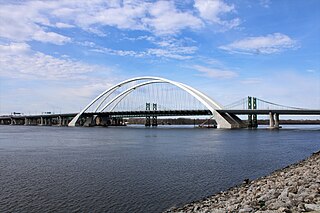
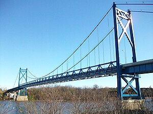
The Interstate 74 Bridge, officially known as the Iowa-Illinois Memorial Bridge, and often called The Twin Bridges, or the I-74 Bridge, are basket-handle, through arch twin bridges that carry Interstate 74 across the Mississippi River and connect Bettendorf, Iowa, and Moline, Illinois. It is located near the geographic center of the Quad Cities. They replace two suspension bridges opened to traffic in 1935 and 1959, both of which had become obsolete by the 1990s.

The McKinley Bridge is a steel truss bridge across the Mississippi River. It connects northern portions of the city of St. Louis, Missouri with Venice, Illinois. It opened in 1910 and was taken out of service on October 30, 2001. The bridge was reopened for pedestrian and bicyclists on November 17, 2007, with a grand re-opening celebration. Since December 2007, McKinley has been open to vehicular traffic as well. It is accessible from Illinois Route 3 in Illinois and from the intersection of Salisbury and North 9th Street in the city of St. Louis. The bridge carried both railroad and vehicular traffic across the Mississippi River for decades. By 1978, the railroad line over the span was closed, and an additional set of lanes was opened for vehicles in the inner roadway.

Forgottonia, also spelled Forgotonia, is the name given to a 16-county region in Western Illinois in the late 1960s and early 1970s. This geographic region forms the distinctive western bulge of Illinois that is roughly equivalent to "The Tract", the Illinois portion of the Military Tract of 1812, along and west of the Fourth Principal Meridian. Since this wedge-shaped region lies between the Illinois and Mississippi rivers, it has historically been isolated from the eastern portion of Central Illinois.
The Great River Bridge is an asymmetrical, single tower cable-stayed bridge over the Mississippi River. It carries U.S. Route 34 from Burlington, Iowa to the town of Gulfport, Illinois.

The Mark Morris Memorial Bridge is a 2 lane truss bridge across the Mississippi River in the United States. It connects the cities of Clinton, Iowa and Fulton, Illinois. The bridge may also be known as the Lyons-Fulton Bridge, which was the name of a predecessor bridge and the name listed on the USGS topographical map. The town of Lyons, Iowa, was annexed to Clinton in 1895, but the northern end of the city is still referred to as Lyons. The bridge is the terminus of both Iowa Highway 136 and Illinois Route 136. The 1975 bridge was named in memory Mark Morris, a long time member of the City of Clinton Bridge Commission who died in 1972. Morris was instrumental in the construction of the 1975 bridge and the City of Clinton Bridge Commission named it in his honor.

The Fort Madison Toll Bridge is a tolled, double-decked swinging truss bridge over the Mississippi River that connects Fort Madison, Iowa, and unincorporated Niota, Illinois. A double-track railway occupies the lower deck of the bridge, while two lanes of road traffic are carried on the upper deck. The bridge is about 1 mile (1.6 km) long with a swing span of 525 feet (160 m), and was the longest and largest double-deck swing-span bridge in the world when constructed in 1927. It replaced an inadequate combination roadway/single-track bridge completed in 1887. The main river crossing consists of four 270-foot (82 m) Baltimore through truss spans and a swing span made of two equal arms, 266 feet (81 m) long. In 1999, it was listed in the National Register of Historic Places under the title, Fort Madison Bridge, ID number 99001035. It was also documented as survey number IA-62 by the Historic American Engineering Record, archived at the Library of Congress. Construction and photographic details were recorded at the time in Scientific American magazine.
The Norbert F. Beckey Bridge carries Iowa Highway 92 and Illinois Route 92 across the Mississippi River between Muscatine, Iowa and Rock Island County, Illinois, United States.

The Sergeant John F. Baker Jr. Bridge, also known as the Baker Bridge or Interstate 280 Bridge, carries Interstate 280 (I-280) across the Mississippi River between Davenport, Iowa, and Rock Island, Illinois. The bridge opened in 1973 with a blue and yellow color scheme, thought to be unique in the state. In 2007, it was repainted all blue. On July 30, 2010, the bridge was officially named the Sergeant John F. Baker Jr. Bridge.

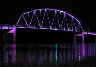
The Government Bridge or Arsenal Bridge spans the Mississippi River, connecting Rock Island, Illinois and Davenport, Iowa. The Iowa Interstate Railroad uses the upper deck of the bridge for its ex-Chicago and Rock Island Railroad route between Council Bluffs, Iowa and Chicago, Illinois. The lower deck carries automobile traffic between the two cities. It is located near Upper Mississippi Mile Marker 483, adjacent to the Mississippi River Lock and Dam No. 15. The current structure is the fourth at this location. The bridges all were built with a swing section to accommodate traffic navigating the river.

The Clinton Railroad Bridge, also called the Chicago and Northwestern Railway Bridge or more simply the Clinton Bridge, is a bridge that carries double tracked rail lines across the Mississippi River between Clinton, Iowa, and Fulton (Albany), Illinois. The bridge is a truss bridge with a swing span crossing the main river channel and is adjacent to the Gateway Bridge. The original bridge was constructed in 1858, and the first train crossed the bridge on January 19, 1860. The bridge was the second railroad crossing over the Mississippi River. In 1870, the bridge was declared a post route, therefore stopping the occupation of steamboats and approval of railroads. From 1859 to 1908, the mileage in operation increased from 28,789 to 229,230, prompting the Chicago and North Western Railway to replace the bridge with a new structure in 1900.

U.S. Route 30 (US 30) is an east–west arterial surface road in northern Illinois. It runs from across the Mississippi River from Clinton, Iowa, to Lynwood at the Indiana state line. This is a distance of 153.79 miles (247.50 km).

Illinois Route 136 (IL 136) is an east–west state highway in northwestern Illinois. It runs from the Mark Morris Memorial Bridge over the Mississippi River, connecting to Iowa Highway 136 in Clinton, Iowa, east to U.S. Route 30 (US 30) east of Fulton. This is a distance of 3.22 miles (5.18 km).
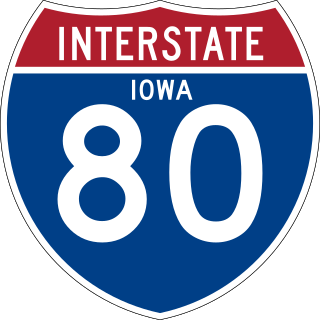
Interstate 80 (I-80) is a transcontinental Interstate Highway in the United States, stretching from San Francisco, California, to Teaneck, New Jersey. In Iowa, the highway travels west to east through the center of the state. It enters the state at the Missouri River in Council Bluffs and heads east through the southern Iowa drift plain. In the Des Moines metropolitan area, I-80 meets up with I-35 and the two routes bypass Des Moines together. On the northern side of Des Moines, the Interstates split and I-80 continues east. In eastern Iowa, it provides access to the University of Iowa in Iowa City. Northwest of the Quad Cities in Walcott is Iowa 80, the world's largest truck stop. I-80 passes along the northern edge of Davenport and Bettendorf and leaves Iowa via the Fred Schwengel Memorial Bridge over the Mississippi River into Illinois.

U.S. Highway 67 (US 67) is a U.S. Highway in extreme eastern Iowa. The route begins in Davenport at the Rock Island Centennial Bridge where it crosses the Mississippi River and ends at an intersection with US 52 and Iowa Highway 64 (Iowa 64) west of Sabula. It passes through Bettendorf, Le Claire, and Clinton. Except for Folletts, every community which US 67 enters sits along the Mississippi River. As such, most of the route is part of the Great River Road, an All-American Road.

Interstate 74 (I-74) is the central freeway through the Iowa Quad Cities. It roughly divides Davenport to the west and Bettendorf to the east. The Interstate Highway begins at an interchange with I-80 at the northeastern edge of Davenport and continues into Illinois at the Mississippi River by crossing the I-74 Bridge. The freeway was built in stages during the late 1960s and early 1970s.

U.S. Highway 61 (US 61) is a United States Highway that serves eastern Iowa. It enters the state from Missouri near Keokuk with US 136. North of Keokuk, it is overlapped by US 218 for a few miles. It the follows the course of the Mississippi River past Montrose and Fort Madison. It meets US 34 at Burlington. It passes through Wapello and bypasses Muscatine and Blue Grass on its way toward Davenport. There, it follows Interstate 280 (I-280) and I-80 around the Quad Cities. North of Davenport, it follows a freeway north toward DeWitt where it meets US 30. The highway continues north through Maquoketa and reaches the Dubuque area. There it is joined by US 151 and briefly by US 52. The two highways enter the downtown area on an expressway. Due to the proximity of the Mississippi River and railroad tracks that lie between, the routes have an indirect junction with US 20. The two highways leave the state and enter Wisconsin about one-half mile (800 m) north of the Illinois–Wisconsin state line.

The Dale Gardner Veterans Memorial Bridge, often referred to as the New Savanna-Sabula Bridge, or by the same name as its predecessor, the Savanna-Sabula Bridge, is a steel tied-arch that carries U.S. Route 52 (US 52) across the Mississippi River. It connects the city of Savanna, Illinois, with the island city of Sabula, Iowa. Construction on the span began in 2016 and it opened on November 17, 2017. It was erected by Bumpy's Steel Erection of East St. Louis, Illinois and Edward Kraemer & Sons of Plain, Wisconsin. The bridge replaced the Savanna–Sabula Bridge, which was located a few yards to the north.