Related Research Articles

Lake Mathews is a large reservoir in Riverside County, California, located in the Cajalco Canyon in the foothills of the Temescal Mountains. It is the western terminus for the Colorado River Aqueduct that provides much of the water used by the cities and water districts of the Metropolitan Water District of Southern California. The reservoir is fenced and closed to all public access. The lake is near the Riverside community of Lake Hills, and is skirted by Cajalco Road on the south, El Sobrante Road on the north and east, and La Sierra Avenue on the west. La Sierra Avenue traverses the top of the west dike.
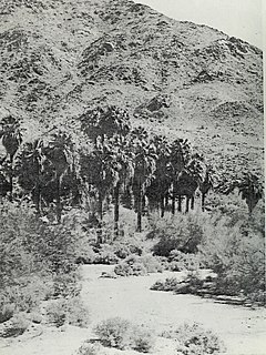
Corn Springs is a palm oasis situated in the Chuckwalla Mountains of the Colorado Desert in Riverside County, California, United States, seventeen miles southeast of Desert Center. Native Americans relied on the springs, and they engraved many petroglyphs on the rocks in the area. In the late 19th century, miners in the area also relied on the springs, and they established the Corn Springs Mining District in 1897.

The Temecula Valley is a graben rift valley in western Riverside County, California.

Temescal Creek is an approximately 29-mile-long (47 km) watercourse in Riverside County, in the U.S. state of California. Flowing primarily in a northwestern direction, it connects Lake Elsinore with the Santa Ana River. It drains the eastern slopes of the Santa Ana Mountains on its left and on its right the western slopes of the Temescal Mountains along its length. With a drainage basin of about 1,000 square miles (2,600 km2), it is the largest tributary of the Santa Ana River, hydrologically connecting the 720-square-mile (1,900 km2) San Jacinto River and Lake Elsinore watersheds to the rest of the Santa Ana watershed. However, flowing through an arid rain shadow zone of the Santa Ana Mountains, and with diversion of ground water for human use, the creek today is ephemeral for most of its length, except for runoff from housing developments and agricultural return flows.

Democrat, originally Democrat Hill, is a former settlement in Nevada County, California. It lay on the Chalk Bluff ridge, about 1 mile south of what is now Highway 20, about 6 miles southeast of the town of Washington and about 1 mile east of Remington Hill. Its elevation was 4170 feet. It lay on a gold bearing gravel channel on the Chalk Bluff Ridge, which lies between Steephollow and Greenhorn Creeks, tributaries of the Bear River. As the channel runs southwest, it joins a major channel running from the San Juan Ridge easterly through Red Dog and You Bet into Placer County.

Alberhill is an unincorporated community in Riverside County, California. Alberhill is located on 5.5 miles (8.9 km) northwest of Lake Elsinore. It lies at an elevation of 1234 feet. Alberhill was named after C.H. Albers and James and George Hill.
Willard is a former populated place in Riverside County, California. It was located at the west corner of Lake Elsinore. It had its own post office located in the former Laguna Butterfield Stage Station, on at 32912 Macy Avenue, from November 18, 1898, until September 30, 1902, when it was absorbed by the Elsinore post office. Willard was later incorporated into the City of Lake Elsinore. The old post office was torn down in 1964. Today three palm trees still grow in front of the site along Macy Avenue in front of the property.
Leon, now a ghost town, was a gold mining town in northern San Diego County from the 1880s, named for the Leon Mine that lay on a hill to the northwest of the town. Leon became part of southwestern Riverside County in 1893. Leon had its own post office from May 4, 1888 until July 31, 1911 when its post office was moved to Perris, California.
The Elsinore Trough is a graben rift valley in Riverside County, southern California. It is created by the Elsinore Fault Zone.

Temescal Mountains, formerly the Sierra Temescal, are one of the northernmost mountain ranges of the Peninsular Ranges in western Riverside County, in Southern California in the United States. They extend for approximately 25 mi (40 km) southeast of the Santa Ana River east of the Elsinore Fault Zone to the Temecula Basin and form the western edge of the Perris Block.
Temescal Valley in California is a graben rift valley in western Riverside County, California, a part of the Elsinore Trough. The Elsinore Trough is a graben between the Santa Ana Mountain Block to the southwest and the Perris Block on the northeast. It is a complex graben, divided lengthwise into several smaller sections by transverse faults. The Temescal Valley is one of these graben, at the northern end of the trough. The Temescal Valley graben is bounded northeast side by the Lee Lake longitudinal fault and similarly on the southeast by the Glen Ivy Fault.
Elsinore Valley is a graben rift valley in western Riverside County, California, a part of the Elsinore Trough. The Elsinore Valley is a graben between the Santa Ana Block to the southwest and the Perris Block on the northeast. It is a complex graben, divided lengthwise into several smaller sections by transverse faults.

The Clevelin Hills are a range of hills in the Peninsular Ranges System, within the Temescal Mountains in western Riverside County, in southern California.
The Perris Block is the central block of three major fault-bounded blocks of the northern part of the Peninsular Ranges. The Perris Block lies between the Santa Ana Block to the west and the San Jacinto Block to the east. The Perris Block, was named by Walter A. English in 1925 for the city of Perris, located near the center of the block.
Wolf Valley is a graben rift valley in the Elsinore Trough, in western Riverside County, California.
Gavilan Hills, sometimes called the Gavilan Mountains, are a range of the Temescal Mountains, in Riverside County, California. The name given them came from local New Mexican and Californio miners of the mountains and Gavilan Plateau. In Spanish Gavilan, means "sparrow hawk".
Gavilan Mining District is a gold mining district 6 miles west of Perris, California and Gavilan Hills and east of Gavilan Peak on the Gavilan Plateau in Riverside County, California. It includes only 2 mines: the Ida Leona Mine and the Gavilan Mine located within yards of each other.
Cajalco Canyon Creek is an ephemeral stream that flows through Cajalco Canyon in the Temescal Mountains of Riverside County, California, United States. It is a tributary to Temescal Wash, itself a tributary to the Santa Ana River. Cajalco is thought to be a Hispanic spelling of the word for "quail" in the languages of the Luiseño and Cahuilla who lived in the area. The meaning of the word Cajalco is an anagram meaning California Jalisco Land Company of Los Angeles
Lee Lake, is a reservoir created by the Lee Lake 818-002 Dam across Temescal Creek, in Riverside County, California. It lies at an elevation of 1,122 feet (342 m).
Rome Hill, also called St. Davids Hill, is a small summit at the southeast corner of Lake Elsinore. It lies at an elevation of 1444 feet / 440 meters.
References
- ↑ U.S. Geological Survey Geographic Names Information System: Gavilan Plateau
- ↑ Lech, Steve, Pioneers of Riverside County: The Spanish, Mexican and Early American Periods, The History Press, Charleston, SC, 2012
- ↑ Jane Davies Gunther, Riverside County, California, Place Names: Their Origins and Their Stories, J.D. Gunther, 1984
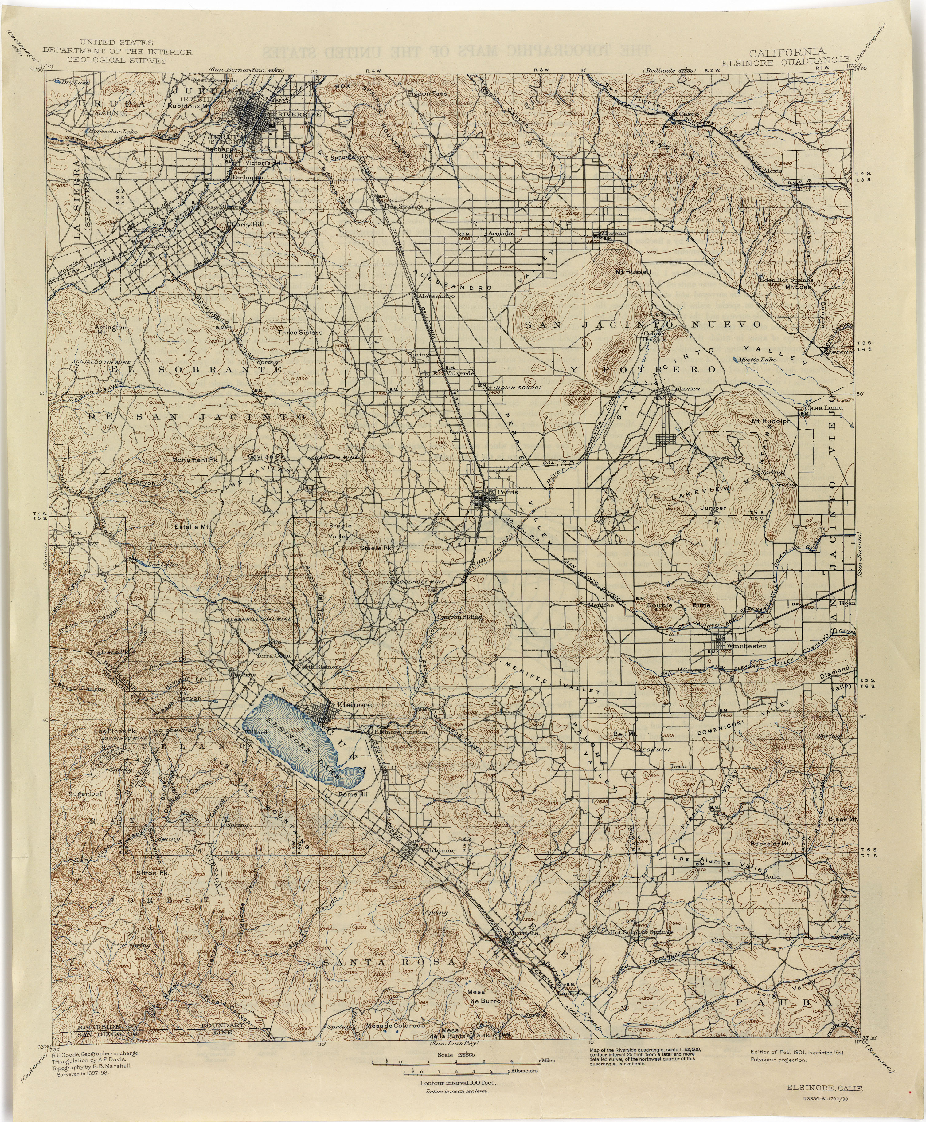
- ↑ Elsinore, California Quadrangle Topographic Map, United States Department of Interior, Geological Survey, 1898, 1901 edition, 1941 reprint
Coordinates: 33°47′43″N117°22′29″W / 33.79528°N 117.37472°W
| This Riverside County, California-related article is a stub. You can help Wikipedia by expanding it. |