Related Research Articles

Lake Elsinore is a city in western Riverside County, California, United States. Established as a city in 1888, it is on the shore of Lake Elsinore, a natural freshwater lake about 3,000 acres (1,200 ha) in size. The city has grown from a small resort town in the late 19th and early 20th centuries to a suburban city with over 70,000 residents.

Lake Elsinore is a natural freshwater lake in Riverside County, California, United States, located east of the Santa Ana Mountains and fed by the San Jacinto River. Originally named Laguna Grande by Spanish explorers, it was renamed for the town of Elsinore, established on its northeastern shore on April 9, 1888.

The Santa Ana Mountains are a short peninsular mountain range along the coast of Southern California in the United States. They extend for approximately 61 miles (98 km) southeast of the Los Angeles Basin largely along the border between Orange and Riverside counties.

The Temecula Valley is a graben rift valley in western Riverside County, California.
Rancho La Laguna was a 13,339-acre (53.98 km2) Mexican land grant in present-day Riverside County, California given in 1844 by Governor Manuel Micheltorena to Julian Manriquez. The rancho lands are included in the present day city of Lake Elsinore and Wildomar. At the time of the US Patent, Rancho Laguna was a part of San Diego County. The County of Riverside was created by the California Legislature in 1893 by taking land from both San Bernardino and San Diego Counties.

Temescal Creek is an approximately 29-mile-long (47 km) watercourse in Riverside County, in the U.S. state of California. Flowing primarily in a northwestern direction, it connects Lake Elsinore with the Santa Ana River. It drains the eastern slopes of the Santa Ana Mountains on its left and on its right the western slopes of the Temescal Mountains along its length. With a drainage basin of about 1,000 square miles (2,600 km2), it is the largest tributary of the Santa Ana River, hydrologically connecting the 720-square-mile (1,900 km2) San Jacinto River and Lake Elsinore watersheds to the rest of the Santa Ana watershed. However, flowing through an arid rain shadow zone of the Santa Ana Mountains, and with diversion of ground water for human use, the creek today is ephemeral for most of its length, except for runoff from housing developments and agricultural return flows.

Rancho Temescal was a farming outpost of Mission San Luis Rey de Francia, one of the 21 Franciscan missions established in California by Spain during the late 18th and early 19th centuries. The Mission was located on the coast where Oceanside, California is today. The Rancho was settled in 1819 by Leandro Serrano, and became the first non-native settlement within the boundaries of what would become Riverside County, California.
Gavilán, meaning sparrowhawk in Spanish, may refer to:
Alberhill is an unincorporated community in Riverside County, California. Alberhill is located 5.5 miles (8.9 km) northwest of Lake Elsinore. It lies at an elevation of 1234 feet. Alberhill was named after C.H. Albers and James and George Hill.
The Elsinore Trough is a graben rift valley in Riverside County, southern California. It is created by the Elsinore Fault Zone.
Temescal Mountains, also known as the Sierra Temescal, are one of the northernmost mountain ranges of the Peninsular Ranges in western Riverside County, in Southern California in the United States. They extend for approximately 25 mi (40 km) southeast of the Santa Ana River east of the Elsinore Fault Zone to the Temecula Basin and form the western edge of the Perris Block.
Temescal Valley in California is a graben rift valley in western Riverside County, California, a part of the Elsinore Trough. The Elsinore Trough is a graben between the Santa Ana Mountain Block to the southwest and the Perris Block on the northeast. It is a complex graben, divided lengthwise into several smaller sections by transverse faults. The Temescal Valley is one of these graben, at the northern end of the trough. The Temescal Valley graben is bounded northeast side by the Lee Lake longitudinal fault and similarly on the southeast by the Glen Ivy Fault.
Elsinore Valley is a graben rift valley in western Riverside County, California, a part of the Elsinore Trough. The Elsinore Valley is a graben between the Santa Ana Block to the southwest and the Perris Block on the northeast. It is a complex graben, divided lengthwise into several smaller sections by transverse faults.

The Clevelin Hills are a range of hills in the Peninsular Ranges System, within the Temescal Mountains in western Riverside County, in southern California.
The Perris Block is the central block of three major fault-bounded blocks of the northern part of the Peninsular Ranges. The Perris Block lies between the Santa Ana Block to the west and the San Jacinto Block to the east. The Perris Block, was named by Walter A. English in 1925 for the city of Perris, located near the center of the block.
Warm Springs Valley is a valley located within the city of Lake Elsinore in Riverside County, California. It lies between the main body of the Temescal Mountains to the north, east and south and the Clevelin Hills to the west. The valley was named for the warm springs that used to be found flowing there.
Gavilan Mining District is a gold mining district 6 miles west of Perris, California and Gavilan Hills and east of Gavilan Peak on the Gavilan Plateau in Riverside County, California. It includes only 2 mines: the Ida Leona Mine and the Gavilan Mine located within yards of each other.
Gavilan Plateau is a plateau in Riverside County, California. It lies at an elevation of 2083 feet on the north slope of the Temescal Mountains overlooking the Cajalco Valley south of Riverside, California.
Cajalco Canyon Creek is an ephemeral stream that flows through Cajalco Canyon in the Temescal Mountains of Riverside County, California, United States. It is a tributary to Temescal Wash, itself a tributary to the Santa Ana River. Cajalco is thought to be a Hispanic spelling of the word for "quail" in the languages of the Luiseño and Cahuilla who lived in the area. The word Cajalco is an acronym- California Jalisco Land Company of Los Angeles

Walker Canyon is a canyon in the Temescal Mountains, in Riverside County, California. It lies divides Alberhill Summit, on the west and the balance of the range to its east. Temescal Creek flows northward through the canyon from where it heads at 33°42′33″N117°21′43″W in Warm Springs Valley into the upper reach of the Temescal Valley near Alberhill, California. Coming from the Temescal Mountains to the east, Gavilan Wash has its confluence with Walker Canyon near mid way along its length, and Alberhill Canyon has its confluence with Walker Canyon at its mouth.
References
- ↑ The Gavilan Hills were first shown as Gavilan Mountains on the 1892 Beasley Map of San Bernardino County.
- ↑ USGS Map: Steele Peak, CA, Temescal Mountains Summit 2557, Elevation: 2,557 feet, 33°47′53″N117°19′23″W / 33.79806°N 117.32306°W
- ↑ U.S. Geological Survey Geographic Names Information System: Steele Peak, Elevation: 2520 feet
- ↑ Lech, Steve, Pioneers of Riverside County: The Spanish, Mexican and Early American Periods, The History Press, Charleston, SC, 2012
- ↑ Jane Davies Gunther, Riverside County, California, Place Names: Their Origins and Their Stories, J.D. Gunther, 1984
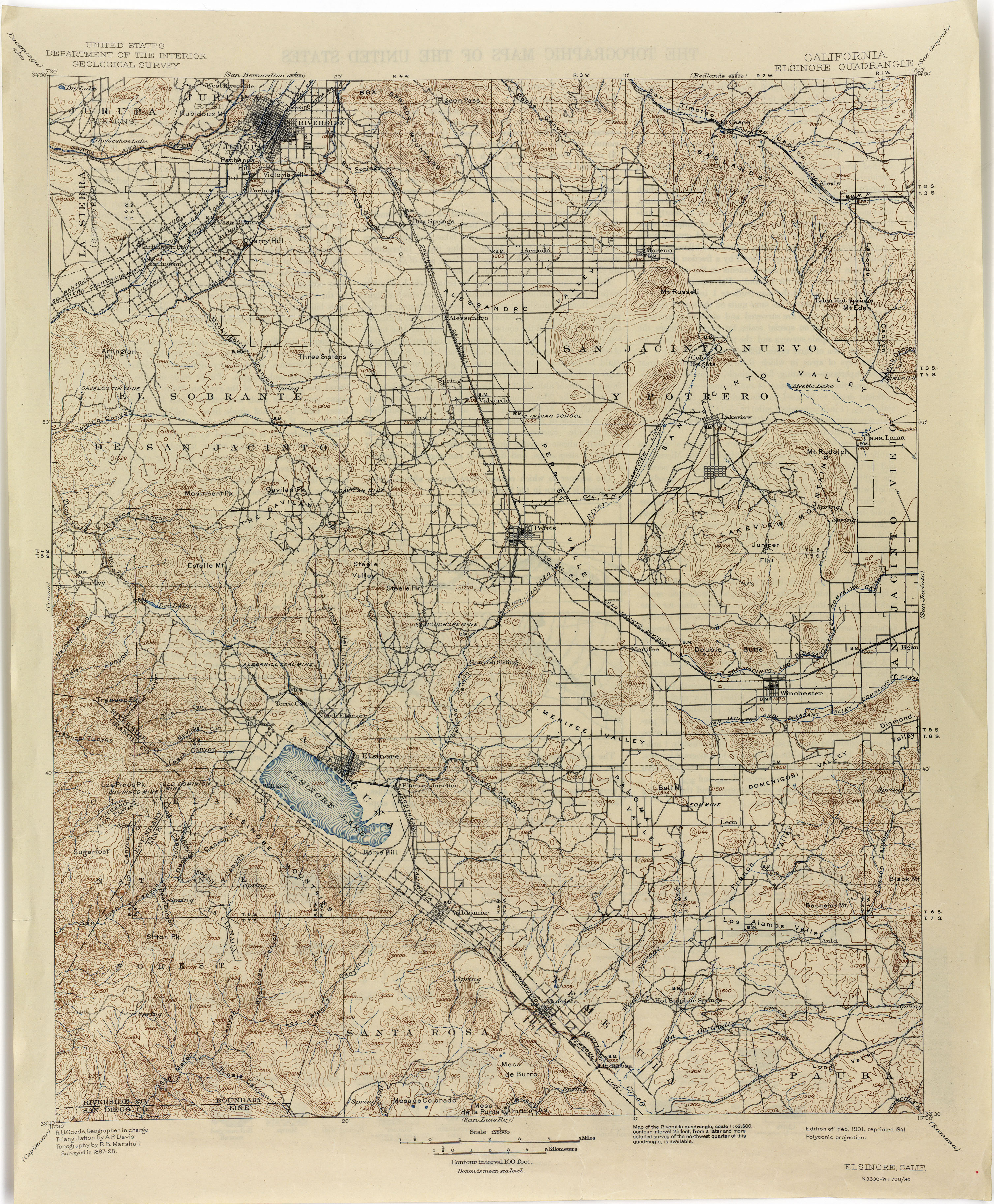
- ↑ Elsinore, California Quadrangle Topographic Map, United States Department of Interior, Geological Survey, 1898, 1901 edition, 1941 reprint
- ↑ Kristeen Penrod and other authors, A Conservation Alternative for the Management of the Four Southern California National Forests, Los Padres, Angeles, San Bernardino, Cleveland, Center for Biological Diversity, April 2002; p. 157-158