
Glen Burnie is an unincorporated town and census-designated place (CDP) in Anne Arundel County, Maryland, United States. It is a suburb of Baltimore. The population was 72,891 at the 2020 census.

A continuous flow intersection (CFI), also called a crossover displaced left-turn, is an alternative design for an at-grade road junction. Vehicles attempting to turn across the opposing direction of traffic cross before they enter the intersection. No left turn signal in the intersection is then necessary. Instead, vehicles traveling in both directions can proceed, including through vehicles and those turning right or left, when a generic traffic signal/stop sign permits.

Mondawmin is a neighborhood located in the Western district of Baltimore, Maryland, United States. The neighborhood is surrounded by Druid Hill Park, the Whitelock Community, and Lower Park Heights. Included within its boundaries are Frederick Douglass High School, and Mondawmin Mall. The Baltimore Metro Subway serves the neighborhood, with a station at Mondawmin Mall that is also a hub for many bus routes.

Maryland Route 150 (MD 150) is a state highway in the U.S. state of Maryland. Known for most of its length as either Eastern Avenue or Eastern Boulevard, the highway runs 13.01 miles (20.94 km) from U.S. Route 40 (US 40) in Baltimore east to Graces Quarters Road in Chase in eastern Baltimore County. MD 150 connects Baltimore with its southeastern suburbs of Dundalk, Essex, and Middle River. The state highway also links those communities with Interstate 95 (I-95), I-695, I-895, and Martin State Airport. MD 150 was constructed from Baltimore to Middle River and in Chase in the mid-1920s. The road was completed through Middle River in the early 1930s. Between 1942 and 1944, MD 150 was reconstructed as a four-lane divided highway with interchanges to improve access between Baltimore and the Glenn L. Martin Company aircraft manufacturing plant in Middle River. The highway has followed several routes since it was extended west into the city of Baltimore in the mid-1940s; the present route in East Baltimore was established shortly after 2000.

Westport is a neighborhood in south Baltimore, Maryland. Westport is a majority African-American neighborhood that has struggled with crime, housing abandonment, and unemployment in the past decade. The neighborhood is bordered by the Middle Branch of the Patapsco River on the east, the city neighborhoods of Cherry Hill, Brooklyn and the southwestern Baltimore County community of Lansdowne to the southwest, Hollins Ferry Road and the Mount Winans and Lakeland neighborhoods to the west, and Interstate 95 to the north, along with the South Baltimore communities of Federal Hill and Otterbein. The Baltimore–Washington Parkway runs through the middle of Westport and intersects with Interstate 95, the main East Coast super-highway, north to south, Maine to Florida.

Kresson is a neighborhood of Southeast Baltimore, Maryland, United States.
The Ma and Pa Trail is a 6.25-mile (10.1 km) multi-purpose rail trail that follows the path of the old Ma and Pa Railroad through Harford County, Maryland. It contains three linked trails, one unconnected, with plans to bridge the gap in the middle, bringing the total length to 10 miles (16 km). Both links of the trail have a variety of trail surfaces, have few steep hills or hazards, and contain overlooks and bridges when necessary.

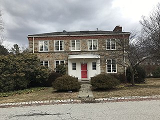
Middle East is a neighborhood in the heart of East Baltimore, Maryland.
Route 20 is a bus route operated by the Maryland Transit Administration in Baltimore and its suburbs. The line currently runs from Security Square Mall east through downtown Baltimore to Baltimore City Hall. The main roads on which the line operates are Old Frederick Road, Baltimore Street, Fayette Street, and Boston Street. The line serves the communities of Westview, Edmondson Village.

Johnston Square is a neighborhood in central Baltimore, Maryland located east of the Fallsway and west of the Oliver neighborhood, bordered by Greenmount Cemetery at the north and Eager Street at the south.
St. Paul Street and Calvert Street are a one-way pair of streets in Downtown Baltimore and areas north. The streets, which are part of Maryland Route 2, are two of Baltimore's best-known streets in the downtown area.
Mondawmin Mall is a three-level shopping mall in West Baltimore, Maryland, United States. The mall was a development of the Mondawmin Corporation, a firm set up in 1952 by James Rouse and Hunter Moss under the Moss-Rouse Company. When it first opened in October 1956, it had an open-air plan and was called the Mondawmin Center. It was later enclosed and renamed the Mondawmin Mall.

Shot Tower station is an underground Metro SubwayLink station in Baltimore, Maryland. It is in the central part of the city, in close proximity to many well-known landmarks, including the Shot Tower for which it is named, Port Discovery, Power Plant Live!, the Harbor campus of Baltimore City Community College, the National Aquarium, the Flag House, and Little Italy. The station has two street-level entrances, but unlike other Baltimore Metro stations that do, both these entrances share a common gate inside the station. The Shot Tower station is one of two stops in the third phase of the Baltimore Metro, having opened in 1995. Originally named Shot Tower/Market Place to showcase the proximity to the Market Place development, MTA Maryland dropped Market Place from its title with the 2017 rebranding of BaltimoreLink.

Jonestown is a neighborhood in the southeastern district of Baltimore. Its boundaries are the north side of Pratt Street, the west side of Central Avenue, the east side of Fallsway, and the south side of Orleans Street. The neighborhood lies north of the Little Italy, south of the Old Town, west of the Washington Hill, and east of the Downtown Baltimore neighborhoods. The southern terminus of the Jones Falls Expressway is located here.

Medfield is a neighborhood located in north Baltimore, Maryland, United States of America. It is located to the north of the trendy Hampden neighborhood and south of affluent Roland Park neighborhood. Its unofficial boundaries are Coldspring Lane to the north; Jones Falls Expressway to the west; Falls Road/Hickory Avenue to the east; and West 41st Street to the south.

The Jones Falls is a 17.9-mile-long (28.8 km) stream in Maryland. It is impounded to create Lake Roland before running through the city of Baltimore and finally emptying into the Baltimore Inner Harbor.
The Baltimore City Heritage Walk is a heritage trail that links 20 historic sites and museums in downtown Baltimore, Maryland.
The Orchards is a neighborhood in the North District of Baltimore, located between the neighborhoods of New North Roland Park–Poplar Hill and Bellona–Gittings. Its boundaries are marked by the Baltimore County line (north), Maryland Route 133 Northern Parkway (south), and Maryland Route 139 Charles Street (east). Roland Avenue, West Lake Avenue, Kenmore Road and Melrose Avenue draw the neighborhood's west boundary.

Gywnns Falls Trail is a 15-mile (24 km) series of hiking and bicycling trails inside Baltimore, Maryland, named for the Gwynns Falls, whose course it follows, and the surrounding Gwynns Falls Leakin Park it passes through. The trail uses unique alignments, sidepaths on existing streets, and on-street sections. The trail consists of one 10.75-mile (17.30 km) mainline, plus a number of branches, including the Middle Branch Trail, the Hutton Trail, and the Dickeyville Trail. All of these trails carry signage designating them as the Gwynns Falls Trail; their individual names are designated on the mile markers designating their route. The entirety of the Middle Branch Trail, as well as the section of the mainline trail east of the Middle Branch Trail's northern terminus, are part of the East Coast Greenway.
A United States postage stamp and the names of a number of recreational and cultural facilities, schools, streets and other facilities and institutions throughout the United States have commemorated Benjamin Banneker's documented and mythical accomplishments throughout the years since he lived (1731–1806). Among such memorializations of this free African American almanac author, surveyor, landowner and farmer who had knowledge of mathematics, astronomy and natural history was a biographical verse that Rita Dove, a future Poet Laureate of the United States, wrote in 1983 while on the faculty of Arizona State University.
