Charles Street (Baltimore)

Last updated

MD Route 139.svg

Maryland Route 139

Charles Street
Maryland Route 139 map.png
Route information
Maintained by MDSHA and Baltimore DOT
Length10.9 mi [1]  (17.5 km)
MD 139 is 7.89 mi (12.70 km). [2] [3]
The unnumbered portion of Charles Street south of US 1 is 3.0 mi (4.8 km). [1]
Existed1927–present
Tourist
routes
MUTCD D6-4.svg Baltimore's Historic Charles Street
Major junctions
South endDead end near Wells Street in Baltimore
Major intersections
North endNightlingale Way in Lutherville
Location
Country United States
State Maryland
Counties City of Baltimore, Baltimore
Highway system
MD Route 138.svg MD 138 MD Route 140.svg MD 140

Charles Street, known for most of its route as Maryland Route 139 (MD 139), runs through Baltimore and the Towson area of Baltimore County. On the north end, it terminates at an intersection with Bellona Avenue near Interstate 695 (I-695). At the south end, it terminates in Federal Hill in Baltimore. Charles Street is one of the major routes through Baltimore, and is a major public transportation corridor. For the one-way portions of Charles Street, the street is functionally complemented by the parallel St. Paul Street, including St. Paul Place and Preston Gardens, Maryland Avenue, Cathedral Street, and Liberty Street.

Contents

Though not exactly at the westeast midpoint of the city, Charles Street is the dividing line between the west and east sides of Baltimore. On any street that crosses Charles Street, address numbers start from the unit block on either side, and the streets are identified as either "West" or "East," depending on whether they are to the west or east of Charles. [4]

The west and east designations also apply to streets that do not cross Charles Street, but exist on both sides of it. The entire length of Charles Street is a National Scenic Byway known as Baltimore's Historic Charles Street. [5] [6]

Route description

MD 139 begins at US 1/US 40 Truck in Baltimore (better known as North Avenue). MD 139 follows Charles Street northbound; the southbound lanes of MD 139 are carried by Saint Paul Street. Charles Street is a part of the National Highway System from Pratt Street to its northern terminus in Lutherville, which includes the entire length of MD 139. [3] [7]

South Baltimore to North Avenue

Charles Street begins at a dead end one block south of Wells Street in the South Baltimore neighborhood of Baltimore. The terminus is immediately to the north of CSX's Locust Point Branch of the Baltimore Terminal Subdivision railroad line and I-95 and two blocks to the west of the historic National Enameling and Stamping Company factory complex. Charles Street heads north as a two-lane undivided street through residential South Baltimore. The street becomes commercial as it passes between the Federal Hill and Sharp Leadenhall neighborhoods. Federal Hill contains the Holy Cross Roman Catholic Church on West Street and the Cross Street Market on the eponymous street. Sharp Leadenhall contains the Little Montgomery Street Historic District. At the north end of the two neighborhoods, Charles Street intersects MD 2, which follows Montgomery Street east and Hughes Street west on its two-block transfer from Hanover Street, which the route follows south toward the Hanover Street Bridge over the Patapsco River, to Light Street at the southwest corner of the Inner Harbor. Charles Street enters the Otterbein neighborhood, where it becomes one-way northbound at Lee Street. At the northern end of the neighborhood, Charles Street intersects Conway Street, a four-block boulevard that passes the Otterbein Church and connects Light Street at the Inner Harbor with I-395 and Howard Street just east of the Baltimore & Ohio Warehouse at Camden Yards and Oriole Park at Camden Yards, home to Major League Baseball's Baltimore Orioles. [1]

Charles Street looking south from Chase Street in Baltimore CharlesandChase.jpg
Charles Street looking south from Chase Street in Baltimore

Charles Street continues north as a three-lane street through the Inner Harbor neighborhood on the south side of downtown Baltimore. The street passes to the east of the Baltimore Convention Center and intersects the two main streets of the Inner Harbor area, eastbound Pratt Street and westbound Lombard Street, between which is the Transamerica Tower (formerly the Legg Mason Building). Charles Street passes to the west of the M&T Bank Building and Bank of America Building before reaching the center of the city's address system at Baltimore Street. The street passes to the east of Charles Center and the Charles Center station of MTA Maryland's Baltimore Metro SubwayLink. Charles Street continues north into the Cathedral Hill Historic District, where the street passes St. Paul's Episcopal Church at Saratoga Street, the Woman's Industrial Exchange and Brown's Arcade at Pleasant Street, the Baltimore Basilica at Mulberry Street, and the Benson Building and First Unitarian Church of Baltimore at Franklin Street. Mulberry and Franklin streets carry US 40 eastbound and westbound, respectively. [1]

Charles Street enters the Mount Vernon neighborhood at Centre Street, which contains the Walters Art Museum and Contemporary Museum Baltimore to the west. The street splits into a pair of two-lane roadways separated by park squares known as Washington Place. South of the eastwest portion of the park, Charles Street passes the equestrian Lafayette Monument within the park and the Peabody Institute on the east and the Walters Art Museum on the west. The street meets the westbound and eastbound halves of Mount Vernon Place, (also East and West Monument Street) which flank the eastwest segment of the part, at a traffic circle that surrounds the Washington Monument. The eastern leg of the park contains the George Peabody Sculpture and one of Severn Teackle Wallis facing St. Paul Street to the east. The bifurcated Charles Street continues past the Roger B. Taney Sculpture in the northern square of the park, Mount Vernon Place United Methodist Church and Asbury House to the east, and The Stafford Apartments to the west and the equestrian statue of Col. John Eager Howard facing north towards Madison Street. The two halves of Charles Street converge as a three-lane street at Madison Street. [1]

University Baptist Church across from Johns Hopkins University UniversityBaptistChurchBaltimore.jpg
University Baptist Church across from Johns Hopkins University

Charles Street continues through midtown Baltimore, which contains the Belvedere Hotel and several historic rowhouses on adjacent Chase Street. The street passes along the east side of the University of Baltimore and University of Baltimore School of Law before meeting I-83 (Jones Falls Expressway) at the northern end of the neighborhood. The partial interchange with I-83 features ramps from southbound I-83 to Maryland Avenue one block to the west and to Charles Street itself, and an entrance ramp from Charles Street to northbound I-83. Immediately to the east of the I-83 overpass is Pennsylvania Station, the main train station of Baltimore that has intercity service on Amtrak, commuter service on MARC's Penn Line, and light rail service on the Penn Station spur of MTA Maryland's Baltimore Light RailLink. Charles Street crosses over several tracks of Amtrak's Northeast Corridor railroad line and enters the Charles North neighborhood. Between Lanvale and Lafayette streets, which form the east and west components of MD 25 (which becomes Falls Road), the street passes the Charles Theatre and the Baltimore City Passenger Railway Power House and Car Barn. Charles Street continues one more block as an unnumbered highway before reaching the southern terminus of MD 139 at North Avenue, which carries US 1 and US 40 Truck. [1]

North Avenue to Lutherville

Charles Street continues as northbound MD 139 through the Charles North neighborhood, where the street passes the Old Goucher College Buildings. The street is paralleled by Maryland Avenue to the west and St. Paul Street to the east, the latter being southbound MD 139. Charles Street continues into Charles Village. At 29th Street, Maryland Avenue merges into Charles Street, which becomes a divided boulevard that contains three lanes northbound and one lane southbound. St. Paul Street, which serves as the main commercial street of the neighborhood, becomes two lanes southbound and one lane northbound at 31st Street and passes Union Memorial Hospital. The boulevard passes between the main part of Charles Village and auxiliary Johns Hopkins University buildings to the east and the Baltimore Museum of Art and the Homewood Campus of Johns Hopkins University, and the campus's Homewood Museum to the west. North of 33rd Street, Charles and St. Paul streets enter the Homewood neighborhood, where they each have oblique intersections with University Parkway, which leads northwest to the First Church of Christ, Scientist and the Lacrosse Museum and National Hall of Fame at the northern end of the Hopkins campus. [1] [2]

A sign for Johns Hopkins University JHU Homewood sign.jpg
A sign for Johns Hopkins University

Charles Street and St. Paul Street continue north as two-way, four-lane streets through the well wooded residential neighborhoods of Tuscany-Canterbury to the west of Charles Street and Guilford to the east. North of the Highfield House Condominium, Charles Street splits, with southbound traffic using Charles Street proper, which passes the Calvert School, and northbound traffic continuing straight on Charlcote Road, which intersects St. Paul Street, which had curved to the east and veered back northwest within the Guilford neighborhood. Both directions of MD 139 follow St. Paul Street to its northern end at Charles Street and Overhill Road. Two blocks north of the junction, four-lane undivided Charles Street intersects Cold Spring Lane. The street continues through the campus of Loyola University Maryland; the two sides of the campus are connected by a pedestrian bridge. Charles Street passes the Evergreen Museum & Library before passing between the Blytheville neighborhood to the west and Notre Dame of Maryland University (formerly College of Notre Dame of Maryland, or CONDOM). Charles Street continues north between Homeland and Wyndhurst, the latter the home of the Friends School of Baltimore and the Cathedral of Mary Our Queen. The street intersects Northern Parkway and Lake Avenue, which leads to the Boys' Latin School of Maryland, and passes between two more neighborhoods, The Orchards to the west and Bellona-Gittings to the east, before leaving Baltimore and entering Baltimore County. [1] [2]

MD 139 north of MD 134 in Towson 2020-07-30 11 35 44 View north along Maryland State Route 139 (Charles Street) at Maryland State Route 134 (Bellona Avenue) in Towson, Baltimore County, Maryland.jpg
MD 139 north of MD 134 in Towson

North of Elkridge Hunt Club, whose golf course lies to the west, Charles Street passes through the hamlet of Woodbrook, within which lies the historic home Tyrconnell on Lake Roland to the west. At Bellona Avenue, which heads northwest as MD 134, Charles Street becomes a four-lane divided highway that passes through an S-curve within a forested area. The highway passes to the west of Greater Baltimore Medical Center and The Sheppard and Enoch Pratt Hospital, then intersects Towsontown Boulevard, which leads to the old alignment of Charles Street, Charles Street Avenue, and both Towson University and the center of Towson. Charles Street veers northwest past the Loyola Blakefield school and north again to the top of a ridge where the highway passes under Joppa Road. That road is accessed at the following intersection with Bellona Road, which heads west and then south toward Riderwood and Ruxton, and Kenilworth Drive, which heads east toward the center of Towson. Charles Street has a partial cloverleaf interchange with I-695 (Baltimore Beltway) before meeting a disjoint segment of Bellona Avenue at an intersection with traffic lights (for the better part of a decade traffic was managed by a roundabout) on the southern edge of Lutherville. [8] Bellona Avenue heads west toward a ramp to westbound I-695 and east to receive an exit ramp from westbound I-695 and intersect MD 131 (Seminary Avenue) within the Lutherville Historic District. Although MD 139 ends at the intersection, Charles Street continues north one block as a residential street to its northern terminus, where the road heads west into an apartment complex as Nightingale Way. [1] [3]

History

MD 139 northbound viewed from West Joppa Road in Towson 2020-07-30 10 25 30 View north along Maryland State Route 139 (Charles Street) from the overpass for West Joppa Road in Towson, Baltimore County, Maryland.jpg
MD 139 northbound viewed from West Joppa Road in Towson

When Charles Street was first laid out in the Town of Baltimore in 1730, it was originally known as Forest (or Forrest) Street. [9] [10] The southern end was at the present day Lombard Street at what was called Uhler's Spring Branch. [11] The road was being referred to as Charles Street by at least 1761. [10] In 1858, the Jones Falls flooded and overflowed. The bridge along Charles Street (near present-day Penn Station) was swept away. [11]

The first portion of what was known as Charles Street Avenue to be paved in Baltimore County was west of the center of Towson, from Chesapeake Avenue north to Joppa Road, by 1915. [12] [13] The remainder of the highway in Baltimore County was paved in 1928 and marked as MD 139 by 1933. [14] By 1934, traffic levels were high enough on the highway that the Maryland State Roads Commission recommended widening the road in Baltimore County from 14 to 20 feet (4.3 to 6.1 m) to 30 feet (9.1 m) in width. [15] Within Baltimore, MD 139 was split into a one-way pair between North Avenue and 29th Street, with northbound following Charles Street and southbound using Maryland Avenue, by 1950. [16]

In 1954, a project began to widen MD 139 from the Baltimore city line north to MD 134. [17] In addition, preliminary work began at the site of the highway's future interchange with I-695 that year and actual construction began in 1955. [17] [18] Starting in 1956, MD 139 was expanded to a four-lane divided highway from MD 134 to the modern intersection with Towsontown Boulevard and relocated as a four-lane divided highway from there to the Beltway interchange. [19] Construction was completed from the Beltway interchange south to Joppa Road and from MD 134 to Towsontown Boulevard in 1957. [20] The relocation project, including Joppa Road's bridge over MD 139, was completed in 1958. [19] [21] [22] The bypass was marked as MD 139 by 1959 and the old segment of Charles Street Avenue was transferred to county maintenance by 1961. [23] [24] In 1963, the southbound direction of the state highway was assigned to St. Paul Street from North Avenue to the street's northern end at Charles Street; the street was a two-way divided boulevard north of 33rd Street. [25]

The intersection with Bellona Avenue at the state highway's northern terminus in Lutherville was replaced with a roundabout in 1999. [26] [27] This roundabout was later removed and replaced with a standard intersection as part of reconstruction of MD 139 and I-695 around their interchange that started in 2008. [28]

Junction list

This table only includes details for the portion of Charles Street designated MD 139.

CountyLocationmi
[2] [3]
kmDestinationsNotes
Baltimore City Charles Street continues south as an unnumbered city street through Downtown Baltimore for 3.0 miles (4.8 km) toward the street's southern terminus at a dead end near Wells Street. [1]
0.000.00US 1.svgTruck plate.svg
US 40.svg
US 1  / US 40 Truck (North Avenue)
Southern terminus
1.502.41University Parkway
2.483.99 Cold Spring Lane
3.625.83 Northern Parkway
Baltimore Towson 5.048.11North plate.svg
MD Route 134.svg
MD 134 north (Bellona Avenue) / Bellona Avenue south
Southern terminus of MD 134
Lutherville 7.8012.55I-695.svgTo plate blue.svg
I-83.svg
I-695 (Baltimore Beltway) to I-83  York, PA, Pikesville, Baltimore, Essex
I-695 Exit 25
7.8912.70Bellona Avenue / Charles Street northNorthern terminus; intersection; Bellona Avenue is unsigned MD 139A (east)
1.000 mi = 1.609 km; 1.000 km = 0.621 mi

Auxiliary routes

MD 139 has one current and one former auxiliary route in Lutherville. Both routes were designated in 2004 as notational upgrades to what were previously classified as ramps. [29]

See also

Related Research Articles

<span class="mw-page-title-main">Interstate 97</span> Short Interstate Highway in Maryland

Interstate 97 (I-97) is a north-south Interstate Highway in the eastern United States. It runs entirely within Anne Arundel County, Maryland, for 17.62 miles (28.36 km) from U.S. Route 50/U.S. Route 301 (US 50/US 301) in Parole near Annapolis north to I-695 and I-895 in Brooklyn Park near Baltimore. The interstate is the primary highway between Baltimore and Annapolis. I‑97 connects Annapolis with Baltimore/Washington International Airport and links the northern Anne Arundel County communities of Crownsville, Millersville, Severna Park, Glen Burnie, and Ferndale. It is the second shortest primary Interstate Highway after I-87 in North Carolina.

<span class="mw-page-title-main">Baltimore–Washington Parkway</span> Highway in Maryland, United States

The Baltimore–Washington Parkway is a controlled-access parkway in the U.S. state of Maryland, running southwest from Baltimore to Washington, D.C. The road begins at an interchange with U.S. Route 50 (US 50) near Cheverly in Prince George's County at the Washington, D.C. border, and continues northeast as a parkway maintained by the National Park Service (NPS) to MD 175 near Fort Meade, serving many federal institutions. This portion of the parkway is dedicated to Gladys Noon Spellman, a representative of Maryland's 5th congressional district, and has the unsigned Maryland Route 295 (MD 295) designation. Commercial vehicles, including trucks, are prohibited within this stretch. This section is administered by the NPS's Greenbelt Park unit. After leaving park service boundaries the highway is maintained by the state and signed with the MD 295 designation. This section of the parkway passes near Baltimore–Washington International Thurgood Marshall Airport.

<span class="mw-page-title-main">Interstate 895</span> Highway in Maryland

Interstate 895 (I-895) is an auxiliary Interstate Highway in the US state of Maryland. Known as the Harbor Tunnel Thruway, the highway runs 11.44 miles (18.41 km) between one junction with I-95 in Elkridge and another interchange with I-95 on the east side of Baltimore. I-895 is a toll road that crosses the Patapsco River estuary via the Baltimore Harbor Tunnel, connecting U.S. Route 1 (US 1), I-695, and the Baltimore–Washington Parkway in the southwestern suburbs of Baltimore with US 40 on the east side of Baltimore. In conjunction with a pair of spurs, unsigned I-895A and I-895B, I-895 provides access to the tunnel from I-97 and Maryland Route 2 (MD 2) in Glen Burnie. The highway is designed for through traffic by having partial interchanges that require vehicles from almost all starting points to pass through the tunnel and the tunnel toll plaza, where a $1.40-$6.00 toll is charged to passenger vehicles, before exiting the facility.

<span class="mw-page-title-main">Interstate 695 (Maryland)</span> Highway in Maryland

Interstate 695 (I-695) is a 51.46-mile-long (82.82 km) auxiliary Interstate Highway that constitutes a beltway extending around Baltimore, Maryland, United States. I-695 is officially designated the McKeldin Beltway but is colloquially referred to as either the Baltimore Beltway or 695. The route is an auxiliary route of I-95, intersecting that route southwest of Baltimore near Arbutus and northeast of the city near White Marsh. It also intersects other major roads radiating from the Baltimore area, including I-97 near Glen Burnie, the Baltimore–Washington Parkway near Linthicum, I-70 near Woodlawn, I-795 near Pikesville, and I-83 in the Timonium area. The 19.37-mile (31.17 km) portion of the Baltimore Beltway between I-95 northeast of Baltimore and I-97 south of Baltimore is officially Maryland Route 695 (MD 695) and is not part of the Interstate Highway System but is signed as I-695. The Francis Scott Key Bridge that crossed over the Patapsco River was included in this section of the route before the bridge's collapse on March 26, 2024. The bridge and its approaches were maintained by the Maryland Transportation Authority (MDTA), while the remainder of the Baltimore Beltway is maintained by the Maryland State Highway Administration (MDSHA).

<span class="mw-page-title-main">Interstate 395 (Maryland)</span> Short Interstate Highway in Baltimore, Maryland

Interstate 395 (I-395) is an auxiliary Interstate Highway in the US state of Maryland. Known as Cal Ripken Way, the highway runs 1.98 miles (3.19 km) from I-95 north to Howard Street and Camden Street in Downtown Baltimore, where it provides access to the Inner Harbor and the Baltimore Convention Center. The Interstate also serves the Camden Yards Sports Complex, which contains M&T Bank Stadium and Oriole Park at Camden Yards, homes of the Baltimore Ravens and Baltimore Orioles, respectively. I-395 also serves as the southern terminus of Martin Luther King Jr. Boulevard, an urban arterial that provides a western bypass of Downtown Baltimore and connects I-95 with U.S. Route 40 (US 40), US 1, and I-83. The Interstate is maintained by the Maryland Transportation Authority (MDTA) and, like all Interstates, is a part of the National Highway System.

<span class="mw-page-title-main">Maryland Route 2</span> State highway in Maryland, US

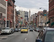
Maryland Route 2 is the longest state highway in the U.S. state of Maryland. The 79.24-mile (127.52 km) route runs from Solomons Island in Calvert County north to an intersection with U.S. Route 1 /US 40 Truck in Baltimore. The route runs concurrent with MD 4 through much of Calvert County along a four-lane divided highway known as Solomons Island Road, passing through rural areas as well as the communities of Lusby, Port Republic, Prince Frederick, and Huntingtown. In Sunderland, MD 2 splits from MD 4 and continues north as two-lane undivided Solomons Island Road into Anne Arundel County, still passing through rural areas. Upon reaching Annapolis, the route runs concurrent with US 50/US 301 to the north of the city. Between Annapolis and Baltimore, MD 2 runs along the Governor Ritchie Highway, a multilane divided highway that heads through suburban areas, passing through Arnold, Severna Park, Pasadena, Glen Burnie, and Brooklyn Park. In Baltimore, the route heads north on city streets and passes through the downtown area of the city.

<span class="mw-page-title-main">Maryland Route 648</span> Highway in Maryland

Maryland Route 648 is a collection of state highways in the U.S. state of Maryland. These nine highways are current or former sections of the Baltimore–Annapolis Boulevard between Annapolis and Baltimore via Glen Burnie. There are five signed mainline segments of MD 648 through Arnold, Severna Park, Pasadena, Glen Burnie, Ferndale, and Pumphrey in northern Anne Arundel County; Baltimore Highlands in southern Baltimore County; and the independent city of Baltimore. MD 648 mainly serves local traffic along its meandering route, with long-distance traffic intended to use the parallel and straighter MD 2 south of Glen Burnie and freeway-grade Interstate 97 (I-97), I-695, and MD 295 between Glen Burnie and Baltimore.

<span class="mw-page-title-main">Maryland Route 147</span> State highway in Maryland, known as Harford Road

Maryland Route 147 is a state highway in the U.S. state of Maryland. Known as Harford Road, the state highway runs 18.82 miles (30.29 km) from U.S. Route 1 and US 40 Truck in Baltimore north to US 1 and US 1 Business in Benson. MD 147 is an alternate route to US 1 between Baltimore and Bel Air, the county seat of Harford County. The state highway is the main street of several neighborhoods in Northeast Baltimore and the Baltimore County suburbs of Parkville and Carney. MD 147 is maintained by the Maryland State Highway Administration in Baltimore and Harford counties and by the Baltimore City Department of Transportation within the city. Harford Road was a pair of turnpikes before the Baltimore–Carney portion of the highway was designated one of the original state roads. The Baltimore County section of MD 147 was constructed in the early 1910s and widened multiple times in the late 1920s and 1930s. The section of the state highway in Harford County was built in the late 1920s.

<span class="mw-page-title-main">Maryland Route 144</span> State highway in Maryland, US

Maryland Route 144 is a collection of state highways in the U.S. state of Maryland. These highways are sections of old alignment of U.S. Route 40 between Cumberland and Baltimore. Along with US 40 Scenic, US 40 Alternate, and a few sections of county-maintained highway, MD 144 is assigned to what was once the main highway between the two cities, connecting those endpoints with Hancock, Hagerstown, Frederick, New Market, Mount Airy, Ellicott City, and Catonsville. MD 144 has seven disjoint sections of mainline highway that pass through the Appalachian Mountains in Allegany and Washington counties and the rolling Piedmont of Frederick, Carroll, Howard, and Baltimore counties.

<span class="mw-page-title-main">Maryland Route 150</span> State highway in, Maryland, US, known as Eastern Ave or Eastern Blvd

Maryland Route 150 (MD 150) is a state highway in the U.S. state of Maryland. Known for most of its length as either Eastern Avenue or Eastern Boulevard, the highway runs 13.01 miles (20.94 km) from U.S. Route 40 (US 40) in Baltimore east to Graces Quarters Road in Chase in eastern Baltimore County. MD 150 connects Baltimore with its southeastern suburbs of Dundalk, Essex, and Middle River. The state highway also links those communities with Interstate 95 (I-95), I-695, I-895, and Martin State Airport. MD 150 was constructed from Baltimore to Middle River and in Chase in the mid-1920s. The road was completed through Middle River in the early 1930s. Between 1942 and 1944, MD 150 was reconstructed as a four-lane divided highway with interchanges to improve access between Baltimore and the Glenn L. Martin Company aircraft manufacturing plant in Middle River. The highway has followed several routes since it was extended west into the city of Baltimore in the mid-1940s; the present route in East Baltimore was established shortly after 2000.

<span class="mw-page-title-main">Maryland Route 151</span> State highway in Maryland, US, known as North Point Blvd

Maryland Route 151 (MD 151) is a state highway in the U.S. state of Maryland. Known for most of its length as North Point Boulevard, the state highway runs 10.80 miles (17.38 km) from 7th Street in Sparrows Point north to U.S. Route 1 (US 1) in Baltimore. MD 151 is a four- to six-lane divided highway that connects the communities of Edgemere and Dundalk on the Patapsco River Neck peninsula of southeastern Baltimore County with industrial areas in Sparrows Point and East Baltimore. MD 151 was originally constructed in the early 1920s from Sparrows Point to Edgemere. The highway was connected to Baltimore by the Baltimore County portion of MD 20, a number also assigned to the highway from Rock Hall to Chestertown in Kent County. During World War II, MD 151 was extended north through Dundalk on a new divided highway parallel to MD 20 and through East Baltimore on an expanded Erdman Avenue to connect the Bethlehem Steel complex at Sparrows Point with MD 150 and US 40. In the late 1960s and early 1970s, Interstate 695 (I-695) was constructed parallel to MD 151 between Edgemere and MD 157 in Dundalk.

<span class="mw-page-title-main">Maryland Route 158</span> State highway in Baltimore County, Maryland, known as Bethlehem Blvd

Maryland Route 158 is a state highway located in Baltimore County in the U.S. state of Maryland. Known as Bethlehem Boulevard, the state highway runs 2.35 miles (3.78 km) from Riverside Drive in Sparrows Point east to North Point Road in Edgemere. MD 158 parallels Interstate 695 (I-695) along the northern edge of the former Bethlehem Steel complex at Sparrows Point and connects MD 157 with MD 151. Bethlehem Boulevard was constructed as a four-lane divided county highway with several interchanges in the late 1950s. The highway was designated MD 158 in the early 1990s. When I-695 was completely rebuilt and expanded from two to four lanes through Sparrows Point and Edgemere in the late 1990s, MD 158 was also reconstructed as a mostly two-lane highway without interchanges.

<span class="mw-page-title-main">Maryland Route 173</span> State highway in Maryland

Maryland Route 173 is a state highway in the U.S. state of Maryland. Known for most of its length as Fort Smallwood Road, the state highway runs 13.78 miles (22.18 km) from Fort Smallwood Park near Jacobsville north to MD 2 in the Brooklyn neighborhood of Baltimore. MD 173 connects the beach communities of Riviera Beach and Orchard Beach in northeastern Anne Arundel County and Interstate 695 (I-695) with industrial areas in the Baltimore neighborhoods of Hawkins Point and Curtis Bay, including the United States Coast Guard Yard. MD 173 was mostly constructed in the 1920s and early 1930s. The state highway was put in its modern form with the completion of the bridge over Stony Creek in the late 1940s and expansion to a divided highway between Orchard Beach and Curtis Bay in the late 1970s.

<span class="mw-page-title-main">Maryland Route 140</span> State highway in Maryland, US

Maryland Route 140 is a 49-mile (79 km) state highway in the U.S. state of Maryland. The route runs from U.S. Route 1 and US 40 Truck in Baltimore northwest to the Pennsylvania border, where the road continues into that state as Pennsylvania Route 16. MD 140 passes through the northern part of central Maryland, connecting Baltimore, Pikesville, Reisterstown, Westminster, Taneytown, and Emmitsburg.

<span class="mw-page-title-main">Interstate 70 in Maryland</span> Section of Interstate Highway in Maryland

Interstate 70 (I-70) is a part of the Interstate Highway System that runs from Cove Fort, Utah, to Woodlawn just outside of Baltimore, Maryland. In Maryland, the Interstate Highway runs 91.85 miles (147.82 km) from the Pennsylvania state line in Hancock east to the Interstate's eastern terminus at its junction with I-695. I-70 is the primary east–west Interstate in Maryland; the Interstate Highway connects Baltimore—and Washington, D.C., via I-270—with Western Maryland. The Interstate serves Frederick and Hagerstown directly and provides access to Cumberland via its junction with I-68 at Hancock. I-70 runs concurrently with its predecessor highway, U.S. Route 40 (US 40), from Hancock to Indian Springs in Washington County and from Frederick to West Friendship in Howard County.

<span class="mw-page-title-main">Maryland Route 134</span> State highway in Baltimore County, Maryland, known as Bellona Ave

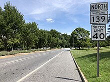
Maryland Route 134 is a signed state highway in the U.S. state of Maryland. Known as Bellona Avenue, the state highway runs 1.63 miles (2.62 km) from MD 139 in Towson north to Ruxton Road in Ruxton in central Baltimore County. MD 134 was created as a modern road from MD 139 northwest to MD 25 in 1928. The highway was reduced to its present length in 1962.

<span class="mw-page-title-main">Maryland Route 129</span> State highway in Maryland, US

Maryland Route 129 is a state highway in the U.S. state of Maryland, running north-northwesterly from U.S. Route 40 and MD 295 in the city of Baltimore into Baltimore County, ending at Garrison Forest Road east of Reisterstown. The route leaves downtown on the one-way pair of McCulloh Street and Druid Hill Avenue, and then uses the entire length of Park Heights Avenue to the end. MD 129 connects Downtown Baltimore with Druid Hill Park using McCulloh Street and Druid Hill Avenue. As Park Heights Avenue, the state highway is one of two primary radial routes in the northwestern part of the city, providing access to The Maryland Zoo and Pimlico Race Course. In Baltimore County, MD 129 passes through Pikesville, where it has a junction with Interstate 695 (I-695) and serves an affluent rural area north of Pikesville and east of Reisterstown.

<span class="mw-page-title-main">Maryland Route 25</span> State highway in Maryland, US

Maryland Route 25, locally known for nearly its entire length as Falls Road, is a state highway in the U.S. state of Maryland. It begins north of downtown Baltimore, just north of Penn Station, and continues north through Baltimore County to Beckleysville Road near the Pennsylvania state line. The road passes through the communities of Hampden, Medfield, Cross Keys, and Mount Washington in the city, and Brooklandville and Butler in Baltimore County. The entire length of MD 25 that uses Falls Road—and its county-maintained continuation north to Alesia—is a Maryland Scenic Byway, named the Falls Road Scenic Byway.

Joppa Road is a county highway in the U.S. state of Maryland. The highway extends 14.3 miles (23.0 km) from Maryland Route 25 in Brooklandville east to MD 7 near White Marsh. Joppa Road has three main segments separated by very short breaks on its course through central and eastern Baltimore County. The central segment is a multi-lane highway from MD 45 and MD 146 in the county seat of Towson to U.S. Route 1 in Perry Hall. This highway is mostly a commercial strip and parallels Interstate 695 (I-695) through Towson, Parkville, and Carney. The western and eastern segments of Joppa Road are two-lane roads through mainly residential areas. The western segment connects Brooklandville and Towson via Riderwood. The eastern segment serves parts of Perry Hall and White Marsh.

<span class="mw-page-title-main">Maryland Route 542</span> State highway in Maryland, United States

Maryland Route 542 is a state highway in the U.S. state of Maryland. Known for most of its length as Loch Raven Boulevard, the state highway runs 6.33 miles (10.19 km) from MD 147 in Baltimore north to Interstate 695 (I-695) and Cromwell Bridge Road near Towson. MD 542 is a four-lane divided highway that connects portions of Northeast Baltimore with Towson and I-695. The state highway is maintained by the Maryland State Highway Administration in Baltimore County and the Baltimore City Department of Transportation in the city. MD 542 was constructed in the early to mid-1930s. The highway was expanded to a divided highway in Baltimore by 1950 and in Baltimore County in the mid- to late 1950s.

References

  1. 1 2 3 4 5 6 7 8 9 10 Google (2012-02-07). "Charles Street" (Map). Google Maps . Google. Retrieved 2012-02-07.
  2. 1 2 3 4 Highway Information Services Division (December 31, 2005). Highway Location Reference. Maryland State Highway Administration. Retrieved 2012-02-03.
  3. 1 2 3 4 5 Highway Information Services Division (December 31, 2013). Highway Location Reference. Maryland State Highway Administration. Retrieved 2012-02-03.
  4. Tilghman, Mary K. (2008-01-01). Insiders' Guide to Baltimore. Globe Pequot. ISBN   9780762745531.[ permanent dead link ]
  5. "Maryland Byways" (PDF). Maryland State Highway Administration. Retrieved 2011-01-24.
  6. "Baltimore's Historic Charles Street". National Scenic Byways Program. Archived from the original on 2009-11-19. Retrieved 2012-03-28.
  7. National Highway System: Baltimore, MD (PDF) (Map). Federal Highway Administration. October 1, 2012. Retrieved 2015-05-16.
  8. Marney Kirk, New Traffic Lights at Charles Street Circle, December 14, 2010.
  9. Scharf, John Thomas (1881). History of Baltimore City and County, from the Earliest Period to the Present Day: Including Biographical Sketches of Their Representative Men. L.H. Everts. p.  53. charles streetbaltimore.
  10. 1 2 "Historic Charles Street Association". Archived from the original on 2010-08-20. Retrieved 2010-06-27.
  11. 1 2 Scharf, John Thomas (1881-01-01). History of Baltimore City and County, from the Earliest Period to the Present Day: Including Biographical Sketches of Their Representative Men. L.H. Everts.
  12. "Report of the State Roads Commission of Maryland" (1912–1915 ed.). Baltimore: Maryland State Roads Commission. May 1916: 122 . Retrieved 2012-02-06.{{cite journal}}: Cite journal requires |journal= (help)
  13. Map of Maryland: Showing State Road System and State Aid Roads (Map) (1921 ed.). Maryland Geological Survey.
  14. Map of Maryland: Showing State Road System and State Aid Roads (Map) (1928 ed.). Maryland Geological Survey.
  15. "Report of the State Roads Commission of Maryland" (1931–1934 ed.). Baltimore: Maryland State Roads Commission. 1934-12-28: 20 . Retrieved 2012-02-06.{{cite journal}}: Cite journal requires |journal= (help)
  16. Maryland: Official Highway Map (Map) (1950 ed.). Maryland State Roads Commission.
  17. 1 2 "Report of the State Roads Commission of Maryland" (1953–1954 ed.). Baltimore: Maryland State Roads Commission. 1954-11-12: 177, 179. Retrieved 2012-02-06.{{cite journal}}: Cite journal requires |journal= (help)
  18. "Report of the State Roads Commission of Maryland" (1955–1956 ed.). Baltimore: Maryland State Roads Commission. 1956-11-02: 161, 164. Retrieved 2012-02-06.{{cite journal}}: Cite journal requires |journal= (help)
  19. 1 2 "Report of the State Roads Commission of Maryland" (1957–1958 ed.). Baltimore: Maryland State Roads Commission. 1958-12-15: 62 . Retrieved 2012-02-06.{{cite journal}}: Cite journal requires |journal= (help)
  20. Maryland: Official Highway Map (Map) (1957 ed.). Maryland State Roads Commission.
  21. Maryland: Official Highway Map (Map) (1958 ed.). Maryland State Roads Commission.
  22. "NBI Structure Number: 100000030079010". National Bridge Inventory. Federal Highway Administration. Archived from the original on 2015-12-12. Retrieved 2012-02-06.
  23. Maryland: Official Highway Map (Map) (1959 ed.). Maryland State Roads Commission.
  24. Maryland: Official Highway Map (Map) (1961 ed.). Maryland State Roads Commission.
  25. Maryland: Official Highway Map (Map) (1963 ed.). Maryland State Roads Commission.
  26. Highway Information Services Division (December 31, 1999). Highway Location Reference. Maryland State Highway Administration. Retrieved 2012-02-06.
  27. Niederhauser, Mike (March 2002). "Modern Roundabouts in Maryland" (PDF). Maryland State Highway Administration. Archived from the original (PDF) on 2011-10-01. Retrieved 2012-02-06.
  28. "Project Information: IS 0695 Baltimore Beltway Rev - Interchange at Charles Street (MD 139) Phase 1". Maryland State Highway Administration. Retrieved 2012-02-06.
  29. Highway Information Services Division (December 31, 2004). Highway Location Reference. Maryland State Highway Administration. Retrieved 2012-02-06.
  30. Google (2012-02-06). "Maryland Route 138A" (Map). Google Maps . Google. Retrieved 2012-02-06.
  31. Highway Information Services Division (December 31, 2011). Highway Location Reference. Maryland State Highway Administration. Retrieved 2013-12-24.
  32. Google (2012-02-06). "Maryland Route 139B" (Map). Google Maps . Google. Retrieved 2012-02-06.
  33. Highway Information Services Division (December 31, 2012). Highway Location Reference. Maryland State Highway Administration. Retrieved 2013-12-24.
Template:Attached KML/Charles Street (Baltimore)
KML is not from Wikidata