History
This section needs expansion. You can help by adding to it.(March 2009) |
The Green Spring Avenue Company was chartered in 1858 to build the portion south of Maryland Route 130 as a turnpike.
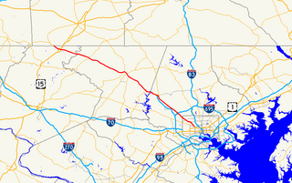
| Location | Baltimore, Baltimore County |
|---|---|
| Postal code | 21209, 21211, 21215, 21217, 21117, 21153, 21093 |
| North end | Tufton Avenue in Reisterstown |
| South end | Auchentoroly Terrace in Baltimore |
Greenspring Avenue is a road in Baltimore, Maryland and its northwestern suburbs. At one time, Greenspring Avenue was Maryland Route 519 from Worthington Road to Dover Road, but the road has since been decommissioned and no longer has any numerical designation. [1]
Greenspring Avenue is currently divided into three sections, as follows:
Greenspring Avenue begins inside of Druid Hill Park, near the Maryland Zoo. The first section, which is approximately 1.9 miles (3.1 km) long, is mostly lined with high-rise and garden apartments. This section ends at Northern Parkway, at Sinai Hospital, and across from Cylburn Park. From here, a left and then a right two blocks later is required to continue along Greenspring.
The next section of Greenspring Avenue starts off of Northern Parkway about one block west of Sinai Hospital, and continues for about 3/4 of a mile to a five-way intersection consisting of Cross Country Boulevard and Pimlico Road, in an area known as Cheswolde. A right turn is required here to continue along Greenspring.
The third and longest section of Greenspring Avenue continues from this intersection for about 10 miles (16 km) until the end of the name Greenspring Avenue for the road. However, the road physically continues beyond this point and is known as Worthington Avenue for the next mile and a half. It finally continues into Butler Road (Maryland Route 128) before it reaches Hanover Pike (Maryland Route 30), at which point going straight will lead to I-795. This section of the road can be accessed from the Baltimore Beltway at exit 22.
This section needs expansion. You can help by adding to it.(March 2009) |
The Green Spring Avenue Company was chartered in 1858 to build the portion south of Maryland Route 130 as a turnpike.

Throughout the 2000s, construction has been underway for a new development now known as Quarry Lake at Greenspring, which is located between Old Court Road and Smith Avenue.
In 2005, a rock-breaking ceremony was held. [2]
In 2006 and 2007, some commercial properties on the premises opened, including medical office space of Lifebridge Health, Walgreens, and The Fresh Market.
The development also features 83 single-family homes and 500 condos.
The center of the development features is 40-acre (160,000 m2) lake, which is 500 feet (150 m) deep, one of the deepest lakes in the state of Maryland. [3]
Public transportation, provided by the Maryland Transit Administration, is available on or near parts of Greenspring Avenue.
U.S. Route 140 was a U.S. highway connecting Gettysburg, Pennsylvania to Baltimore, Maryland. The route was deleted from the system in 1979; today the road's route is followed by portions of Pennsylvania Route 97, Maryland Route 97, and Maryland Route 140.
Interstate 395 (I-395) is an Interstate Highway in the U.S. state of Maryland. Known as Cal Ripken Way, the highway runs 1.33 miles (2.14 km) from I-95 north to Howard Street and Camden Street in Baltimore. I-395 is a spur that heads north from I-95 over the Middle Branch of the Patapsco River toward Downtown Baltimore, where it provides access to the Inner Harbor and the Baltimore Convention Center. The Interstate also serves the Camden Yards Sports Complex, which contains M&T Bank Stadium and Oriole Park at Camden Yards, homes of the Baltimore Ravens and Baltimore Orioles, respectively. I-395 also serves as the southern terminus of Martin Luther King Jr. Boulevard, an urban arterial that provides a western bypass of downtown Baltimore and connects I-95 with U.S. Route 40, US 1, and I-83. The Interstate is maintained by the Maryland Transportation Authority (MDTA) and, like all Interstates, is a part of the National Highway System.

Mount Washington is an area of northwest Baltimore, Maryland. It is a designated city historic district and divided into two sections: South Road/Sulgrave to the southeast and Dixon's Hill to the north. The Mount Washington Historic District was listed on the National Register of Historic Places in 1990 with a boundary increase in 2001, with five contributing buildings and four contributing structures.

Maryland Route 41 is a state highway in the U.S. state of Maryland. Known for most of its length as Perring Parkway, the state highway runs 6.75 miles (10.86 km) from MD 147 in Baltimore north to Waltham Woods Road in Carney. MD 41 is a four- to six-lane divided highway that connects portions of Northeast Baltimore, including Morgan State University, with Parkville and Interstate 695 (I-695). The state highway is maintained by the Maryland State Highway Administration in Baltimore County and the Baltimore City Department of Transportation in the city, where it is unsigned. MD 41 was built in the early to mid-1960s, largely to relieve congestion on portions of neighboring Old Harford and Harford Roads during the period of rapid post-World War II growth in the area.
Maryland Route 140 is a 49-mile (79 km) state highway in the U.S. state of Maryland.

Route 1 is a bus route operated by the Maryland Transit Administration in Baltimore. The line currently runs from Fort McHenry to Sinai Hospital, with some trips making short turns at the Mondawmin Metro Subway Station. The bus route is the successor to the 1 Gilmor Street, 2 Carey Street, and 2 Fort Avenue streetcar lines.

Park Heights is an area of Baltimore City, Maryland, that lies approximately 10 miles northwest of downtown Baltimore and within two miles of the Baltimore County line. A 1,500-acre community, Park Heights comprises 12 smaller neighborhoods that together contain approximately 30,000 residents. It is bounded on the south by Druid Park Drive, on the west by Wabash Avenue, on the east by Greenspring Avenue, and on the north by Northern Parkway. Interstate-83 is less than a half mile to the east. Two major roadways—Park Heights Avenue and Reisterstown Road—run north-south through Park Heights, serving as the neighborhood's "Main Streets" as well as commuter corridors. Limited commercial uses—primarily retail—are scattered along these roads; there is also some industrial activity on the neighborhood's western edge.

Maryland Route 129 is a state highway in the U.S. state of Maryland, running north-northwesterly from Baltimore into Baltimore County, ending east of Reisterstown. The route leaves downtown on the one-way pair of McCulloh Street and Druid Hill Avenue, and then uses the entire length of Park Heights Avenue to the end. MD 129 connects Downtown Baltimore with Druid Hill Park using McCulloh Street and Druid Hill Avenue. As Park Heights Avenue, the state highway is one of two primary radial routes in the northwestern part of the city, providing access to The Maryland Zoo and Pimlico Race Course. In Baltimore County, MD 129 passes through Pikesville, where it has a junction with Interstate 695 (I-695) and serves an affluent rural area north of Pikesville and east of Reisterstown.
Northern Parkway is a major road that runs west–east across the northern part of the city Baltimore. For most of the way, it is at least six lanes wide, and it is used by motorists for crosstown travel. It is designated E. Northern Pkwy and W. Northern Pkwy with Charles Street being the dividing line. It was constructed in the 1950s through several neighborhoods and several homes were razed in the process from right-of-way. The section of E. Northern Pkwy from Harford Road to Fleetwood Ave was originally called German Lane.
Joppa Road is a county highway in the U.S. state of Maryland. The highway extends 14.3 miles (23.0 km) from Maryland Route 25 in Brooklandville east to MD 7 near White Marsh. Joppa Road has three main segments separated by very short breaks on its course through central and eastern Baltimore County. The central segment is a multi-lane highway from MD 45 and MD 146 in the county seat of Towson to U.S. Route 1 in Perry Hall. This highway is mostly a commercial strip and parallels Interstate 695 (I-695) through Towson, Parkville, and Carney. The western and eastern segments of Joppa Road are two-lane roads through mainly residential areas. The western segment connects Brooklandville and Towson via Riderwood. The eastern segment serves parts of Perry Hall and White Marsh.
Rogers Avenue station is a Metro SubwayLink station in Baltimore, Maryland. It is located in the Arlington area, and is the fifth most northern and western station on the line, with approximately 900 parking spaces. It is a hub for several Maryland Transit Administration bus lines operating in various directions around the city, including routes:

Route 44 is a bus route operated by the Maryland Transit Administration in Baltimore and its suburbs. The line currently runs from Rosedale Industrial Park near Pulaski Highway just outside the Baltimore city limits on the east side of the city across the northern portion of the city to Security Square Mall, with selected peak hour trips to the Social Security Administration. Some early morning trips before 7 AM lay over at the Centers for Medicare and Medicaid Services (CMS) headquarters. The line operates mostly along Frankford Avenue, Echodale Avenue, East Belvedere Avenue, Northern Parkway, Rogers Avenue, and Gwynn Oak Avenue, serving the communities of Gardenville, Hamilton, Belvedere Park, Homeland, Roland Park, Pimlico, and Arlington, and the western suburb of Woodlawn.

Route 58 is a bus route operated by the Maryland Transit Administration in Baltimore and its suburbs. The line's western terminus is the Reisterstown Plaza Metro Subway Station, and its eastern terminus is White Marsh Mall, though some peak hour trips make short turns in Overlea. Route 58 serves the communities of Glen, Cheswolde, Fallstaff, a large section of Northern Parkway, and a portion of Belair Road in Baltimore County.

Sinai Hospital is an American private hospital based in Baltimore, Maryland, that was founded in 1866 as the Hebrew Hospital and Asylum. It is now a Jewish-sponsored teaching hospital that provides care for patients in the greater Baltimore City, Baltimore County and surrounding communities. The implantable cardioverter-defibrillator (ICD) was invented here by the team of Dr. Michel Mirowski, Dr. Morton Mower, M. Stephen Heilman, and Alois Langer who are all in the National Inventors Hall of Fame for their achievement.

LocalLink 92 is a school-day only bus route operated by the Maryland Transit Administration in Baltimore. The line currently runs from Glen Avenue and Key Avenue in Northwest Baltimore to Smith Avenue and Copper Ridge Road in Mount Washington or Old Court Road and Scotts Hill Drive in Pikesville.

Edgecomb, also known as Parklane, is a neighborhood in the North District of Baltimore, located between the neighborhoods of Cylburn (north) and Greenspring (south). Its boundaries are marked by Dupont Avenue (north), Coldspring Lane (south), Pimlico Road (west) and Greenspring Avenue (east). Central Park Heights, is located on the opposite side of Pimlico Road in the Northwest District. The neighborhood of Coldspring is located to Edgecomb's east, across Greenspring Avenue.

Cylburn is a neighborhood in the North District of Baltimore, located between the neighborhoods of Levindale (north) and Edgecomb (south). Its boundaries are marked by Cylburn Avenue (north), Dupont Avenue (south), Pimlico Road (west) and Greenspring Avenue (east). Central Park Heights, is located on the opposite side of Pimlico Road in the Northwest area of Baltimore City. Cylburn Arboretum and the neighborhood of Cold Spring are located to Cylburn's east, across Greenspring Avenue. The heavily wooded property with its historic mansion and grounds, walking trails, famous collections and gardens overlook the Jones Falls Valley with the Jones Falls Expressway further to the east.
Greenspring is a neighborhood in the North District of Baltimore, located between the neighborhoods of Woodberry (east) and Central Park Heights (west). Its boundaries are marked by West Cold Spring Lane (north), Greenspring Avenue (east), and Springhill Avenue (south). The western edge of the neighborhood runs along Pimlico Road from West Cold Spring Lane to Park Heights Avenue, then along Park Heights Avenue to Springhill Avenue.

Jones Falls Trail is a hiking and bicycling trail in Baltimore, Maryland. It mostly runs along the length of the namesake Jones Falls, a major north–south stream in and north of the city that has long acted as a major transportation corridor for the city. It also incorporates the bike path encircling Druid Hill Reservoir and its namesake park. The Jones Falls Trail forms a segment of the East Coast Greenway, a partially completed network of off-road bicycling routes that runs the length of the East Coast.
Cold Spring, also known as Coldspring, is a neighborhood in the North District of Baltimore, located between Cylburn (west) and the Village of Cross Keys (east). Its boundaries are drawn by West Northern Parkway (north), Greenspring Avenue (west), Jones Falls Expressway (east) and West Cold Spring Lane (south). Cold Spring Park covers about two-thirds of the neighborhood, running from Cold Spring's northern tip, where the Jones Falls Expressway crosses over West Northern Parkway, and overlapping the neighborhood's southern edge at West Cold Spring Lane.
Coordinates: 39°22′42.95″N76°41′2.91″W / 39.3785972°N 76.6841417°W