War Memorial Plaza

Last updated
Limestone horse and eagle at the War Memorial building War memorial horse & eagle.jpg
Limestone horse and eagle at the War Memorial building

War Memorial Plaza is a public square, small park and space in Downtown Baltimore between City Hall and the War Memorial Building, between Holliday Street on the west, East Fayette Street on the south, North Gay Street on the east, and East Lexington Street on the north.

Contents

History

On the northwest corner of the present square facing the intersection of Holliday and East Lexington Streets were a set of townhouses that were the sites for the opening of Loyola High School and Loyola College in 1852 by the Roman Catholic Society of Jesus (Jesuits). After a brief time, the two institutions relocated in 1855 to the west side of North Calvert Street between East Madison and Monument Streets in a large central Italianate building with a front portico connected to St. Ignatius Roman Catholic Church which had been recently completed on the north. They remained here (along with a large similarly styled addition to the south along East Monument Street in the 1890s) until the mid-20th Century with the College relocating in 1922 to its present "Evergreen" campus in North Baltimore City near Homeland community at North Charles Street and East Cold Spring Lane, next door to the landmark "Evergreen Mansion", (of the Garrett Family railroad and financier family giants) and the High School moved in 1934/1941 to "Blakefield" in west Towson, north of the city in Baltimore County. Inala 1975, the old Loyola complex was converted into a performing arts center for the decade-old Center Stage, which had relocated after a fire the previous year at their space on East North Avenue, between Charles and Calvert Streets.

A few doors to the south in the middle of the block was "Prof. Knapp's School", attended by many German immigrant students including the noted Henry Louis Mencken, (1880-1956), the famed "Baltimore Sun" newspaper reporter, editor, columnist, author and linguist in the late 1880s, just before he graduated and went on to the former "Baltimore Manual Training School" (founded 1883) in the late 1890s (now renamed 1893) the Baltimore Polytechnic Institute on the east side of Courtland Street [presently St. Paul Place and Street] - now near "Preston Gardens" opposite the site of Mercy Hospital (now Mercy Medical for Center).

War Memorial Plaza in 1927 Dedicating War Memorial (1927) (cropped).png
War Memorial Plaza in 1927

From its dedication in 1875 to 1917, the new second Baltimore City Hall faced the also the second building of the famed "Old Drury", the nickname of the Holliday Street Theatre rebuilt in brick and stone in 1813, (replacing first playhouse built of wood in 1795), designed by famous local architect Robert Cary Long, with a front facade in stone of Greek Revival style which was the most notable playhouse in Baltimore for decades. It is said that the first public singing of the future National Anthem reputedly by Ferdinand Durang, (c.1785-1831), occurred on the stage here in late September 1814, near the end of the War of 1812, when the poem of "The Defence of Fort McHenry" written by American Georgetown lawyer and amateur poet Francis Scott Key, when he was on board an American truce ship anchored downriver on the lower Patapsco River from the British Royal Navy fleet as it bombarded Fort McHenry on Whetstone Point guarding Baltimore Harbor during September 12–14, 1814 several weeks earlier and set to music with the tune "To An Anacreon in Heaven", a so-called English social society drinking song. It was also reputedly said to be re-sung lustily by the "after-the-show" crowd at the next door Theatre Tavern, (to the south, towards East Fayette Street between and adjacent to the "Assembly Rooms" on the corner) of Captain McCauley.

To its south at the northeast intersection of Holliday with East Fayette Street was the landmark "Old Assembly-Rooms", built also in 1799 by Robert Cary Long, Sr. of Georgian/Federal styled architecture for the old Baltimore Dancing Assembly, founded in the 1780s with elaborate decorative chambers and drawing rooms for social dancing, receptions and levees for the upper middle class ladies and gentlemen of the era. On its upper floor were housed the influential Library Company of Baltimore - a non-circulating subscription library founded in the late 1790s and later supplemented with the adjacent Mercantile Library. So the landmark structure was the center of social, cultural and intellectual activities in the growing Baltimore Town. By the mid-1840s, with the later addition of a third floor replacing its original pitched roof with a pointed stone pediment facing its Fayette Street south side and now with a flat roof with a stone balustrade earlier in 1835, (for illustration of remodeled building, see "Wikipedia" entry for "Baltimore City College"), the "Rooms" were occupied by the young men of the then decade-old "Central High School of Baltimore", later renamed the "Baltimore City College" in 1866. Founded in 1839, a few blocks away to the northwest on Courtland Street (now St. Paul Street/Place/Preston Gardens, C.H.S. (now the B.C.C.) was later considered to be the third oldest public high school in America.

Both influential landmark structures were destroyed in a large disastrous fire in 1873, and the Central High School later moved to new quarters especially built for it by for the first time by 1875 of Tudor Revival/Jacobethan Revival style of building at the southwest corner of North Howard and West Centre Streets, but the venerable Holliday Street Theatre was rebuilt on its original site and later owned by the famous John T. Ford, (1829–1894), local politician/municipal board member and East Coast playhouse operator, who was also proprietor of the infamous Ford's Theatre in Washington, D.C. where 16th President Abraham Lincoln was assassinated in April 1865 after the end of the American Civil War (1861–1865).

Two years after being rebuilt, the theatre was overwhelmed by the massive sized pile of marble and granite French Second Empire styled architecture with construction across the street to the west in the new domed Baltimore City Hall of 1867–1875 by George A. Frederick, (1842–1924), a municipal architect who also designed a lot of the structures in the new Druid Hill Park (established 1860) and other city structures. By the time that the theater and its surrounding block (Holliday to Fayette to North Gay to East Lexington Streets) was torn down in 1917, based on the 1910 plans of Frederick Law Olmsted, to make room for the newly laid-out War Memorial Plaza and Building, as a major rearrangement of a proposed new "civic center" of flanking municipal office buildings and structures providing additional space to be used in future decades, covering up the then unsightly canalized stream of Jones Falls to the east with its periodic flooding problems, and to open up a vista of the elaborate east front of the Baltimore City Hall, an influence of the then-nationwide "City Beautiful" movement among architects and city planners then coming to rise. [1] The War Memorial Building was designed by local famous architect Laurence Hall Fowler and originally dedicated to Marylanders who died in World War I and built in the early 1920s, dedicated 1925 and is one of many World War I Memorials for "The Great War" throughout the world built in the various participating Allied nations since the conflict of 1914–1918.

Present

"Negro soldier" statue by sculptor James E. Lewis from 1971 in front of east side of City Hall, relocated 2007 from Battle Monument Square Negro soldier.jpg
"Negro soldier" statue by sculptor James E. Lewis from 1971 in front of east side of City Hall, relocated 2007 from Battle Monument Square

War Memorial Plaza is a major component of Baltimore's municipal center (aka "civic center") now officially referred to as the Business and Government Historic District [2] and is included in Baltimore National Heritage Area, under sponsorship of the city, State and the National Park Service of the U.S. Department of the Interior. [3]

The plaza contains the statue "Negro Soldier", also originally called the "Negro War Heroes Monument". It was created by local sculptor James E. Lewis (a gallery of art at Morgan State University in northeast Baltimore is dedicated to him) in 1971. The statue originally sited at the north end, facing up North Calvert Street at the Battle Monument Square between East Lexington and East Fayette Streets, two blocks west) was relocated to War Memorial Plaza in 2007 after 30 years of facing the wrong way on a one-way street. [4] [5] [6]

Related Research Articles

<span class="mw-page-title-main">Great Baltimore Fire</span> 1904 fire in Baltimore, Maryland, United States

The Great Baltimore Fire raged in Baltimore, Maryland from Sunday, February 7, to Monday, February 8, 1904. More than 1,500 buildings were completely leveled, and some 1,000 severely damaged, bringing property loss from the disaster to an estimated $100 million. 1,231 firefighters helped bring the blaze under control, both professional paid truck and engine companies from the Baltimore City Fire Department (B.C.F.D.) and volunteers from the surrounding counties and outlying towns of Maryland, as well as out-of-state units that arrived on the major railroads. It destroyed much of central Baltimore, including over 1,500 buildings covering an area of some 140 acres (57 ha).

<span class="mw-page-title-main">Westminster Hall and Burying Ground</span> Historic district in Maryland, United States

Westminster Hall and Burying Ground is a graveyard and former church located at 519 West Fayette Street in Baltimore, Maryland, United States. It occupies the southeast corner of West Fayette and North Greene Street on the west side of downtown Baltimore. It sits across from the Baltimore VA hospital and is the burial site of Edgar Allan Poe (1809–1849). The complex was declared a national historic district in 1974.

Defenders Day is a longtime legal holiday on September 12, in the U.S. state of Maryland, in the City of Baltimore and surrounding Baltimore County. It commemorates the successful defense of the city of Baltimore on September 12-13-14, 1814 from an invading British force during the War of 1812, an event which led to the writing of the words of a poem, which when set to music a few days later, became known as "The Star-Spangled Banner", which in 1931 was designated as the national anthem of the United States.

<span class="mw-page-title-main">Peale Museum</span> Museum in Baltimore, Maryland, US

The Peale, located in Baltimore, Maryland, is Baltimore's Community Museum. Its mission is to evolve the role of museums in society by providing local creators and storytellers with the space and support the need to realize a complete and accessible cultural legacy for the city of Baltimore. In August 2022, The Peale held a grand re-opening ceremony after the completion of a five-year restoration process.

<span class="mw-page-title-main">Severn Teackle Wallis</span> American politician

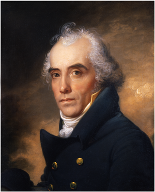
Severn Teackle Wallis was an American lawyer and politician.

<span class="mw-page-title-main">Flag of Baltimore</span> Flag of the city of Baltimore, Maryland, US

The flag of the city of Baltimore features the "Battle Monument", which is also the central motif on the city's seal.

St. Paul Street and Calvert Street are a one-way pair of streets in Downtown Baltimore and areas north. The streets, which are part of Maryland Route 2, are two of Baltimore's best-known streets in the downtown area.

<span class="mw-page-title-main">Battle Monument</span> Monument in Baltimore, Maryland, U.S.

The Battle Monument, located in Battle Monument Square on North Calvert Street between East Fayette and East Lexington Streets in Baltimore, Maryland, commemorates the Battle of Baltimore with the British fleet of the Royal Navy's bombardment of Fort McHenry, the Battle of North Point, southeast of the city in Baltimore County on the Patapsco Neck peninsula, and the stand-off on the eastern siege fortifications along Loudenschlager and Potter's Hills, later called Hampstead Hill, in what is now Patterson Park since 1827, east of town. It honors those who died during the month of September 1814 during the War of 1812. The monument lies in the middle of the street and is between the two Baltimore City Circuit Courthouses that are located on the opposite sides of North Calvert Street. It was sponsored by the City and the "Committee of Vigilance and Safety" led by Mayor Edward Johnson and military commanders: Brig. Gen. John Stricker, Maj. Gen. Samuel Smith and Lt. Col. George Armistead.

<span class="mw-page-title-main">Baltimore City Circuit Courthouses</span> Building in Baltimore City, United States of America

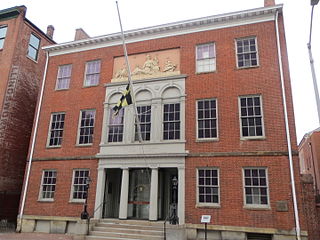
The Baltimore City Circuit Courthouses are state judicial facilities located in downtown Baltimore, Maryland. They face each other in the 100 block of North Calvert Street, between East Lexington Street on the north and East Fayette Street on the south across from the Battle Monument Square (1815-1822), which held the original site of the first colonial era courthouse for Baltimore County and Town, after moving the Baltimore County seat in 1767 to the burgeoning port town on the Patapsco River established in 1729-1730.

<span class="mw-page-title-main">Baltimore City Hall</span> Official seat of government of Baltimore, Maryland, US

Baltimore City Hall is the official seat of government of the City of Baltimore, in the State of Maryland. The City Hall houses the offices of the Mayor and those of the City Council of Baltimore. The building also hosts the city Comptroller, some various city departments, agencies and boards/commissions along with the historic chambers of the Baltimore City Council. Situated on a city block bounded by East Lexington Street on the north, Guilford Avenue on the west, East Fayette Street on the south and North Holliday Street with City Hall Plaza and the War Memorial Plaza to the east, the six-story structure was designed by the then 22-year-old new architect, George Aloysius Frederick (1842–1924) in the Second Empire style, a Baroque revival, with prominent Mansard roofs with richly-framed dormers, and two floors of a repeating Serlian window motif over an urbanely rusticated basement.

<span class="mw-page-title-main">Baltimore County Circuit Courthouses</span> United States historic place

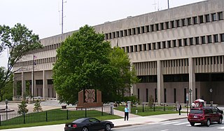
The Baltimore County Courthouses are located in Towson, the county seat. The older, original Baltimore County Courthouse of 1854-1856 houses many of the offices of the County government, including both the executive branch and the legislative branch. The County Courts Building lies to the west, separated by a plaza. Built in 1970-1971, it houses the civil, criminal, family and juvenile divisions of the Circuit Court of Maryland for Baltimore County, as well as the Baltimore County Sheriff's Office. The latter office protects the Courthouse and its judicial personnel, as well as having countywide law enforcement functions.

<span class="mw-page-title-main">First Unitarian Church (Baltimore, Maryland)</span> United States historic place

The First Unitarian Church is a historic church and congregation at 12 West Franklin Street in Mount Vernon, Baltimore, Maryland. Dedicated in 1818, it was the first building erected for Unitarians in the United States. The church is a domed cube with a stucco exterior. The church, originally called the "First Independent Church of Baltimore", is the oldest building continuously used by a Unitarian congregation. The name was changed in 1935 to "The First Unitarian Church of Baltimore " following the merger with the former Second Universalist Church at East Lanvale Street and Guilford Avenue in midtown Baltimore. The American Unitarian Association and the Universalist Church of America (established 1866) representing the two strains of Unitarian Universalism beliefs and philosophies merged as a national denomination named the Unitarian Universalist Association in May 1961.

<span class="mw-page-title-main">Seton Hill, Baltimore</span> United States historic place

Seton Hill Historic District is a historic district in Baltimore, Maryland. It was listed on the National Register of Historic Places in 1975.

The Baltimore bank riot of 1835 in the major port city of Maryland was a violent reaction to the failure of the Bank of Maryland in 1834. Thousands of citizens had lost millions of dollars in savings. The riot, which lasted from 6 to 9 August, attacked the homes and property of a number of former directors of the bank, who had been accused of financial misconduct and fraud, as well as the federal district courthouse located on Battle Monument Square. The Baltimore bank riot was one of the most violent and destructive events of civic unrest in any American city prior to the Civil War.

<span class="mw-page-title-main">St. Paul's Episcopal Church (Baltimore, Maryland)</span> Historic church in Maryland, United States

St. Paul's Protestant Episcopal Church, more commonly called Old St. Paul's Church today, is a historic Episcopal church located at 233 North Charles Street at the southeast corner with East Saratoga Street, in Baltimore, Maryland, near "Cathedral Hill" on the northern edge of the downtown central business district to the south and the Mount Vernon-Belevedere cultural/historic neighborhood to the north. It was founded in 1692 as the parish church for the "Patapsco Parish", one of the "original 30 parishes" of the old Church of England in colonial Maryland.

<span class="mw-page-title-main">Maximilian Godefroy</span> French-American architect

J. Maximilian M. Godefroy was a French-American architect. Godefroy was born in France and educated as a geographical/civil engineer. During the French Revolution he fought briefly on the Royalist side. Later, as an anti-Bonaparte activist, he was imprisoned in the fortress of Bellegarde and Château d'If then released about 1805 and allowed to come to the United States, settling in Baltimore, Maryland, where he became an instructor in drawing, art and military science at St. Mary's College, the Sulpician Seminary. By 1808, Godefroy had married Eliza Crawford Anderson, editor of her own periodical, the Observer and the niece of a wealthy Baltimore merchant.

<span class="mw-page-title-main">Charles Center</span> Neighborhood of Baltimore in Maryland, United States

Charles Center is a large-scale urban redevelopment project in central Baltimore's downtown business district of the late 1950s and early 1960s. Beginning in 1954, a group called the "Committee for Downtown" promoted a master plan for arresting the commercial decline of central Baltimore. In 1955, the "Greater Baltimore Committee", headed by banker and developer James W. Rouse, joined the effort. A plan was developed by noted American urban planner and architect David A. Wallace, (1917−2004), strongly supported by Mayors Thomas L. J. D'Alesandro, Jr. (1947−1959) and Theodore R. McKeldin, and many in their administrations, which formed the basis of a $25 million bond issue voted on by the citizens of Baltimore City during the municipal elections in November 1958. The architects' view of the overall Charles Center Redevelopment Plan with the conceptions of possible buildings, lay-out and plan that was publicized to the voters that spring and summer before, only slightly resembles the actual buildings and designs that later were really constructed by the mid-1970s.

The Baltimore City Heritage Walk is a heritage trail that links 20 historic sites and museums in downtown Baltimore, Maryland.

<span class="mw-page-title-main">Zion Lutheran Church (Baltimore, Maryland)</span> Historic church in Maryland, United States

Zion Lutheran Church, also known as the Zion Church of the City of Baltimore, is a historic Evangelical Lutheran church located in downtown Baltimore, Maryland, United States, founded 1755.

References

  1. "Holliday Street Theater". The Cambridge Guide to American Theatre (2 ed.). Cambridge University Press. 2007. p. 331. ISBN   9780521835381. It was pulled down in 1813 and a new theater built on the site; this the city of Baltimore razed in 1917 to construct War Memorial Plaza
  2. "Business and Government Historic District". Maryland Historical Trust. Retrieved March 12, 2012.
  3. "Baltimore National Heritage Area Map" (PDF). City of Baltimore. Retrieved March 11, 2012.
  4. Kane, Gregory (January 13, 2007). "Long-ignored memorial makes a prominent move: New home chosen for statue honoring black soldiers". Baltimore Sun. Retrieved August 6, 2012. No work of Dr. Lewis' was more controversial than his 1972 sculpture, the 'Black Soldier,' " noted a Sun editorial of Aug. 12, 1997. "Its 1971 placement in Battle Monument Plaza was opposed by critics who thought the statue was inappropriate at a memorial to those who fought in the 1814 Battle of North Point or argued that no more tributes to the military were needed at all.
  5. "Negro Soldier - Baltimore, MD". Waymark. Retrieved August 6, 2012. The sculpture was commissioned by an anonymous donor as a gift to the City of Baltimore. The cost was $30,000. Controversy arose over the original placement of the statue at the site of the Battle Monument (IAS 75005996). Some felt that the addition of any sculpture to Battle Monument Plaza would diminish the significance of the "Battle Monument", the City's first monument to the War of 1812 of those killed during the Battle of Baltimore - with the bombardment of Fort McHenry and the Battle of North Point in southeastern Baltimore County, and reportedly the nation's first memorial to the common soldiers and officers of its war dead. Others raised concerns that a monument, which was representative of only one ethnic group as opposed to an individual or the entire group of 1814 war casualties, would have a polarizing effect in the City and racial relations.
  6. "Negro Heroes of the US". Fieldguide to U.S. Public Monuments and Memorials. 2011. Retrieved August 6, 2012.

Coordinates: 39°17′27″N76°36′35″W / 39.2909°N 76.60964°W / 39.2909; -76.60964