
Pikesville is a census-designated place (CDP) in Baltimore County, Maryland, United States. Pikesville is just northwest of the Baltimore city limits. It is the northwestern suburb closest to Baltimore.
Interstate 795 (I-795), also known as the Northwest Expressway, is a nine-mile freeway linking Baltimore's northwestern suburbs of Pikesville, Owings Mills and Reisterstown, Maryland to the Baltimore Beltway. The route bypasses Maryland Route 140, carrying part of MTA Maryland's Baltimore Metro SubwayLink in its median for a four-mile stretch, and provides direct access to the former Owings Mills Mall. It never connects to its parent, I-95, except via I-695.
U.S. Route 140 was a U.S. highway connecting Gettysburg, Pennsylvania to Baltimore, Maryland. The route was deleted from the system in 1979; today the road's route is followed by portions of Pennsylvania Route 97, Maryland Route 97, and Maryland Route 140.

The Metro SubwayLink is a rapid transit line serving the greater area of Baltimore, Maryland, in the United States, and is operated by the Maryland Transit Administration. More than half of the line is underground, and most of the line outside the central city is elevated or at surface grade. In 2021, the line had a ridership of 1,667,400, or about 5,600 per weekday as of the fourth quarter of 2021.

Mount Washington is an area of northwest Baltimore, Maryland. It is a designated city historic district and divided into two sections: South Road/Sulgrave to the southeast and Dixon's Hill to the north. The Mount Washington Historic District was listed on the National Register of Historic Places in 1990 with a boundary increase in 2001, with five contributing buildings and four contributing structures.
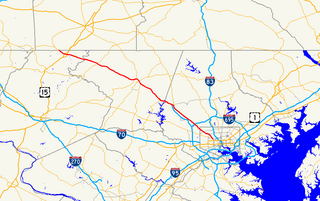
Maryland Route 140 is a 49-mile (79 km) state highway in the U.S. state of Maryland. The route runs from U.S. Route 1 and US 40 Truck in Baltimore northwest to the Pennsylvania border, where the road continues into that state as Pennsylvania Route 16. MD 140 passes through the northern part of central Maryland, connecting Baltimore, Pikesville, Reisterstown, Westminster, Taneytown, and Emmitsburg.

Maryland Route 129 is a state highway in the U.S. state of Maryland, running north-northwesterly from U.S. Route 40 and MD 295 in Baltimore into Baltimore County, ending at Garrison Forest Road east of Reisterstown. The route leaves downtown on the one-way pair of McCulloh Street and Druid Hill Avenue, and then uses the entire length of Park Heights Avenue to the end. MD 129 connects Downtown Baltimore with Druid Hill Park using McCulloh Street and Druid Hill Avenue. As Park Heights Avenue, the state highway is one of two primary radial routes in the northwestern part of the city, providing access to The Maryland Zoo and Pimlico Race Course. In Baltimore County, MD 129 passes through Pikesville, where it has a junction with Interstate 695 (I-695) and serves an affluent rural area north of Pikesville and east of Reisterstown.
Northern Parkway is a major road that runs west–east across the northern part of the city Baltimore. For most of the way, it is at least six lanes wide, and it is used by motorists for crosstown travel. It is designated E. Northern Pkwy and W. Northern Pkwy with Charles Street being the dividing line. It was constructed in the 1950s through several neighborhoods and several homes were razed in the process from right-of-way. The section of E. Northern Pkwy from Harford Road to Fleetwood Ave was originally called German Lane.

Route 7 was a bus route operated by the Maryland Transit Administration in Baltimore. The line, which operated between 1959 and 2017, ran from Canton, Baltimore to the Mondawmin Metro Subway Station, serving the communities of Butcher's Hill, Little Italy, and Sandtown-Winchester.
Route 5 is a bus route operated by the Maryland Transit Administration in Baltimore. The line currently runs from Cedonia in northeast Baltimore to the Mondawmin Metro Subway Station. The line has two alternating routes in East Baltimore: one via the area of Johns Hopkins Hospital, and one via a one-way pair of streets a few blocks north. A small number of trips also operate to/from Federal Street or Lanvale & Patterson Park.
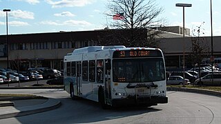
Old Court Road is a state- and county-maintained highway in the U.S. state of Maryland. Including the adjacent road in Howard County known as Woodstock Road, the highway runs 15.4 miles (24.8 km) from Maryland Route 99 near Woodstock east to Joppa Road near Towson. Old Court Road includes two county-maintained sections and two Maryland state highways, Maryland Route 125 and Maryland Route 133. MD 125 has a length of 3.59 miles (5.78 km) between Woodstock and the edge of Randallstown and MD 133 spans 3.31 miles (5.33 km) between MD 129 and MD 25 in Pikesville. Old Court Road connects the western and central Baltimore County communities of Granite, Randallstown, Milford Mill, Pikesville, and Towson. Old Court Road has been a cross-county highway since the colonial era. The highway was fully paved in Baltimore County by the mid-1920s, including the sections of the highway that became MD 125 and MD 133. MD 133 was extended west to MD 140 and MD 125 was extended west to MD 99 in the early 1930s; MD 125's terminus returned to the Patapsco River in the mid-1950s. Old Court Road was relocated at its eastern end in the early 1960s and in Pikesville in the late 1960s, at which time MD 133 assumed its current course.

Wabash Avenue is a six-lane boulevard in northwest Baltimore, Maryland, that runs from Patterson Avenue to Hilton Street, mostly through the Arlington community, crossing over Northern Parkway and Cold Spring Lane along the way. The road starts near the Reisterstown Plaza Metro Subway Station and continues to just past the West Coldspring Metro Subway Station, where it narrows and becomes a one-way pair with Dorithan Road, which ends several blocks later at Hilton Street.
LocalLink 85 is a bus route that operates in Baltimore and its suburbs. All trips operate from the Penn-North Metro Subway Station in Baltimore City to the Milford Mill Metro Subway Station in Pikesville. The route, which started operating on August 24, 2008, is a combination of the most recent versions of the former routes M-3 and M-8, which had been operating since 1984 and 1987 respectively. Prior to these dates, the routes had been served by other buses and streetcars.

Route 58 is a bus route operated by the Maryland Transit Administration in Baltimore and its suburbs. The line's western terminus is the Reisterstown Plaza Metro Subway Station, and its eastern terminus is White Marsh Mall, though some peak hour trips make short turns in Overlea. Route 58 serves the communities of Glen, Cheswolde, Fallstaff, a large section of Northern Parkway, and a portion of Belair Road in Baltimore County.

Route 34 is a bus route operated by the Maryland Transit Administration in Baltimore and its suburbs. The line currently operates weekdays only from the Reisterstown Plaza Metro Subway Station to Stevenson University during peak hours and Greenspring Station midday.

LocalLink 89 is a bus route operated by the Maryland Transit Administration in Baltimore and its suburbs, mostly along Reisterstown Road. The line currently runs from the Reisterstown Plaza Metro Subway Station to the Owings Mills Town Center. The line replaced original Route 59 under BaltimoreLink, and was a split-off from Route M-9, and resembles the pre-1997 route of Route M-9. It is the successor to several other bus routes and streetcars.

LocalLink 87 is a bus route operated by the Maryland Transit Administration in the suburbs of Baltimore. The route currently runs from the Owings Mills Town Center to Glyndon via Reisterstown Road and the Owings Mills Metro Subway Station. The line, which was a split-off from the final version of the now defunct Route M-9, and resembles the former Route M-16 that operated from 1987 to 1998. The route was previously named No. 56 before BaltimoreLink, when it was replaced in its entirety by Route 87.

CityLink Lime is a CityLink bus route operated by the Maryland Transit Administration in Baltimore and its suburbs. The line currently runs from the Mondawmin Metro Subway Station along Liberty Heights Avenue and Liberty Road to a loop known as in Milford Mill with buses marked as "Milford Mill". The loop is composed of a square block, consisting of Liberty Road, Rolling Road, Church Lane, and Milford Mill Road. The spot of the layover depends on the time of day.
LocalLink 83 is a bus route in Baltimore and its suburbs. The line currently runs from the Old Court Metro Subway Station in Pikesville, Maryland to the Mondawmin Metro Subway Station in Northwest Baltimore along Old Court Road and Reisterstown Road, serving the communities of Park Heights and the Reisterstown Road Plaza. The line is the successor to Bus Route 7, which still operates south of Mondawmin. Route 7 operated along Reisterstown Road outside the Metro's hours of operation until 2001.

LocalLink 92 is a school-day only bus route operated by the Maryland Transit Administration in Baltimore. The line currently runs from Glen Avenue and Key Avenue in Northwest Baltimore to Smith Avenue and Copper Ridge Road in Mount Washington or Old Court Road and Scotts Hill Drive in Pikesville.
