The World Geodetic System (WGS) is a standard used in cartography, geodesy, and satellite navigation including GPS. The current version, WGS 84, defines an Earth-centered, Earth-fixed coordinate system and a geodetic datum, and also describes the associated Earth Gravitational Model (EGM) and World Magnetic Model (WMM). The standard is published and maintained by the United States National Geospatial-Intelligence Agency.

In satellite laser ranging (SLR) a global network of observation stations measures the round trip time of flight of ultrashort pulses of light to satellites equipped with retroreflectors. This provides instantaneous range measurements of millimeter level precision which can be accumulated to provide accurate measurement of orbits and a host of important scientific data. The laser pulse can also be reflected by the surface of a satellite without a retroreflector, which is used for tracking space debris.

The San Andreas Fault Observatory at Depth (SAFOD) was a research project that began in 2002 aimed at collecting geological data about the San Andreas Fault for the purpose of predicting and analyzing future earthquakes. The site consists of a 2.2 km pilot hole and a 3.2 km main hole. Drilling operations ceased in 2007. Located near the town of Parkfield, California, the project installed geophone sensors and GPS clocks in a borehole that cut directly through the fault. This data, along with samples collected during drilling, helped shed new light on geochemical and mechanical properties around the fault zone.
Satellite geodesy is geodesy by means of artificial satellites—the measurement of the form and dimensions of Earth, the location of objects on its surface and the figure of the Earth's gravity field by means of artificial satellite techniques. It belongs to the broader field of space geodesy. Traditional astronomical geodesy is not commonly considered a part of satellite geodesy, although there is considerable overlap between the techniques.

A satellite navigation or satnav system is a system that uses satellites to provide autonomous geopositioning. A satellite navigation system with global coverage is termed global navigation satellite system (GNSS). As of 2024, four global systems are operational: the United States's Global Positioning System (GPS), Russia's Global Navigation Satellite System (GLONASS), China's BeiDou Navigation Satellite System (BDS), and the European Union's Galileo.
The EarthScope project (2003-2018) was an National Science Foundation (NSF) funded earth science program that, from 2003-2018, used geological and geophysical techniques to explore the structure and evolution of the North American continent and to understand the processes controlling earthquakes and volcanoes. The project had three components: USArray, the Plate Boundary Observatory, and the San Andreas Fault Observatory at Depth. Organizations associated with the project included UNAVCO, the Incorporated Research Institutions for Seismology (IRIS), Stanford University, the United States Geological Survey (USGS) and National Aeronautics and Space Administration (NASA). Several international organizations also contributed to the initiative. EarthScope data are publicly accessible.

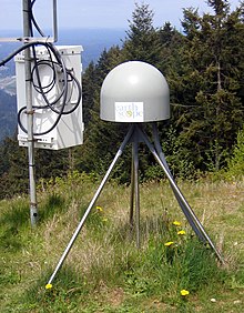
The Plate Boundary Observatory (PBO) was the geodetic component of the EarthScope Facility. EarthScope was an earth science program that explored the 4-dimensional structure of the North American Continent. EarthScope was a 15-year project (2003-2018) funded by the National Science Foundation (NSF) in conjunction with NASA. PBO construction took place from October 2003 through September 2008. Phase 1 of operations and maintenance concluded in September 2013. Phase 2 of operations ended in September 2018, along with the end of the EarthScope project. In October 2018, PBO was assimilated into a broader Network of the Americas (NOTA), along with networks in Mexico (TLALOCNet) and the Caribbean (COCONet), as part of the NSF's Geodetic Facility for the Advancement of Geosciences (GAGE). GAGE is operated by EarthScope Consortium.

GNSS reflectometry involves making measurements from the reflections from the Earth of navigation signals from Global Navigation Satellite Systems such as GPS. The idea of using reflected GNSS signals for earth observation was first proposed in 1993 by Martin-Neira. It was also investigated by researchers at NASA Langley Research Center and is also known as GPS reflectometry.
Augmentation of a global navigation satellite system (GNSS) is a method of improving the navigation system's attributes, such as precision, reliability, and availability, through the integration of external information into the calculation process. There are many such systems in place, and they are generally named or described based on how the GNSS sensor receives the external information. Some systems transmit additional information about sources of error, others provide direct measurements of how much the signal was off in the past, while a third group provides additional vehicle information to be integrated in the calculation process.
UNAVCO (University Navstar Consortium) was a non-profit university-governed consortium that facilitated geology research and education using geodesy.
Richard C. Aster is an American seismologist and is Professor of Geophysics and Department Head of Geosciences at Colorado State University.
The Cyclone Global Navigation Satellite System (CYGNSS) is a space-based system developed by the University of Michigan and Southwest Research Institute with the aim of improving hurricane forecasting by better understanding the interactions between the sea and the air near the core of a storm.

The Geodetic Observatory Wettzell is located atop the 616 meter-high mountain Wagnerberg, west of the village Wettzell in the German district Cham in the Bavarian Forest.
Dorota A. Grejner-Brzezińska is a Polish-American geodetic engineer known for her work on the Global Positioning System. She is University Distinguished Professor and Lowber B. Strange Endowed Chair in the Department of Civil, Environmental and Geodetic Engineering at Ohio State University, and director of the Satellite Positioning and Inertial Navigation at Ohio State, where she was also the Associate Dean for Research in the College of Engineering and senior associate vice president for research of the university. She current serves as Vice President of the Office of Knowledge Enterprise, part of Ohio State University's Enterprise for Research, Innovation and Knowledge.

MERMAID is a marine scientific instrument platform, short for Mobile Earthquake Recorder for Marine Areas by Independent Divers.
Thomas A. Herring is a geophysicist, known for developing and applying systems of space geodesy to high-precision geophysical measurements and geodynamic research.
The Seismological Facility for the Advancement of Geoscience(SAGE) is a distributed, multi-user national facility that provides state of-the-art seismic research. It is operated by the EarthScope Consortium. Its previous operator was the Incorporated Research Institutions for Seismology (IRIS), until its merger with UNAVCO to become the EarthScope Consortium. SAGE is one of the two premier geophysical facilities in support of geoscience and geoscience education of the National Science Foundation (NSF). The other premiere geophysical facility is GAGE, the Geodetic Facility for the Advancement of Geoscience.
The Polar Earth Observing Network (POLENET) is a global network involving researchers from 24 nations for the geophysical observation of the polar regions of our planet.
Continuously Operating Caribbean GPS Observational Network (COCONet) was a global positioning system (GPS) observation network that spanned across the Caribbean and the neighboring area It was part of UNAVCO (University Navstar Corporation). UNAVCO and IRIS (Incorporated Research Institutions for Seismology) Consortium later merged to create EarthScope Consortium in 2023.
The EarthScope Primary Instrument Center is a research center at New Mexico Institute of Mining and Technology for geophysics research in Earth system science. The facility provides instrumentation and support services for seismology experiments around the world, as well as those for the National Science Foundation and the U.S. Department of Energy.