Geopolitical ontology

Last updated

The FAO geopolitical ontology is an ontology developed by the Food and Agriculture Organization of the United Nations (FAO) to describe, manage and exchange data related to geopolitical entities such as countries, territories, regions and other similar areas.

Contents

Definitions and examples

An ontology is a kind of dictionary that describes information in a certain domain using concepts and relationships. It is often implemented using OWL (Web Ontology Language), an XML-based standard language that can be interpreted by computers.

Figure 1. An example of concepts and relationship in the geopolitical ontology. Concepts November 19 2008 v 2.png
Figure 1. An example of concepts and relationship in the geopolitical ontology.

The advantage of describing information in an ontology is that it enables to acquire domain knowledge by defining hierarchical structures of classes, adding individuals, setting object properties and datatype properties, and assigning restrictions.

FAO ontology

The geopolitical ontology provides names in seven languages (Arabic, Chinese, French, English, Spanish, Russian and Italian) and identifiers in various international coding systems (ISO2, ISO3, AGROVOC, FAOSTAT, FAOTERM [2] , GAUL, UN, UNDP and DBPediaID codes) for territories and groups. Moreover, the FAO geopolitical ontology tracks historical changes from 1985 up until today; [3] provides geolocation (geographical coordinates); implements relationships among countries and countries, or countries and groups, including properties such as has border with, is predecessor of, is successor of, is administered by, has members, and is in group; and disseminates country statistics including country area, land area, agricultural area, GDP or population.

The FAO geopolitical ontology provides a structured description of data sources. This includes: source name, source identifier, source creator and source's update date. Concepts are described using the Dublin Core vocabulary [4]

In summary, the main objectives of the FAO geopolitical ontology are:

It is possible to download the FAO geopolitical ontology in OWL [5] and RDF [6] formats. Documentation is available in the FAO Country Profiles Geopolitical information web page. [7]

Features of the FAO ontology

The geopolitical ontology contains :

Implementation into OWL

The FAO geopolitical ontology is implemented in OWL. It consists of classes, properties, individuals and restrictions. Table 1 shows all classes, gives a brief description and lists some individuals that belong to each class. Note that the current version of the geopolitical ontology does not provide individuals of the class "disputed" territories. Table 2 and Table 3 illustrate datatype properties and object properties.

Geopolitical ontology in Linked Open Data

The FAO Geopolitical ontology is embracing the W3C Linked Open Data (LOD) initiative [14] and released its RDF version of the geopolitical ontology in March 2011. The term 'Linked Open Data' refers to a set of best practices for publishing and connecting structured data on the Web. The key technologies that support Linked Data are URIs, HTTP and RDF.

The RDF version of the geopolitical ontology is compliant with all Linked data principles to be included in the Linked Open Data cloud, as explained in the following. [15] [16]

Resolvable http:// URIs

Every resource in the OWL format of the FAO Geopolitical Ontology has a unique URI. Dereferenciation was implemented to allow for three different URIs to be assigned to each resource as follows:

In addition the current URIs used for OWL format needed to be kept to allow for backwards compatibility for other systems that are using them. Therefore, the new URIs for the FAO Geopolitical Ontology in LOD were carefully created, using “Cool URIs for Semantic Web” and considering other good practices for URIs, such as DBpedia URIs.

New URIs

The URIs of the geopolitical ontology need to be permanent, consequently all transient information, such as year, version, or format was avoided in the definition of the URIs. The new URIs can be accessed [6]

For example, for the resource “Italy” the URIs are the following:

http://www.fao.org/countryprofiles/geoinfo/geopolitical/resource/Italy
identifies the non-information resource.
http://www.fao.org/countryprofiles/geoinfo/geopolitical/data/Italy
identifies the resource with an RDF/XML representation.
http://www.fao.org/countryprofiles/geoinfo/geopolitical/page/Italy
identifies the information resource with an HTML representation.

In addition, “owl:sameAs” is used to map the new URIs to the OWL representation.

Dereferencing URIs

When a non-information resource is looked up without any specific representation format, then the server needs to redirect the request to information resource with an HTML representation. For example, to retrieve the resource “Italy” [17] , which is a non-information resource, the server redirects to the HTML page of “Italy”. [18]

At least 1000 triples in the datasets

The total number of triple statements in FAO Geopolitical Ontology is 22,495. At least 50 links to a dataset already in the current LOD Cloud: FAO Geopolitical Ontology has 195 links to DBpedia, which is already part of the LOD Cloud.

Access to the entire dataset

FAO Geopolitical Ontology provides the entire dataset as a RDF dump. [19]

The RDF version of the FAO Geopolitical Ontology has been already registered in CKAN [20] and it was requested to add it into the LOD Cloud.

Example of use

Figure 3. a website of introducing the geopolitical ontology in FAO Country Profiles. Geopolitical Ontology in Country Profiles August 12 2009 v 1.png
Figure 3. a website of introducing the geopolitical ontology in FAO Country Profiles.

The FAO Country Profiles is an information retrieval tool which groups the FAO's vast archive of information on its global activities in agriculture and rural development in one single area and catalogues it exclusively by country.

The FAO Country Profiles system provides access to country-based heterogeneous data sources. [21] By using the geopolitical ontology in the system, the following benefits are expected: [22]

Figure 3 shows a page in the FAO Country Profiles where the geopolitical ontology is described.

See also

Related Research Articles

<span class="mw-page-title-main">Semantic Web</span> Extension of the Web to facilitate data exchange

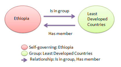
The Semantic Web, sometimes known as Web 3.0, is an extension of the World Wide Web through standards set by the World Wide Web Consortium (W3C). The goal of the Semantic Web is to make Internet data machine-readable.

In information science, an ontology encompasses a representation, formal naming, and definitions of the categories, properties, and relations between the concepts, data, or entities that pertain to one, many, or all domains of discourse. More simply, an ontology is a way of showing the properties of a subject area and how they are related, by defining a set of terms and relational expressions that represent the entities in that subject area. The field which studies ontologies so conceived is sometimes referred to as applied ontology.

The Resource Description Framework (RDF) is a World Wide Web Consortium (W3C) standard originally designed as a data model for metadata. It has come to be used as a general method for description and exchange of graph data. RDF provides a variety of syntax notations and data serialization formats, with Turtle currently being the most widely used notation.

<span class="mw-page-title-main">Topic map</span> Knowledge organization system

A topic map is a standard for the representation and interchange of knowledge, with an emphasis on the findability of information. Topic maps were originally developed in the late 1990s as a way to represent back-of-the-book index structures so that multiple indexes from different sources could be merged. However, the developers quickly realized that with a little additional generalization, they could create a meta-model with potentially far wider application. The ISO/IEC standard is formally known as ISO/IEC 13250:2003.

Reification is the process by which an abstract idea about a computer program is turned into an explicit data model or other object created in a programming language. A computable/addressable object—a resource—is created in a system as a proxy for a non computable/addressable object. By means of reification, something that was previously implicit, unexpressed, and possibly inexpressible is explicitly formulated and made available to conceptual manipulation. Informally, reification is often referred to as "making something a first-class citizen" within the scope of a particular system. Some aspect of a system can be reified at language design time, which is related to reflection in programming languages. It can be applied as a stepwise refinement at system design time. Reification is one of the most frequently used techniques of conceptual analysis and knowledge representation.

The Web Ontology Language (OWL) is a family of knowledge representation languages for authoring ontologies. Ontologies are a formal way to describe taxonomies and classification networks, essentially defining the structure of knowledge for various domains: the nouns representing classes of objects and the verbs representing relations between the objects.

RDF Schema (Resource Description Framework Schema, variously abbreviated as RDFS, RDF(S), RDF-S, or RDF/S) is a set of classes with certain properties using the RDF extensible knowledge representation data model, providing basic elements for the description of ontologies. It uses various forms of RDF vocabularies, intended to structure RDF resources. RDF and RDFS can be saved in a triplestore, then one can extract some knowledge from them using a query language, like SPARQL.

SPARQL is an RDF query language—that is, a semantic query language for databases—able to retrieve and manipulate data stored in Resource Description Framework (RDF) format. It was made a standard by the RDF Data Access Working Group (DAWG) of the World Wide Web Consortium, and is recognized as one of the key technologies of the semantic web. On 15 January 2008, SPARQL 1.0 was acknowledged by W3C as an official recommendation, and SPARQL 1.1 in March, 2013.

A web resource is any identifiable resource present on or connected to the World Wide Web. Resources are identified using Uniform Resource Identifiers (URIs). In the Semantic Web, web resources and their semantic properties are described using the Resource Description Framework (RDF).

RDFa or Resource Description Framework in Attributes is a W3C Recommendation that adds a set of attribute-level extensions to HTML, XHTML and various XML-based document types for embedding rich metadata within Web documents. The Resource Description Framework (RDF) data-model mapping enables its use for embedding RDF subject-predicate-object expressions within XHTML documents. It also enables the extraction of RDF model triples by compliant user agents.

Simple Knowledge Organization System (SKOS) is a W3C recommendation designed for representation of thesauri, classification schemes, taxonomies, subject-heading systems, or any other type of structured controlled vocabulary. SKOS is part of the Semantic Web family of standards built upon RDF and RDFS, and its main objective is to enable easy publication and use of such vocabularies as linked data.

Agricultural Information Management Standards (AIMS) is a web site managed by the Food and Agriculture Organization of the United Nations (FAO) for accessing and discussing agricultural information management standards, tools and methodologies connecting information workers worldwide to build a global community of practice. Information management standards, tools and good practices can be found on AIMS:

Gellish is an ontology language for data storage and communication, designed and developed by Andries van Renssen since mid-1990s. It started out as an engineering modeling language but evolved into a universal and extendable conceptual data modeling language with general applications. Because it includes domain-specific terminology and definitions, it is also a semantic data modelling language and the Gellish modeling methodology is a member of the family of semantic modeling methodologies.

<span class="mw-page-title-main">Blank node</span>

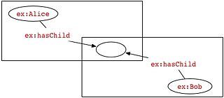
In RDF, a blank node is a node in an RDF graph representing a resource for which a URI or literal is not given. The resource represented by a blank node is also called an anonymous resource. According to the RDF standard a blank node can only be used as subject or object of an RDF triple.

<span class="mw-page-title-main">Linked data</span> Structured data and method for its publication

In computing, linked data is structured data which is interlinked with other data so it becomes more useful through semantic queries. It builds upon standard Web technologies such as HTTP, RDF and URIs, but rather than using them to serve web pages only for human readers, it extends them to share information in a way that can be read automatically by computers. Part of the vision of linked data is for the Internet to become a global database.

<span class="mw-page-title-main">GeoNames</span> Geographical database available and accessible through various web services

GeoNames is a user-editable geographical database available and accessible through various web services, under a Creative Commons attribution license. The project was founded in late 2005.

<span class="mw-page-title-main">DBpedia</span> Online database project

DBpedia is a project aiming to extract structured content from the information created in the Wikipedia project. This structured information is made available on the World Wide Web using OpenLink Virtuoso. DBpedia allows users to semantically query relationships and properties of Wikipedia resources, including links to other related datasets.

<span class="mw-page-title-main">Ontology engineering</span> Field that studies the methods and methodologies for building ontologies

In computer science, information science and systems engineering, ontology engineering is a field which studies the methods and methodologies for building ontologies, which encompasses a representation, formal naming and definition of the categories, properties and relations between the concepts, data and entities of a given domain of interest. In a broader sense, this field also includes a knowledge construction of the domain using formal ontology representations such as OWL/RDF. A large-scale representation of abstract concepts such as actions, time, physical objects and beliefs would be an example of ontological engineering. Ontology engineering is one of the areas of applied ontology, and can be seen as an application of philosophical ontology. Core ideas and objectives of ontology engineering are also central in conceptual modeling.

Knowledge extraction is the creation of knowledge from structured and unstructured sources. The resulting knowledge needs to be in a machine-readable and machine-interpretable format and must represent knowledge in a manner that facilitates inferencing. Although it is methodically similar to information extraction (NLP) and ETL, the main criterion is that the extraction result goes beyond the creation of structured information or the transformation into a relational schema. It requires either the reuse of existing formal knowledge or the generation of a schema based on the source data.

In natural language processing, linguistics, and neighboring fields, Linguistic Linked Open Data (LLOD) describes a method and an interdisciplinary community concerned with creating, sharing, and (re-)using language resources in accordance with Linked Data principles. The Linguistic Linked Open Data Cloud was conceived and is being maintained by the Open Linguistics Working Group (OWLG) of the Open Knowledge Foundation, but has been a point of focal activity for several W3C community groups, research projects, and infrastructure efforts since then.

References

  1. Official names of countries from FAO terminology database Archived 2009-04-25 at the Wayback Machine
  2. "FAO TERMINOLOGY". Archived from the original on 2009-02-19.
  3. Country or area code changes since 1982: United Nations Statistics Division - country or area codes added or changed
  4. "DCMI Metadata Terms" . Retrieved 2024-03-02.
  5. "OWL ontology". Archived from the original (XML) on 2015-04-13.
  6. 1 2 "FAO Geopolitical ontology (RDF)". Archived from the original on 2018-04-07.
  7. "Geopolitical ontology". Archived from the original on 2016-04-13.
  8. When an area (territory or group) changed but kept the same name, the ontology differentiates the two areas by sub-fixing the name of the obsolete one with the year (e.g. “FAO 2006”). The year indicates the beginning of validity of that particular area.
  9. The area type Other is used for Antarctica which has no government and belongs to no country. See also Politics in Antarctica.
  10. Special groups term is used for non-economical or greographical territory groups like the Small Island Developing States, Land Locked Countries, Low Income Food Deficit Countries, Least Developed Countries, etc.
  11. UN official names: Reports of the United Nations Conference on the Standardization of Geographical Names Archived 2009-01-30 at the Wayback Machine
  12. The value of the datatype property "validSince" is the first year of validity of a territory or group. The geopolitical ontology traces back historic changes only until 1985. Therefore if an area has a validSince = 1985, this indicates that the area is valid at least since 1985.
  13. The value of the datatype property "validUntil" is the last year of validity of the territory or group. In case the area is currently valid, this value is set by default to 9999.
  14. "Linked Data | Linked Data - Connect Distributed Data across the Web". Archived from the original on 2020-02-05. Retrieved 2011-07-08.
  15. Berners-Lee, Tim. "Linked Data" . Retrieved 2024-03-02.
  16. "The Linked Open Data Cloud" . Retrieved 2024-03-02.
  17. "Resource: Geopolitical ontology - Italy". Archived from the original on 2017-06-17.
  18. "Unknown".[ permanent dead link ]
  19. "FAO Geopolitical data". Archived from the original (XML) on 2018-03-29.
  20. "FAO geopolitical ontology". Archived from the original on 2012-03-24.
  21. Inventory of data sources used in the FAO country profiles Archived 2009-09-25 at the Wayback Machine
  22. Integrating country-based heterogeneous data at the United Nations: FAO's geopolitical ontology and services.