Georgia State Route 231

Last updated

Georgia 231.svg

State Route 231
Georgia state route 231 map.png
Route information
Maintained by GDOT
Length20.6 mi [1] (33.2 km)
Existed1940 [2] [3] –present
Major junctions
South endGeorgia 15.svg SR 15 southwest of Harrison
 
North endGeorgia 88.svgGeorgia 540.svg SR 88 / SR 540 north of Davisboro
Location
Counties Washington
Highway system
  • Georgia State Routes
Georgia 230.svg SR 230 SR 232 Georgia 232.svg

State Route 231 (SR 231) is a 20.6-mile-long (33.2 km) north-south state highway in the central part of the U.S. state of Georgia. It travels entirely within Washington County. It serves as a de facto bypass or alternate route for travelers who desired to bypass Sandersville.

Central Georgia is the area containing the metropolitan region surrounding the city of Macon, in Bibb County in the U.S. state of Georgia. It abuts the Atlanta metropolitan area, just to the north.

Georgia (U.S. state) State of the United States of America

Georgia is a state in the Southeastern United States. It began as a British colony in 1733, the last and southernmost of the original Thirteen Colonies to be established. Named after King George II of Great Britain, the Province of Georgia covered the area from South Carolina south to Spanish Florida and west to French Louisiana at the Mississippi River. Georgia was the fourth state to ratify the United States Constitution, on January 2, 1788. In 1802–1804, western Georgia was split to the Mississippi Territory, which later split to form Alabama with part of former West Florida in 1819. Georgia declared its secession from the Union on January 19, 1861, and was one of the original seven Confederate states. It was the last state to be restored to the Union, on July 15, 1870. Georgia is the 24th largest and the 8th most populous of the 50 United States. From 2007 to 2008, 14 of Georgia's counties ranked among the nation's 100 fastest-growing, second only to Texas. Georgia is known as the Peach State and the Empire State of the South. Atlanta, the state's capital and most populous city, has been named a global city. Atlanta's metropolitan area contains about 55% of the population of the entire state.

Washington County, Georgia County in the United States

Washington County is a county located in the U.S. state of Georgia. As of the 2010 census, the population was 21,187. The county seat is Sandersville. The county was established on February 25, 1784. It was named for Revolutionary War general George Washington.

Contents

Route description

SR 231 begins at an intersection with SR 15 southwest of Harrison. Here, the roadway continues as Harts Ford Road. The route travels northeast, passing through Harrison. It continues northeast and turns north, until it reaches the town of Riddleville. In Riddleville, it heads northeast, intersecting SR 242 (Bartow Road). The route heads north-northeast and turns northeast to Davisboro, where it intersects SR 24 just before leaving town. It heads north-northwest to meets its northern terminus, an intersection with SR 88, which is part of the Fall Line Freeway. Here, the roadway continues as Tree Nursery Road. [1]

Intersection (road) A road junction where two or more roads either meet or cross at grade

An intersection is an at-grade junction where two or more roads meet or cross. Intersections may be classified by number of road segments, traffic controls, and/or lane design.

Georgia State Route 15 highway in Georgia

State Route 15 (SR 15) is a 346-mile-long (557 km) state highway that travels south-to-north across the entire length of the U.S. state of Georgia, east of its centerline. It connects the Florida state line, south-southeast of Folkston with the North Carolina state line, in Dillard, via Folkston, Vidalia, Sandersville, Athens, Demorest, and Clayton.

Harrison, Georgia Town in Georgia, United States

Harrison is a town in Washington County, Georgia, United States. The population was 509 at the 2000 census.

SR 231 is not part of the National Highway System, a system of routes determined to be the most important for the nation's economy, mobility and defense. [4]

National Highway System (United States) highway system in the United States

The National Highway System (NHS) is a network of strategic highways within the United States, including the Interstate Highway System and other roads serving major airports, ports, rail or truck terminals, railway stations, pipeline terminals and other strategic transport facilities. Altogether, it constitutes the largest highway system in the world.

History

The roadway that would eventually become SR 231 was established in 1940 as SR 24 Spur along a short alignment from Downtown Davisboro to the intersection with SR 24 in the northern part of the city. [2] [3] In 1943, SR 24 Spur was redesignated as SR 231, and was extended to its current southern terminus. [5] [6] In 1944, the original section of the road was paved. [6] [7] In 1951, a short section southwest of Harrison was paved. [8] [9] By September 1953, the entire section from the southern terminus to Harrison was paved. [9] [10] The next year, a very brief section just northeast of Harrison was paved. [10] [11] By 1957, the entire section from Riddleville to SR 24 was paved, [12] [13] and by 1960, the road was paved from its southern terminus to SR 24. [13] [14] On the 1966 GDOT road map, the roadway that would eventually become the northern part of SR 231 from Davisboro to its northern terminus was displayed as a "connecting road". [15] [16] By 1991, this roadway was paved and designated as the northern extension of SR 231. [17] [18]

Major intersections

The entire route is in Washington County.

Locationmi [1] kmDestinationsNotes
0.00.0Georgia 15.svg SR 15  Wrightsville, Sandersville Southern terminus; roadway continues as Harts Ford Road.
Riddleville 10.216.4Georgia 242.svg SR 242 (Bartow Road) Sandersville, Bartow
Davisboro 17.227.7Georgia 24.svg SR 24  Sandersville, Louisville
20.633.2Georgia 88.svgGeorgia 540.svg SR 88 / SR 540 (Fall Line Freeway) Sandersville, Wrens, Augusta Northern terminus; roadway continues as Tree Nursery Road.
1.000 mi = 1.609 km; 1.000 km = 0.621 mi

See also

Related Research Articles

Interstate 985 (I-985) is a 25.01-mile-long (40.25 km) Auxiliary Interstate Highway in the northeastern part of the U.S. state of Georgia. It links the Atlanta metropolitan area to the city of Gainesville via Suwanee. I-985 is also known as the Sidney Lanier Parkway and is also designated as unsigned State Route 419. The roadway was designated as I-985 in 1985.

Georgia State Route 120 highway in Georgia

State Route 120 (SR 120) is a 90.7-mile-long (146.0 km) state highway that runs west-to-east through portions of Haralson, Paulding, Cobb, Fulton, and Gwinnett counties in northwestern part of the U.S. state of Georgia.

Georgia State Route 300 highway in Georgia

State Route 300, is a 107-mile-long (172 km) state highway in the southern part of the U.S. state of Georgia. Its southern terminus is at the Florida state line south-southeast of Thomasville, where the roadway continues as US 19/SR 57. This is also the southern terminus of SR 3, with which US 19 and SR 300 travel concurrently through the southern part of the state. Its northern terminus is at Interstate 75 (I-75) in Cordele.

Georgia State Route 365 highway in Georgia

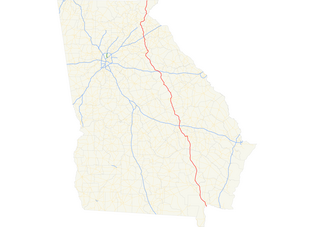
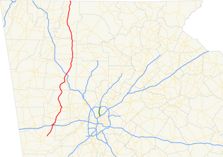
State Route 365 (SR 365) is a 69.5-mile-long (111.8 km) state highway that travels within portions of Gwinnett, Hall, Habersham, and Stephens counties. It begins at exit 113 on Interstate 85 (I-85), at the southeastern edge of Suwanee. This is also the southern terminus of I-985. It continues from that point concurrent with I-985 for the entire length of that freeway. Eventually, U.S. Route 23 (US 23) also joins the concurrency. The highway heads northeast through Gainesville and Toccoa, before it terminates at the South Carolina state line, southwest of Westminster, South Carolina.

Georgia State Route 332 highway in Georgia

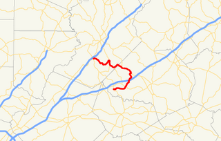
State Route 332 (SR 332) is a 23.2-mile (37.3 km) state highway in the northeastern part of the U.S. state of Georgia. It travels from SR 53 in Hoschton in Jackson County to SR 13 in Oakwood in Hall County. The route physically travels in a backwards "C" shape.

State Route 2 (SR 2) is a 165-mile-long (266 km) east-west state highway in the far northern part of the U.S. state of Georgia. The highway serves southern suburbs of Chattanooga, Tennessee, as well as much of the mountainous area in the northern part of the state. It traverses the counties of Walker, Catoosa, Whitfield, Murray, Gilmer, Fannin, Union, Towns, and Rabun. It connects Flintstone, in the northwestern part of the state, with the South Carolina state line southeast of Clayton in the northern part and the northeastern part of the state. It also travels through Fort Oglethorpe, Ringgold, Ellijay, Blue Ridge, Blairsville, and Hiawassee. Parts of the highway in the Whitfield and Murray county area are designated as the Cohutta–Chattahoochee Scenic Byway.

Georgia State Route 36 highway in Georgia

State Route 36 (SR 36) is a 95.2-mile-long (153.2 km) state highway that travels southwest-to-northeast through portions of Harris, Talbot, Upson, Lamar, Butts, and Newton counties in the central part of the U.S. state of Georgia. The highways connects the Waverly Hall area with Covington, via Thomaston, Barnesville, and Jackson.

U.S. Route 11 in Georgia

U.S. Route 11 (US 11) in the U.S. state of Georgia is a 22.8-mile-long (36.7 km) U.S. Highway the travels south-to-north through portions of Dade County in the northwestern part of the state. It is concurrent with State Route 58 (SR 58) for its entire length. In Georgia, the highway begins at US 11/SR 7 at the Alabama state line. It travels to its northern terminus at US 11/SR 38 at the Tennessee state line in Chattanooga, Tennessee.

Georgia State Route 273 highway in Georgia

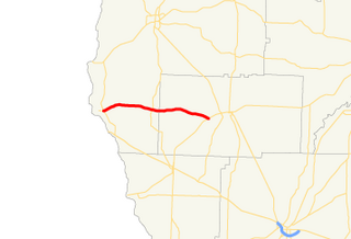
State Route 273 (SR 273) is a 17.2-mile-long (27.7 km) west-east state highway located in the southwestern part of the U.S. state of Georgia. It travels within Early and Miller counties.

Georgia State Route 270 highway in Georgia

State Route 270 (SR 270) is a 12.7-mile-long (20.4 km) east–west state highway located in the southern part of the U.S. state of Georgia. Its route is within Mitchell and Colquitt counties.

Georgia State Route 264 highway in Georgia

State Route 264 (SR 264) is a 2.7-mile-long (4.3 km) northwest-southeast state highway located in the eastern part of the Atlanta metropolitan area in the U.S. state of Georgia. Its route is entirely within Gwinnett County.

Georgia State Route 251 highway in Georgia

State Route 251 (SR 251) is a 13.5-mile-long (21.7 km) south–north state highway located in the east-central part of the U.S. state of Georgia. It travels entirely within McIntosh County.

Georgia State Route 242 highway in Georgia

State Route 242 (SR 242) is a 25.0-mile-long (40.2 km) east–west state highway located in the central part of the U.S. state of Georgia. It travels through portions of Washington and Jefferson counties.

Georgia State Route 241 highway in Georgia

State Route 241 (SR 241) is a 5.6-mile-long (9.0 km) southwest-northeast state highway located in the southwestern part of the U.S. state of Georgia. It exists entirely within Decatur County.

Georgia State Route 61 highway in Georgia

State Route 61 (SR 61) is a 107.1-mile-long (172.4 km) state highway that travels south-to-north through portions of Carroll, Douglas, Paulding, Bartow, Gordon, and Murray counties in the western and northwestern parts of the U.S. state of Georgia. The highway connects the Carrollton area with the Tennessee state line, via Villa Rica, Dallas, Cartersville, and Chatsworth. The portion of the highway from just northeast of Carrollton to Villa Rica was formerly the path of US 78S. When that highway was decommissioned, it was redesignated as US 78 Alternate.

U.S. Route 76 in Georgia highway in Georgia, United States

U.S. Route 76 (US 76) is an 150.7-mile-long (242.5 km) east–west U.S. highway in the U.S. state of Georgia. It begins at the Tennessee state line, east of Lakeview, Georgia, where the roadway continues concurrent with US-41/SR-8 toward Chattanooga. It ends at the South Carolina state line, where US 76 continues toward Anderson. In Georgia, the highway travels within portions of Catoosa, Whitfield, Murray, Gilmer, Fannin, Union, Towns, and Rabun counties. It travels through North Georgia and connects Ringgold, Dalton, Chatsworth, Ellijay, Blue Ridge, Blairsville, and Clayton. Most of the highway is part of the Lookout Mountain Scenic Highway, a highway that travels through northern Georgia and through the Chattahoochee-Oconee National Forest.

Georgia State Route 223 highway in Georgia

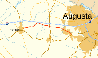
State Route 223 (SR 223) is a 20.9-mile-long (33.6 km) east–west state highway in the east-central part of the U.S. state of Georgia. Its routing travels through portions of McDuffie, Columbia, and Richmond counties. The highway connects Thomson with Grovetown, Augusta, and Fort Gordon. Except for the portions in Thomson, Grovetown, and Augusta, the highway is relatively rural.

Georgia State Route 103 highway in Georgia

State Route 103 (SR 103) is a 13.9-mile-long (22.4 km) state highway in the west-central part of the U.S. state of Georgia. The highway travels from a point northwest of Mulberry Grove northwest to West Point. The highway used to travel through Muscogee, Chattahoochee, and Marion counties, but was truncated through Fort Benning. Its former path was redesignated as parts of SR 137 Spur, SR 357 and SR 219.

Georgia State Route 227 highway in Georgia

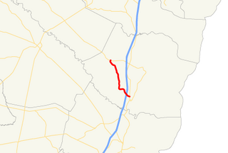
State Route 227 (SR 227) is a 2.2-mile-long (3.5 km) connecting state highway that travels south-to-north through portions of Treutlen County in the east-central part of the U.S. state of Georgia.

Georgia State Route 228 highway in Georgia

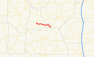
State Route 228 (SR 228) is a 10.2-mile (16.4 km) state highway that travels west-to-east in the western part of the U.S. state of Georgia. Its travels through portions of Schley and Sumter counties.

References

  1. 1 2 3 Google (March 8, 2013). "Overview map of SR 231" (Map). Google Maps . Google. Retrieved March 8, 2013.
  2. 1 2 State Highway Department of Georgia (October 1, 1940). System of State Roads (PDF) (Map). Scale not given. Atlanta: State Highway Department of Georgia. OCLC   5673161 . Retrieved March 8, 2013.
  3. 1 2 State Highway Department of Georgia (January 1, 1941). System of State Roads (PDF) (Map). Scale not given. Atlanta: State Highway Department of Georgia. OCLC   5673161 . Retrieved March 8, 2013.
  4. "National Highway System: Georgia" (PDF). United States Department of Transportation. May 8, 2009. Retrieved March 8, 2013.
  5. State Highway Department of Georgia (January 1, 1943). System of State Roads (PDF) (Map). Scale not given. Atlanta: State Highway Department of Georgia. OCLC   5673161 . Retrieved March 8, 2013.
  6. 1 2 State Highway Department of Georgia (January 1, 1944). System of State Roads (PDF) (Map). Scale not given. Atlanta: State Highway Department of Georgia. OCLC   5673161 . Retrieved March 8, 2013.
  7. State Highway Department of Georgia (January 1, 1945). System of State Roads (PDF) (Map). Scale not given. Atlanta: State Highway Department of Georgia. OCLC   5673161 . Retrieved March 8, 2013.
  8. State Highway Department of Georgia (1950). System of State Roads (PDF) (Map). Scale not given. Atlanta: State Highway Department of Georgia. OCLC   5673161 . Retrieved March 8, 2013. (Corrected to August 1, 1950.)
  9. 1 2 State Highway Department of Georgia (1952). System of State Roads (PDF) (Map). Scale not given. Atlanta: State Highway Department of Georgia. OCLC   5673161 . Retrieved March 8, 2013. (Corrected to January 1, 1952.)
  10. 1 2 State Highway Department of Georgia (1953). State Highway System and Other Principal Connecting Roads (PDF) (Map). Scale not given. Atlanta: State Highway Department of Georgia. OCLC   5673161 . Retrieved March 8, 2013. (Corrected to September 1, 1953.)
  11. State Highway Department of Georgia (1954). State Highway System and Other Principal Connecting Roads (PDF) (Map). Scale not given. Atlanta: State Highway Department of Georgia. OCLC   5673161 . Retrieved March 8, 2013. (Corrected to June 1, 1954.)
  12. State Highway Department of Georgia (1955). State Highway System and Other Principal Connecting Roads (PDF) (Map). Scale not given. Atlanta: State Highway Department of Georgia. OCLC   5673161 . Retrieved March 8, 2013. (Corrected to June 1, 1955.)
  13. 1 2 State Highway Department of Georgia (1957). State Highway System and Other Principal Connecting Roads (PDF) (Map). Scale not given. Atlanta: State Highway Department of Georgia. OCLC   5673161 . Retrieved March 8, 2013. (Corrected to July 1, 1957.)
  14. State Highway Department of Georgia (1960). State Highway System and Other Principal Connecting Roads (PDF) (Map) (1960–1961 ed.). Scale not given. Atlanta: State Highway Department of Georgia. OCLC   5673161 . Retrieved March 8, 2013. (Corrected to June 1, 1960.)
  15. State Highway Department of Georgia (1963). State Highway System and Other Principal Connecting Roads (PDF) (Map). Scale not given. Atlanta: State Highway Department of Georgia. OCLC   5673161 . Retrieved March 8, 2013. (Corrected to June 1, 1963.)
  16. State Highway Department of Georgia (January 1966). Official Highway Map (PDF) (Map). Scale not given. Atlanta: State Highway Department of Georgia. Retrieved March 8, 2013.
  17. Georgia Department of Transportation (1990). Official Highway and Transportation Map (PDF) (Map) (1990–1991 ed.). Scale not given. Atlanta: Georgia Department of Transportation. Retrieved March 8, 2013.
  18. Georgia Department of Transportation (1991). Official Highway and Transportation Map (PDF) (Map) (1991–1992 ed.). Scale not given. Atlanta: Georgia Department of Transportation. Retrieved March 8, 2013.
KML file (edithelp)
    KML is not from Wikidata