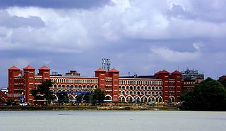
Howrah is a city in the Indian state of West Bengal. Howrah is located on the western bank of the Hooghly River, opposite its twin city of Kolkata. Administratively Howrah lies within Howrah district and is the headquarters of the Howrah Sadar subdivision; it is also part of the area covered by Kolkata Metropolitan Development Authority (KMDA). Howrah is an important industrial and transportation hub, and is also a gateway to Kolkata via Howrah railway station and Howrah Bridge.

Belur is a neighbourhood in Howrah of Howrah district in the Indian state of West Bengal. It is a part of the area covered by Kolkata Metropolitan Development Authority (KMDA). Belur is under the jurisdiction of Belur Police Station and Bally Police Station of Howrah City Police. The area is best known for Belur Math, a religious monastery containing a complex of temples. Belur Math is famous for being the headquarters of the Ramakrishna Math, a monastic order, as well as that of the related Ramakrishna Mission, both founded by Swami Vivekananda. On the opposite side of the Hooghly River, opposite to Belur Math is the Dakshineswar Kali Temple.

Uttarpara or Uttarpara Kotrung is a city and a municipality of Hooghly district in the Indian state of West Bengal. It is a part of the area covered by Kolkata Metropolitan Development Authority (KMDA). Uttarpara is located at 22.67°N 88.35°E, within 10 km from Kolkata, the capital of the state of West Bengal. It is located along the Hooghly river, across from the Dakshineswar Kali Temple. Uttarpara is home to the Uttarpara Jayakrishna Public Library, Asia's oldest free public library.

Chamrail is a census town in Bally Jagachha CD Block of Howrah Sadar subdivision in Howrah district in the Indian state of West Bengal.

Jagadishpur is a census town in Bally Jagachha CD Block of Howrah Sadar subdivision in Howrah district in the Indian state of West Bengal.
Khalia is a census town in Bally Jagachha CD Block of Howrah Sadar subdivision in Howrah district in the Indian state of West Bengal. Khalia is under the jurisdiction of Liluah Police Station of Howrah City Police.

Belgharia is a neighbourhood in Kamarhati of North 24 Parganas district in the Indian state of West Bengal. It is a part of the area covered by Kolkata Metropolitan Development Authority (KMDA).

Bally is a neighbourhood in Howrah of Howrah district in the Indian state of West Bengal. Bally is under the jurisdiction of Bally Police Station of Howrah City Police. It is a part of the area covered by Kolkata Metropolitan Development Authority (KMDA).
Bhattanagar is a neighbourhood in Howrah of Howrah district in the Indian state of West Bengal. It is a part of the area covered by Kolkata Metropolitan Development Authority (KMDA). Bhattanagar is under the jurisdiction of Liluah police station of Howrah City Police.

Kadamtala is a neighbourhood in Howrah of Howrah district in the Indian state of West Bengal. It is a part of the area covered by Kolkata Metropolitan Development Authority (KMDA). Kadamtala is under the jurisdiction of Bantra Police Station of Howrah City Police.
Bally is a census town in Bally Jagachha CD Block of Howrah Sadar subdivision in Howrah district in the Indian state of West Bengal. Bally is under the jurisdiction of Nischinda Police Station of Howrah City Police.

Liluah is a neighbourhood in Howrah of Howrah district in the Indian state of West Bengal. It is a part of the area covered by Kolkata Metropolitan Development Authority (KMDA). Liluah has a railway junction, which is the first station after Howrah station under the Eastern Railway (India). Its history dates back to the British era when the Liluah Carriage and wagon Workshop was set up to release pressure off Howrah.

Ramrajatala is a neighbourhood in Howrah of Howrah district in the Indian state of West Bengal. It is a part of the area covered by Kolkata Metropolitan Development Authority (KMDA). Ramrajatala is under the jurisdiction of Chatterjeehat Police Station, Dasnagar Police Station and Jagacha Police Station of Howrah City Police.
Pilkhana is a neighbourhood in Howrah of Howrah district in the Indian state of West Bengal. Pilkhana is governed by Golabari Police Station under Howrah City Police. It is a part of the area covered by Kolkata Metropolitan Development Authority (KMDA).
Salkia is a neighbourhood in Howrah of Howrah district in the Indian state of West Bengal. Salkia is under the jurisdiction of Golabari Police Station and Malipanchghara Police Station of Howrah City Police. It is a part of the area covered by Kolkata Metropolitan Development Authority (KMDA).

The Howrah–Barddhaman main line is a broad-gauge railway line connecting Howrah and Barddhaman via Bandel. The 107 kilometres (66 mi) railway line operates in Howrah, Hooghly and Purba Barddhaman districts in the Indian state of West Bengal. It is part of the Howrah–Delhi main line and the Kolkata Suburban Railway system.
Howrah City Police established in 2011, is a city police force with primary responsibilities in law enforcement and investigation in Howrah city and some of its adjacent areas in Howrah district. The Commissionerate is part of the West Bengal Police and is under the administrative control of Home Ministry of West Bengal. It was formed after the bifurcation of the Howrah Police District and has eighteen police stations under its jurisdiction as of now. Presently, P. K. Tripathi, IPS is appointed as the Commissioner of the Howrah Police Commissionerate.
Nandy Bagan or Nandi Bagan is a neighbourhood of South Kolkata in the Indian state of West Bengal. It is a residential area surrounded with Kasba, Haltu, Garfa, Jadavpur, Babu Bagan, Dhakuria, Naskarpara, Shahid Nagar, Bosepukur and Selimpur. It is traditionally an upper-middle-class neighbourhood, situated around the Nandi Bagan community playground. However, with the newly constructed Prince Anwar Shah Road connector with the Eastern Metropolitan Bypass, property prices have increased in the area. The area is covered by the Garfa Police Station of the Kolkata Police Force. The Haltu Post Office serves the area.

Dum Dum Park is a neighbourhood in South Dumdum of North 24 Parganas district in the Indian state of West Bengal. It is a part of the area covered by Kolkata Metropolitan Development Authority (KMDA).

Bhot Bagan Moth popularly known as Mahakal Math is a Tibetan Buddhist Temple located at Ghusuri, Howrah district in the Indian state of West Bengal. It is the first Tibetan Buddhist Temple in the plains of India. The Moth is a unique monastery with rare combination of Shaiva and Tibetan Buddhist culture.


