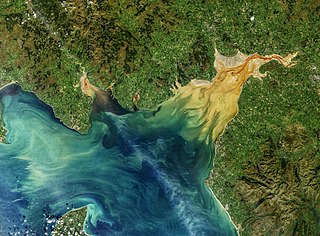
The Solway Firth is an inlet on the west coast of Great Britain, forming part of the border between England and Scotland. The "firth" divides Cumbria from Dumfries and Galloway. It stretches from St Bees Head, just south of Whitehaven in Cumbria, to the Mull of Galloway, on the western end of Dumfries and Galloway. The Isle of Man is also very near to the firth. The firth comprises part of the Irish Sea.

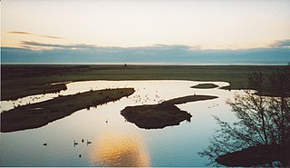
WWT Caerlaverock is wetland nature reserve in southwest Scotland, one of ten reserves in Britain operated by the Wildfowl and Wetlands Trust founded by Sir Peter Scott.

Caerlaverock is a civil parish in Dumfries and Galloway, Scotland.

Caerlaverock is a national nature reserve (NNR) covering parts of the mudflats and shoreline of the Solway Firth about 10 km south of Dumfries, in Dumfries and Galloway, Scotland. It lies between the River Nith and the Lochar Water, and consists of a variety of wetland habitats including bare mud and sand, merse and marshes, and is fringed by neutral grassland on the landward side. A nature reserve was designated in 1957 at the instigation of the Duke of Norfolk. The NNR covers an area of 82 square kilometres (32 sq mi) and is an internationally important wintering site for waterfowl and wading birds.

Dumfries is a market town and former royal burgh in Dumfries and Galloway, Scotland, near the mouth of the River Nith on the Solway Firth, 25 miles (40 km) from the Anglo-Scottish border. Dumfries is the county town of the historic county of Dumfriesshire.

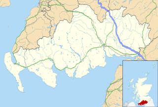
Dumfries and Galloway is one of the 32 unitary council areas of Scotland, located in the western part of the Southern Uplands. It is bordered by East Ayrshire, South Ayrshire, and South Lanarkshire to the north; Scottish Borders to the north-east; the English county of Cumbria, the Solway Firth, and the Irish Sea to the south, and the North Channel to the west. The administrative centre and largest settlement is the town of Dumfries. The second largest town is Stranraer, located 76 miles (122 km) to the west of Dumfries on the North Channel coast.

Kirkcudbrightshire or the County of Kirkcudbright or the Stewartry of Kirkcudbright is one of the historic counties of Scotland, covering an area in the south-west of the country. Until 1975, Kirkcudbrightshire was an administrative county used for local government. Since 1975, the area has formed part of Dumfries and Galloway for local government purposes. Kirkcudbrightshire continues to be used as a registration county for land registration. A lower-tier district called Stewartry covered the majority of the historic county from 1975 to 1996. The area of Stewartry district is still used as a lieutenancy area. Dumfries and Galloway Council also has a Stewartry area committee.

Dumfriesshire or the County of Dumfries or Shire of Dumfries is a historic county and registration county in southern Scotland. The Dumfries lieutenancy area covers a similar area to the historic county.

The River Nith is a river in south-west Scotland. The Nith rises in the Carsphairn hills of East Ayrshire, between Prickeny Hill and Enoch Hill, 4.4 miles (7.1 km) east of Dalmellington. For the majority of its 70 miles (110 km) course it flows in a south-easterly direction through Dumfries and Galloway and then into the Solway Firth at Airds Point.

Haugh of Urr, is a village in the historical county of Kirkcudbrightshire in Dumfries and Galloway, Scotland. It is approximately 4 miles NNW of Dalbeattie, 3 mi (5 km) NE of Castle Douglas, 12+1⁄2 mi (20 km) west of Dumfries and 12+1⁄2 mi (20 km) east of Kirkcudbright.

Kirkbean is a Scottish village and civil parish on the Solway Firth, in the historic county of Kirkcudbrightshire and council area of Dumfries and Galloway. In the 2001 census, the four small villages making up the parish of Kirkbean had a total population of 643. It includes the hamlet of Loaningfoot.

Brow is a hamlet on the B725 lying around 3 km from Ruthwell in the Parish of that name on the Solway Firth between Dumfries and Annan in Dumfries and Galloway, Scotland. The Raffles Burn runs through the site, marked on maps as the Brow Burn it flows into the Solway Firth at Lochar Bay.

Wigtown Harbour or Wigtown Quay was relocated in 1818 to serve the town of Wigtown and its hinterland in Wigtownshire, Dumfries and Galloway, following the silting up of the original natural harbour that was originally located near to St Machute's church. This relocation occurred following centuries of silting and then the alteration of the course of the River Bladnoch that runs into Wigtown Bay where it joins the River Cree.

Bankend is a village in Dumfries and Galloway, Scotland. It is located near Lochar Water, the civil parish Caerlaverock and the villages of Blackshaw, Glencaple and Shearington. In 1961 it had a population of 79.

Lochar Water is a stream located in Dumfries and Galloway. It flows for about 10 miles or 16 km, mainly in a southerly direction, roughly parallel to the River Nith to the west and the River Annan to the east. It is formed by the confluence of Park Burn and Amisfield Burn, and skirts the eastern side of the town of Dumfries, and flows through an extensive low-lying area and former raised peat land known as Lochar Moss, before flowing into the Solway Firth. Bankend Bridge, part of the B725 road, crosses Lochar Water on the east side of Bankend village. The tidal limit is about 1 km below that. It shares its name with an electoral ward of the Dumfries and Galloway council

Kingholm Quay, commonly called the New Quay (NX975735) in the 19th century and its associated village and warehouses is located on the River Nith, once serving the town of Dumfries and its hinterland in Dumfries and Galloway. The port of Dumfries lay upstream and downstream quays or harbours were located at Laghall, Kelton, Glencaple, Carsethorn and Kirkconnell Jetty. It is not clear whether Kingholm was home to a fishing fleet of any sort. Mavisgrove Merse lay opposite.

Laghall Quay (NX973732) is located on the River Nith, once serving the estate of Laghall, later named Mavis Grove and now again called Laghall as well as its hinterland in Dumfries and Galloway, previously Kirkcudbrightshire. The ports of Dumfries, Kingholm Quay and Castledykes Quay lay upstream and downstream quays or harbours were located at Kelton, Glencaple, Carsethorn and Kirkconnell Jetty. It lies on the edge of the old Mavisgrove Merse.

Glencaple Quay (NX994687) is located on the River Nith, it mainly served the town of Dumfries and to some degree the Glencaple area as well as its hinterland in Dumfries and Galloway. The quays at Dumfries, Kingholm Quay Laghall, Kelton and Castledykes lay upstream and downstream jetties were located at Kirkconnell and Carsethorn. It lies opposite Kirkconnell Merse.

Kelton Harbour and Village (NX988708) are located on the East side of the River Nith opposite the Kirkconnell Merse, about 3.5 miles (5.6Km) from Dumfries and 1.5 miles (2.4Km) north of Glencaple Quay. The old harbour served the immediate area as well as its hinterland in Dumfries and Galloway. The quays at Dumfries, Kingholm Quay Laghall and Castledykes lay upstream and downstream jetties or quays were located at Glencaple Quay, Kirkconnell and Carsethorn.


