
Washington County is a county in the U.S. state of Indiana. As of the 2020 United States Census, the population was 28,182. The county seat is Salem.

Tippecanoe County is located in the west-central portion of the U.S. state of Indiana about 22 miles east of the Illinois state line and less than 50 miles from the Chicago and the Indianapolis metro areas. As of the 2020 census, the population was 186,251. The county seat and largest city is Lafayette. It was created in 1826 from Wabash County portion of New Purchase and unorganized territory.

Pulaski County is a county located in the U.S. state of Indiana. According to the 2020 U.S. census, the population was 12,514. The county seat is Winamac.

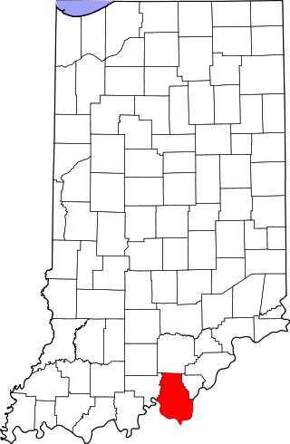
Harrison County is located in the far southern part of the U.S. state of Indiana along the Ohio River. The county was officially established in 1808. Its population was 39,654 as of the 2020 United States Census. Its county seat is Corydon, the former capital of Indiana.

Blackford County is located in the east central portion of the U.S. state of Indiana. The county is named for Judge Isaac Blackford, who was the first speaker of the Indiana General Assembly and a long-time chief justice of the Indiana Supreme Court. Created in 1838, Blackford County is divided into four townships, and its county seat is Hartford City. Two incorporated cities and one incorporated town are located within the county. The county is also the site of numerous unincorporated communities and ghost towns. Occupying only 165.58 square miles (428.9 km2), Blackford County is the fourth smallest county in Indiana. As of the 2020 census, the county's population was 12,112. Based on population, the county is the 8th smallest county of the 92 in Indiana. Although no interstate highways are located in Blackford County, three Indiana state roads cross the county, and an additional state road is located along the county's southeast border. The county has two railroad lines. A north–south route crosses the county, and intersects with a second railroad line that connects Hartford City with communities to the west.

The Battle of Corydon was a minor engagement that took place July 9, 1863, just south of Corydon, which had been the original capital of Indiana until 1825, and was the county seat of Harrison County. The attack occurred during Morgan's Raid in the American Civil War as a force of 2,500 cavalry invaded the North in support of the Tullahoma Campaign. It was the only pitched battle of the Civil War that occurred in Indiana, and no battle has occurred within Indiana since.
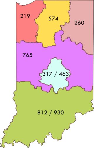
Area codes 812 and 930 are telephone area codes in the North American Numbering Plan (NANP) for the southern third of the state of Indiana.

State Road 11 in the U.S. state of Indiana is located in south central Indiana and is divided into a northern and southern section. These sections were never connected.
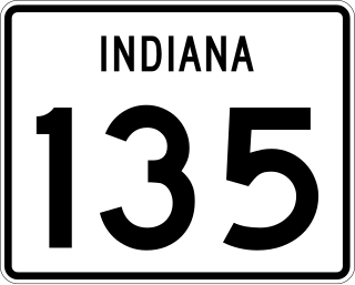
State Road 135 (SR 135) in the U.S. State of Indiana is a road that connects Indianapolis with the Ohio River; for the most part it is a two-lane road except for near Greenwood and Indianapolis.

Strother Madison Stockslager was an American lawyer, Civil War veteran, and politician who served two terms as a U.S. Representative from Indiana from 1881 to 1885.
Heth Township is one of twelve townships in Harrison County, Indiana, United States. As of the 2010 census, its population was 1,278 and it contained 573 housing units.

Cross Roads is an unincorporated community in Salem Township, Delaware County, Indiana.
Bradford is an unincorporated community in Morgan Township, Harrison County, Indiana.
Central is an unincorporated community in Heth Township, Harrison County, Indiana.

Dogwood is an unincorporated community in Webster Township, Harrison County, Indiana.
Frenchtown is an unincorporated community in Spencer Township, Harrison County, Indiana.

Valley City is an unincorporated community in Washington Township, Harrison County, Indiana.
Davidson is an unincorporated community in Boone township in Harrison County, Indiana, in the United States. Davidson had a post office between 1839 and 1924. The community was likely named for its first postmaster, David Aistin.
Paul and Susannah Mitchem were a couple from Virginia who owned dozens of slaves; late in their life they decided to bring their slaves to Harrison County, Indiana and free them. They also used the Meachum surname. The Mitchems emancipated over 100 enslaved people in Indiana, most of whom settled around Corydon, Indiana. Farms, businesses, churches, and schools were established by and for the African American community, often called the Mitchem Settlement.


