Laconia, Indiana

Last updated

Town of Laconia, Indiana
Laconia General Store.jpg
The Laconia General Store, located at the heart of the community
Harrison County Indiana Incorporated and Unincorporated areas Laconia Highlighted 1840644.svg
Location of Laconia in Harrison County, Indiana.
Coordinates: 38°1′56″N86°5′7″W / 38.03222°N 86.08528°W / 38.03222; -86.08528
Country United States
State Indiana
County Harrison
Township Boone
Area
[1]
  Total0.05 sq mi (0.13 km2)
  Land0.05 sq mi (0.13 km2)
  Water0.00 sq mi (0.00 km2)
Elevation
[2]
663 ft (202 m)
Population
 (2020)
  Total73
  Density1,431.37/sq mi (557.84/km2)
Time zone UTC-5 (EST)
  Summer (DST) UTC-4 (EDT)
ZIP code
47135
Area code 812
FIPS code 18-40644 [3]
GNIS feature ID2396701 [2]

Laconia is a town in Boone Township, Harrison County, Indiana, United States. The population was 50 at the 2010 census.

Contents

Geography

Laconia is located at 38°1′56″N86°5′7″W / 38.03222°N 86.08528°W / 38.03222; -86.08528 (38.032174, -86.085271). [4]

According to the 2010 census, Laconia has a total area of 0.05 square miles (0.13 km2), all land. [5]

History

Laconia is a small farming community and was platted in 1816 by John Boone. [6] The Boone family, prominent in the settlement of southern Harrison County, owned large tracts of land throughout the township which bears their name. The original town, consisting of 64 lots, was laid out on property of four owners: William Smith, William Winigar, William Williams, and William Madden Sr.

Because Laconia was the only town of any size in Boone Township, the settlement became the commercial center of the area. Laconia was the distribution center for mail and was served by the L&N Railroad, which ran on the Kentucky side of the Ohio River.

Because of the proximity of an ample supply of lumber, the Elbert Brothers established a furniture factory near Laconia in 1868. The business burned in 1880 and was never rebuilt. Just south of town, John Ashton had a lumber mill which provided materials for many of Laconia's structures.

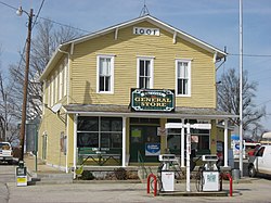
Laconia at one time boasted three general stores, one on each corner of the town square, three hotels, several millinery stores, two doctors, a funeral parlor, and a saloon. The Laconia General Store, built in 1927, is the only remaining commercial building operating on the square.

Laconia is the home of an Odd Fellows Club first organized on May 20, 1875.

Two churches were established in Laconia. The Laconia Presbyterian Church was organized in 1874 and met in the town hall and private homes until 1880, when the present church was built on Cross St. The Laconia Methodist Church was organized in 1842, and closed in 2017. The minister traveled from Mauckport, about seven miles to the southwest, to conduct services. The present church was built in 1874 on Main St.

In March 1932, fire destroyed the frame two-story school known as Clay Hill College, and a new school was built of brick in 1932–1933 by the Works Progress Administration (WPA). Upon consolidation of the Harrison County Schools, the building was vacated in 1985. The late Bill Cook restored the structure and it now serves as a community center and apartments.

Another notable building in Laconia is on Main St, the Hurst House built in the Greek Revival style by Dr. Hurst in 1869. [7]

Demographics

Historical population
CensusPop.Note
1880 112
1890 13318.8%
1900 1351.5%
1910 82−39.3%
1920 831.2%
1930 10324.1%
1940 83−19.4%
1950 82−1.2%
1960 75−8.5%
1970 64−14.7%
1980 58−9.4%
1990 7529.3%
2000 29−61.3%
2010 5072.4%
2020 7346.0%
U.S. Decennial Census [8]

2010 census

As of the census [9] of 2010, there were 50 people, 21 households, and 15 families living in the town. The population density was 1,000.0 inhabitants per square mile (386.1/km2). There were 25 housing units at an average density of 500.0 per square mile (193.1/km2). The racial makeup of the town was 98.0% White and 2.0% Asian.

There were 21 households, of which 23.8% had children under the age of 18 living with them, 61.9% were married couples living together, 9.5% had a female householder with no husband present, and 28.6% were non-families. 19.0% of all households were made up of individuals, and 4.8% had someone living alone who was 65 years of age or older. The average household size was 2.38 and the average family size was 2.73.

The median age in the town was 41 years. 16% of residents were under the age of 18; 16% were between the ages of 18 and 24; 22% were from 25 to 44; 40% were from 45 to 64; and 6% were 65 years of age or older. The gender makeup of the town was 48.0% male and 52.0% female.

2000 census

As of the census [3] of 2000, there were 29 people, 14 households, and 6 families living in the town. The population density was 583.2 inhabitants per square mile (225.2/km2). There were 18 housing units at an average density of 362.0 per square mile (139.8/km2). The racial makeup of the town was 100.00% White.

There were 14 households, out of which 21.4% had children under the age of 18 living with them, 28.6% were married couples living together, 14.3% had a female householder with no husband present, and 57.1% were non-families. 57.1% of all households were made up of individuals, and 35.7% had someone living alone who was 65 years of age or older. The average household size was 2.07 and the average family size was 3.50.

In the town, the population was spread out, with 27.6% under the age of 18, 3.4% from 18 to 24, 24.1% from 25 to 44, 27.6% from 45 to 64, and 17.2% who were 65 years of age or older. The median age was 40 years. For every 100 females, there were 45.0 males. For every 100 females age 18 and over, there were 40.0 males.

The median income for a household in the town was $16,667, and the median income for a family was $17,083. Males had a median income of $23,750 versus $16,250 for females. The per capita income for the town was $9,779. There were 60.0% of families and 50.0% of the population living below the poverty line, including 81.8% of under eighteens and none of those over 64.

Notable people

Related Research Articles

<span class="mw-page-title-main">Jamestown, Indiana</span> Town in Indiana, United States

Jamestown is a town in Jackson Township, Boone County and Eel River Township, Hendricks County, Indiana, United States. The population was 958 at the 2010 census.

<span class="mw-page-title-main">Thorntown, Indiana</span> Town in Indiana, United States

Thorntown is a town in Sugar Creek Township, Boone County, Indiana. The population was 1,520 at the time of the 2010 census. Thorntown is located in northwestern Boone County, about halfway between Lafayette and Indianapolis.

<span class="mw-page-title-main">Ulen, Indiana</span> Town in Indiana, United States

Ulen is a town in Center Township, Boone County, in the U.S. state of Indiana. The population was 117 at the 2010 census. The town is surrounded by the city of Lebanon.

<span class="mw-page-title-main">Royal Center, Indiana</span> Town in Indiana, United States

Royal Center is a town in Boone Township, Cass County, Indiana, United States. The population was 861 at the 2010 census.

<span class="mw-page-title-main">Alton, Indiana</span> Town in Indiana, United States

Alton is a town in Boone Township, Crawford County, Indiana, United States. The population was 29 at the 2020 census.

<span class="mw-page-title-main">West Harrison, Indiana</span> Town in Indiana, United States

West Harrison is a town in Harrison Township, Dearborn County, Indiana, United States. The population was 289 at the 2010 census.

<span class="mw-page-title-main">Albany, Indiana</span> Town in Indiana, United States

Albany is a town in Delaware and Randolph counties in the U.S. state of Indiana, along the Mississinewa River. The population was 2,295 at the 2020 census. It is part of the Muncie, IN Metropolitan Statistical Area.

<span class="mw-page-title-main">Gaston, Indiana</span> Town in Indiana, United States

Gaston is a town in Washington Township, Delaware County, Indiana, United States. The population was 796 at the 2020 census. It is part of the Muncie Metropolitan Statistical Area.

<span class="mw-page-title-main">Elizabeth, Indiana</span> Town in Indiana, United States

Elizabeth is a town in Posey Township, Harrison County, Indiana, United States. The population was 162 at the 2010 census.

<span class="mw-page-title-main">Mauckport, Indiana</span> Town in Indiana, United States

Mauckport is a town in Heth Township, Harrison County, Indiana, along the Ohio River. The population was 81 at the 2010 census.

<span class="mw-page-title-main">New Middletown, Indiana</span> Town in Indiana, United States

New Middletown is a town in Webster Township, Harrison County, Indiana, United States. The population was 93 at the 2010 census.

<span class="mw-page-title-main">Palmyra, Indiana</span> Town in Indiana, United States

Palmyra is a town in Morgan Township, Harrison County, Indiana, United States. The population was 930 at the 2010 census.

<span class="mw-page-title-main">Woodlawn Heights, Indiana</span> Town in Indiana, United States

Woodlawn Heights is a town in Anderson Township, Madison County, Indiana, United States. It is part of the Indianapolis–Carmel–Anderson metropolitan statistical area. The population was 91 at the 2020 census.

<span class="mw-page-title-main">Battle Ground, Indiana</span> Town in Indiana, US

Battle Ground is a town in Tippecanoe Township, Tippecanoe County in the U.S. state of Indiana. The population was 1,334 at the 2010 census. It is near the site of the Battle of Tippecanoe.

<span class="mw-page-title-main">Hardinsburg, Indiana</span> Census-designated place in Indiana, United States

Hardinsburg is a census-designated place in Posey Township, Washington County, in the U.S. state of Indiana. The population was 222 at the 2020 census.

<span class="mw-page-title-main">Farnham, New York</span> Village in New York, United States

Farnham is a village in the town of Brant, Erie County, New York, United States. The population of Farnham was 381 at the 2020 census. It is part of the Buffalo–Niagara Falls Metropolitan Statistical Area. The village is named after Leroy Farnham, a local landowner and merchant.

<span class="mw-page-title-main">Carl's Corner, Texas</span> Town in Texas, United States

Carl's Corner is a town in Hill County, Texas, United States. The population was 173 at the 2010 census. The town was founded by, and named after, Carl Cornelius, a local truck stop owner and long-time friend of Willie Nelson. Cornelius founded the town for the purpose of legalizing alcohol sales in the otherwise mostly-dry county.

<span class="mw-page-title-main">Madison, West Virginia</span> City in West Virginia, United States

Madison is a city and former coal town in Boone County, West Virginia, United States. The population was 2,911 at the 2020 census. It is the county seat of Boone County.

<span class="mw-page-title-main">Sylvester, West Virginia</span> Town in West Virginia, United States

Sylvester is a town in Boone County, West Virginia, United States, along the Big Coal River. The population was 166 at the 2020 census. Sylvester was incorporated on April 11, 1952 by the Boone County Circuit Court. Sylvester bears the name of a family of settlers.

<span class="mw-page-title-main">Whitesville, West Virginia</span> Town in West Virginia, United States

Whitesville is a town and former coal town in Boone County, West Virginia, United States, along the Big Coal River. The population was 361 at the 2020 census. Whitesville was incorporated on August 15, 1935 by the Boone County Circuit Court. The town derives its name from B. W. White, a pioneer settler. Whitesville was formerly known as Jarrold's Valley and Pritchard City.

References

  1. "2020 U.S. Gazetteer Files". United States Census Bureau. Retrieved March 16, 2022.
  2. 1 2 U.S. Geological Survey Geographic Names Information System: Laconia, Indiana
  3. 1 2 "U.S. Census website". United States Census Bureau . Retrieved January 31, 2008.
  4. "US Gazetteer files: 2010, 2000, and 1990". United States Census Bureau. February 12, 2011. Retrieved April 23, 2011.
  5. "G001 - Geographic Identifiers - 2010 Census Summary File 1". United States Census Bureau. Archived from the original on February 13, 2020. Retrieved July 17, 2015.
  6. Roose, William H. (1911). Indiana's Birthplace: A History of Harrison County, Indiana. Tribune Company, Printers. p. 68.
  7. Harrison County Interim Report, Indiana Historic Sites and Structures Inventory.
  8. "Census of Population and Housing". Census.gov. Retrieved June 4, 2015.
  9. "U.S. Census website". United States Census Bureau . Retrieved December 11, 2012.