Elizabeth, Indiana

Last updated

Elizabeth, Indiana
Elizabeth, Indiana.jpg
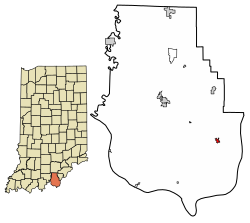
Harrison County Indiana Incorporated and Unincorporated areas Elizabeth Highlighted 1820674.svg
Location of Elizabeth in Harrison County, Indiana.
Coordinates: 38°7′27″N85°58′25″W / 38.12417°N 85.97361°W / 38.12417; -85.97361
Country United States
State Indiana
County Harrison
Township Posey
Area
[1]
  Total0.26 sq mi (0.68 km2)
  Land0.26 sq mi (0.68 km2)
  Water0.00 sq mi (0.00 km2)
Elevation
[2]
781 ft (238 m)
Population
 (2020)
  Total199
  Density762.45/sq mi (293.91/km2)
Time zone UTC-5 (EST)
  Summer (DST) UTC-4 (EDT)
ZIP code
47117
Area code 812
FIPS code 18-20674 [3]
GNIS feature ID2396924 [2]

Elizabeth is a town in Posey Township, Harrison County, Indiana, United States. The population was 162 at the 2010 census.

Contents

History

The original plat of the town of Elizabeth was recorded on April 17, 1812. [4] It was witnessed by Sheriff John Tipton. The land for the town was donated by Capt. Jacob Zenor and wife Suzannah Muchendorffer Zenor. The town is named after Jacob's daughter-in-law Elizabeth Lemmon Zenor wife of George Zenor.

Rose Hill Cemetery, the second largest cemetery in the county, is located on the west side of the town. The land for the cemetery was donated by Jacob Zenor and wife, with the only rule being that burial be made available regardless of the religious denomination of the deceased.

The town fire department was first organized by the town on December 29, 1959. The first fire engine was purchased in Corydon. It was a 1941 International Fire Truck, purchased for $200.

The first school in Elizabeth was a single room log cabin around 1833. Around 1890 seminary education first became available at Clay Hill College in downtown Elizabeth. The college was later moved and the high school eventually took over that building around 1908. The first graduation was held on April 13, 1912. The high school burned down in 1935. In 1936 Posey Township completed construction of a new brick school building. The building is still in use today, owned and operated by a local civic non-profit organization. The town's school children now attend South Central High School, which serves the entire south-eastern portion of Harrison County.

Geography

Elizabeth is located at 38°7′27″N85°58′25″W / 38.12417°N 85.97361°W / 38.12417; -85.97361 (38.124158, -85.973711). [5] According to the 2010 census, Elizabeth has a total area of 0.17 square miles (0.44 km2), all land. [6]

Climate

The climate in this area is characterized by hot, humid summers and generally mild to cool winters. According to the Köppen Climate Classification system, Elizabeth has a humid subtropical climate, abbreviated "Cfa" on climate maps. [7]

Government

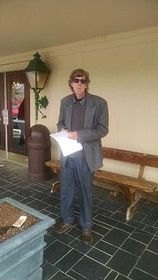
The Town of Elizabeth is governed by a three-member Town Council. Members elected in the 2015 Election were Alan Worral, Chris Fetz, and Mike Sampson. The current Clerk-Treasurer is Hugh Burns. He was elected in 2011 and reelected in 2015 and 2019. [8]

Elizabeth Clerk Treasurer Hugh Burns standing in front of the Elizabeth Town Hall Burns194513.jpg
Elizabeth Clerk Treasurer Hugh Burns standing in front of the Elizabeth Town Hall

Demographics

Historical population
CensusPop.Note
1870 216
1880 28230.6%
1890 267−5.3%
1900 2711.5%
1910 238−12.2%
1920 193−18.9%
1930 178−7.8%
1940 20917.4%
1950 2111.0%
1960 2141.4%
1970 195−8.9%
1980 178−8.7%
1990 153−14.0%
2000 137−10.5%
2010 16218.2%
2020 19922.8%
U.S. Decennial Census

2010 census

As of the census [9] of 2010, there were 162 people, 62 households, and 44 families living in the town. The population density was 952.9 inhabitants per square mile (367.9/km2). There were 73 housing units at an average density of 429.4 per square mile (165.8/km2). The racial makeup of the town was 96.3% White, 1.2% African American, 0.6% Native American, 1.2% from other races, and 0.6% from two or more races. Hispanic or Latino of any race were 1.2% of the population.

There were 62 households, of which 37.1% had children under the age of 18 living with them, 53.2% were married couples living together, 9.7% had a female householder with no husband present, 8.1% had a male householder with no wife present, and 29.0% were non-families. 24.2% of all households were made up of individuals, and 14.5% had someone living alone who was 65 years of age or older. The average household size was 2.61 and the average family size was 3.16.

The median age in the town was 33.9 years. 27.2% of residents were under the age of 18; 7.5% were between the ages of 18 and 24; 27.8% were from 25 to 44; 18.5% were from 45 to 64; and 19.1% were 65 years of age or older. The gender makeup of the town was 49.4% male and 50.6% female.

2000 census

As of the census [3] of 2000, there were 137 people, 53 households, and 36 families living in the town. The population density was 997.1 inhabitants per square mile (385.0/km2). There were 59 housing units at an average density of 429.4 per square mile (165.8/km2). The racial makeup of the town was 98.54% White, 0.73% from other races, and 0.73% from two or more races. Hispanic or Latino of any race were 0.73% of the population.

There were 53 households, of which 32.1% had children under the age of 18 living with them, 56.6% were married couples living together, 11.3% had a female householder with no husband present, and 30.2% were non-families. 26.4% of all households were made up of individuals, and 18.9% had someone living alone who was 65 years of age or older. The average household size was 2.58 and the average family size was 3.16.

The age distribution of the town was 27.0% under 18, 7.3% from 18 to 24, 26.3% from 25 to 44, 21.9% from 45 to 64, and 17.5% 65 or older. The median age was 37 years. For every 100 females, there were 80.3 males. For every 100 females age 18 and over, there were 75.4 males.

The median income for a household in the town was $31,563, and the median income for a family was $38,250. Males had a median income of $23,523 versus $19,063 for females. The per capita income for the town was $15,208. There were 8.6% of families and 10.2% of the population living below the poverty line, including no under eighteens and 31.1% of those over 64.

Education

Elizabeth has a public library, a branch of the Harrison County Public Library. [10]

Related Research Articles

<span class="mw-page-title-main">Palestine, Arkansas</span> Town in Arkansas, United States

Palestine is a town in St. Francis County, Arkansas, United States, along the L'Anguille River. The population was 681 at the 2010 census, a decline from 741 in 2000.

<span class="mw-page-title-main">Jonesville, Indiana</span> Town in Indiana, United States

Jonesville is a town in Wayne Township, Bartholomew County, in the U.S. state of Indiana. The population was 177 at the 2010 census. It is part of the Columbus, Indiana metropolitan statistical area.

<span class="mw-page-title-main">English, Indiana</span> Town in Indiana, United States

English is a town and the county seat of Crawford County, Indiana, United States. The population was 645 at the 2010 census, making it one of Indiana's smallest county seats. The settlement was named Hartford (1839-1884) prior to its incorporation.

<span class="mw-page-title-main">Milltown, Indiana</span> Town in Indiana, United States

Milltown is a town in Whiskey Run Township in Crawford County, Indiana and in Blue River and Spencer townships in Harrison County. The population was 818 at the time of the 2010 census.

<span class="mw-page-title-main">West Harrison, Indiana</span> Town in Indiana, United States

West Harrison is a town in Harrison Township, Dearborn County, Indiana, United States. The population was 289 at the 2010 census.

<span class="mw-page-title-main">Newberry, Indiana</span> Town in Indiana, United States

Newberry is a town in Cass Township, Greene County, Indiana, United States. The population was 193 at the 2010 census. It is part of the Bloomington, Indiana Metropolitan Statistical Area.

<span class="mw-page-title-main">Lanesville, Indiana</span> Town in Indiana, United States

Lanesville is a town in Franklin Township, Harrison County, Indiana, United States. The population was 935 at the 2010 census.

<span class="mw-page-title-main">New Middletown, Indiana</span> Town in Indiana, United States

New Middletown is a town in Webster Township, Harrison County, Indiana, United States. The population was 93 at the 2010 census.

<span class="mw-page-title-main">Palmyra, Indiana</span> Town in Indiana, United States

Palmyra is a town in Morgan Township, Harrison County, Indiana, United States. The population was 930 at the 2010 census.

<span class="mw-page-title-main">Whiteland, Indiana</span> Town in Indiana, United States

Whiteland is a town in Pleasant, Franklin and Clark townships, Johnson County, Indiana, United States. The population was 4,599 at the 2020 census.

<span class="mw-page-title-main">Lawrence, Indiana</span> City in Indiana, United States

Lawrence is a city in Marion County, Indiana, United States. It is one of four "excluded cities" in Marion County. The city is home to Fort Benjamin Harrison within Fort Harrison State Park. The population was 49,370 at the 2020 census. The city is on the northeast side of Indianapolis.

<span class="mw-page-title-main">Paoli, Indiana</span> Town in Indiana, United States

Paoli is a town within Paoli Township and the county seat of Orange County, in the U.S. state of Indiana. The population was 3,677 at the 2010 census.

<span class="mw-page-title-main">Spencer, Indiana</span> Town in Indiana, United States

Spencer is a town in Washington Township, Owen County, in the U.S. state of Indiana. The population was 2,217 at the 2010 census. It is the county seat of Owen County.

<span class="mw-page-title-main">Rockville, Indiana</span> Town in Indiana, United States

Rockville is a town in Adams Township, Parke County, in the U.S. state of Indiana. The population was 2,607 at the 2010 census. The town is the county seat of Parke County. It is known as "The Covered Bridge Capital of the World".

<span class="mw-page-title-main">Winslow, Indiana</span> Town in Indiana, United States

Winslow is a town in Patoka Township, Pike County, in the U.S. state of Indiana. The population was 864 at the 2010 census. It is part of the Jasper Micropolitan Statistical Area.

<span class="mw-page-title-main">Sunman, Indiana</span> Town in Indiana, United States

Sunman is a town in Adams Township, Ripley County, in the U.S. state of Indiana. The population was 1,049 at the 2010 census.

<span class="mw-page-title-main">Hardinsburg, Indiana</span> Census-designated place in Indiana, United States

Hardinsburg is a census-designated place in Posey Township, Washington County, in the U.S. state of Indiana. The population was 222 at the 2020 census.

<span class="mw-page-title-main">Poneto, Indiana</span> Town in Indiana, United States

Poneto is a town in Chester, Harrison and Liberty townships, Wells County, in the U.S. state of Indiana. The population was 166 at the 2010 census.

<span class="mw-page-title-main">Montrose, Mississippi</span> Town in Mississippi, United States

Montrose is a town in Jasper County, Mississippi, United States. The population was 140 at the 2010 census.

<span class="mw-page-title-main">Elizabeth, West Virginia</span> Town in West Virginia, United States

Elizabeth is a town in and the county seat of Wirt County, West Virginia, United States, situated along the Little Kanawha River. The population was 724 as of the 2020 census.

References

  1. "2020 U.S. Gazetteer Files". United States Census Bureau. Retrieved March 16, 2022.
  2. 1 2 U.S. Geological Survey Geographic Names Information System: Elizabeth, Indiana
  3. 1 2 "U.S. Census website". United States Census Bureau . Retrieved January 31, 2008.
  4. Roose, William H. (1911). Indiana's Birthplace: A History of Harrison County, Indiana. Tribune Company, Printers. p. 68.
  5. "US Gazetteer files: 2010, 2000, and 1990". United States Census Bureau. February 12, 2011. Retrieved April 23, 2011.
  6. "G001 - Geographic Identifiers - 2010 Census Summary File 1". United States Census Bureau. Archived from the original on February 13, 2020. Retrieved July 16, 2015.
  7. "Climate Summary for Elizabeth, Indiana". Weatherbase.com. Retrieved November 2, 2020.
  8. http://www.corydondemocrat.com/Articles-News-i-2015-07-28-228935.114125-Final-deadline-Monday-to-run-for-town-office.html%5B%5D
  9. "U.S. Census website". United States Census Bureau . Retrieved December 11, 2012.
  10. "Contact information". Harrison County Public Library. Archived from the original on February 27, 2018. Retrieved March 7, 2018.