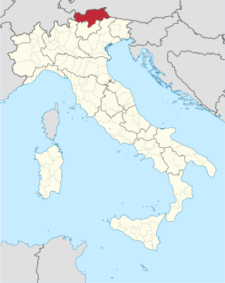
South Tyrol is an autonomous province in northern Italy. An English translation of the official German and Italian names could be the Autonomous Province of Bolzano – South Tyrol, reflecting the multilingualism and different naming conventions in the area. Together with the autonomous province of Trento, South Tyrol forms the autonomous region of Trentino-Alto Adige/Südtirol. The province is the northernmost of Italy, the second largest with an area of 7,400 square kilometres (2,857 sq mi), and has a total population of about 534,000 inhabitants as of 2021. Its capital and largest city is Bolzano.

Trentino-Alto Adige/Südtirol is an autonomous region of Italy, located in the northern part of the country. The region has a population of 1.1 million, of whom 62% speak Italian as their mother tongue, 30% speak South Tyrolean German and several foreign languages are spoken by immigrant communities. Since the 1970s, most legislative and administrative powers have been transferred to the two self-governing provinces that make up the region: the province of Trento, commonly known as Trentino, and the province of Bolzano, commonly known as South Tyrol. In South Tyrol, German remains the sizeable majority language.
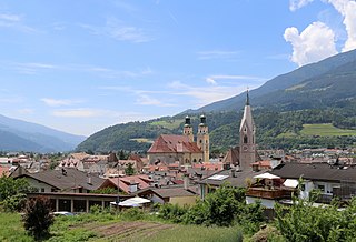
Brixen is a town and commune in South Tyrol, northern Italy, located about 40 kilometres (25 mi) north of Bolzano.
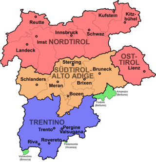
Modern-day South Tyrol, an autonomous Italian province created in 1948, was part of the Austro-Hungarian County of Tyrol until 1918. It was annexed by Italy following the defeat of the Central Powers in World War I. It has been part of a cross-border joint entity, the Euroregion Tyrol-South Tyrol-Trentino, since 2001.

Ahrntal is a comune (municipality) in South Tyrol in northern Italy, located about 70 kilometres (43 mi) northeast of the city of Bolzano (Bozen), near the border to Austria.
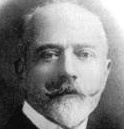
Ettore Tolomei was an Italian nationalist and fascist. He was designated a Member of the Italian Senate in 1923, and ennobled as Conte della Vetta in 1937.

The Tre Cime di Lavaredo, also called the Drei Zinnen ; pronounced[ˌdʁaɪˈtsɪnən] ), are three distinctive battlement-like peaks, in the Sexten Dolomites of northeastern Italy. They are one of the best-known mountain groups in the Alps. The three peaks, from east to west, are:

The South Tyrol Alpine Club, abbreviated AVS, is an association of German and Ladin-speaking mountain climbers in South Tyrol, northern Italy. Founded in 1946, it is subdivided into 32 sections and 58 local divisions. The AVS is based in Bolzano and has more than 60,000 members.

The Hoher Weißzint is a mountain in the Zillertal Alps on the border between Tyrol, Austria, and South Tyrol, Italy.
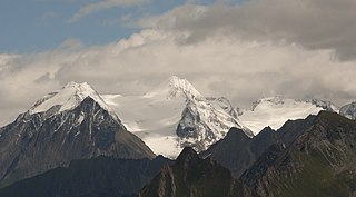
The Hochfeiler is a mountain, 3,510 metres high, and the highest peak in the Zillertal Alps on the border between Tyrol, Austria, and South Tyrol, Italy.

The III. Hornspitze is a mountain in the Zillertal Alps on the border between Tyrol, Austria, and South Tyrol, Italy.
Tyrol is a historical region in the Alps of Northern Italy and western Austria. The area was historically the core of the County of Tyrol, part of the Holy Roman Empire, Austrian Empire and Austria-Hungary, from its formation in the 12th century until 1919. In 1919, following World War I and the dissolution of Austria-Hungary, it was divided into two modern administrative parts through the Treaty of Saint-Germain-en-Laye:

The Olperer is a 3,476-metre-high (11,404 ft) mountain in the Zillertal Alps in the Austrian federal state of Tyrol. It is the main summit on the Tux Crest and is often crossed in the summer as climbers transit from the Olperer Hut to the Geraer Hut. It was first climbed on 10 September 1867 along the southeast ridge (Südostgrat) by Paul Grohmann, Georg Samer and Gainer Jackl. On its north flank is the ski region known as Hintertux Glacier on the Gefrorene-Wand-Kees glacier.

The Gefrorene-Wand-Spitzen are two summits on the Tux Crest, a mountain chain in the Zillertal Alps, one of the ranges of the central Eastern Alps in the Austrian state of Tyrol. The north summit (Nordgipfel) is recorded as 3,286 metres high in the literature, but is 3,288 metres high according to the Federal Office for Metrology and Survey. The south summit (Südgipfel), by contrast, is only 3,270 metres high. The two peaks are about 300 metres apart. They appear from the north as a stubby, cone-shaped, firn-covered dome, but from the east as a forbidding, dark rock face. Sharp, prominent ridges radiate from the peaks to the northeast and southwest, along the main crest of the mountain range. The twin peaks are the highest points in the summer skiing area of the Hintertux Glacier and, since the end of the 1990s, have been accessible from Hintertux on cable cars and ski lifts; which makes them a popular destination for day trippers. The north summit was first conquered in 1867 by Dr. Berreitter, the south summit on 7 September 1872 by brothers Max and Richard von Frey from Salzburg.

The Reichenspitze is a mountain, 3,303 m (AA), in the eastern Zillertal Alps on the border between the Austrian states of Salzburg and Tyrol. It is the highest peak of the range named after it, the Reichenspitze Group, and offers good, all-round views. Its neighbouring peaks, all linked by arêtes, are the 3,263-metre-high Gabler to the northeast, the Richterspitze to the south and the 3,278-metre-high Wildgerlosspitze to the northwest.

The Große Möseler, also called the Mösele, is a mountain, 3,480 m (AA), and thus the second highest peak in the Zillertal Alps after the Hochfeiler (3,509 m). It lies on the Zillertal main ridge which forms the border here between the Austrian state of Tyrol and the Italian province of South Tyrol. Its great size makes it the dominant mountain in the area. Seen from the northwest it appears like a firn-covered dome; but from the northeast as a regularly shaped cone of rock. Prominent arêtes radiate from the peak to the northwest, east and south. The mountain is easily ascended from the Furtschaglhaus and is often visited as a result. It was first climbed on 16 June 1865 by G. H. Fox, Douglas William Freshfield and Francis Fox Tuckett with mountain guides, François Devouassoud from Chamonix and Peter Michel from Grindelwald, as well as two unknown bearers.

At 3,474 m (AA) the Ruderhofspitze is the fourth highest mountain in the Stubai Alps in Austria. It is part of the Alpein Mountains and lies in the Austrian state of Tyrol. As a result of its topographic isolation and good all-round views it is one of the most visited mountains in the Stubai. An almost two-kilometre-long arête, the Grawawand, runs away from the summit to the east. Less prominent ridges run south and northwestwards from the Ruderhofspitze. The peak was first ascended on 30 August 1864 by Karl Baedeker, Anton von Ruthner and mountain guides Pankraz Gleinser and Alois Tanzer.
The Jochköpfl is a mountain, 3,143 m (AA), on the Windach-Brunnenkogel-Kamm, a subgroup of the Stubai Alps in Austria.
The Westliches Zwillingsköpfl, is a 2,835-metre (9,301 ft) mountain peak on the border of Italy and Austria. The Westliches Zwillingsköpfl is the northernmost point of Italy, even though the nearby Glockenkarkopf is often considered to hold this distinction. The first known ascent of the Westliches Zwillingsköpfl was made on 9 July 1895 by Franz Hofer and Fritz Koegl, who published an account of their tour in the journal of the Österreichischer Alpenverein in 1897.

