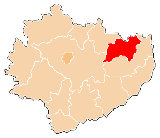
| Gmina Wąchock Wąchock Commune | ||
|---|---|---|
| Gmina | ||
| ||
| Coordinates(Wąchock): 51°4′27″N21°0′49″E / 51.07417°N 21.01361°E Coordinates: 51°4′27″N21°0′49″E / 51.07417°N 21.01361°E | ||
| Country | ||
| Voivodeship | Świętokrzyskie | |
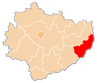
| County | Starachowice | |
| Seat | Wąchock | |
| Area | ||
| • Total | 81.84 km2 (31.60 sq mi) | |
| Population (2006) | ||
| • Total | 6,972 | |
| • Density | 85/km2 (220/sq mi) | |
| • Urban | 2,760 | |
| • Rural | 4,212 | |
| Website | http://www.wachock.pl | |

Gmina Wąchock is an urban-rural gmina (administrative district) in Starachowice County, Świętokrzyskie Voivodeship, in south-central Poland. Its seat is the town of Wąchock, which lies approximately 5 kilometres (3 mi) north-west of Starachowice and 35 km (22 mi) north-east of the regional capital Kielce.

The gmina is the principal unit of the administrative division of Poland, similar to a municipality. As of 2010 there were 2,478 gminy throughout the country. The word gmina derives from the German word Gemeinde, meaning "community".
Starachowice County is a unit of territorial administration and local government (powiat) in Świętokrzyskie Voivodeship, south-central Poland. It came into being on January 1, 1999, as a result of the Polish local government reforms passed in 1998. Its administrative seat and largest town is Starachowice, which lies 37 kilometres (23 mi) north-east of the regional capital Kielce. The only other town in the county is Wąchock, lying 5 km (3 mi) north-west of Starachowice.
Świętokrzyskie Voivodeship, Świętokrzyskie Province, or Holy Cross Province is one of the 16 voivodeships (provinces) into which Poland is divided. It is situated in southeastern Poland, in the historical province of Lesser Poland, and takes its name from the Świętokrzyskie mountain range. Its capital and largest city is Kielce.
Contents
The gmina covers an area of 81.84 square kilometres (31.6 sq mi), and as of 2006 its total population is 6,972 (out of which the population of Wąchock amounts to 2,760, and the population of the rural part of the gmina is 4,212).
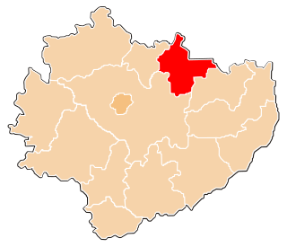
The gmina contains part of the protected area called Sieradowice Landscape Park.

Protected areas or conservation areas are locations which receive protection because of their recognized natural, ecological or cultural values. There are several kinds of protected areas, which vary by level of protection depending on the enabling laws of each country or the regulations of the international organizations involved.
Sieradowice Landscape Park is a protected area in south-central Poland, covering an area of 121.06 square kilometres (46.74 sq mi).