
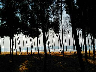
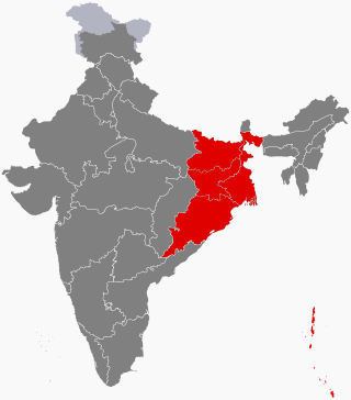
Odisha, formerly Orissa, is an Indian state located in Eastern India. It is the 8th-largest state by area, and the 11th-largest by population, with over 41 million inhabitants. The state also has the third-largest population of Scheduled Tribes in India. It neighbours the states of Jharkhand and West Bengal to the north, Chhattisgarh to the west, and Andhra Pradesh to the south. Odisha has a coastline of 485 kilometres (301 mi) along the Bay of Bengal in Indian Ocean. The region is also known as Utkala and is mentioned by this name in India's national anthem, "Jana Gana Mana". The language of Odisha is Odia, which is one of the Classical Languages of India.

Jagannatha is a deity worshipped in regional Hindu traditions in India and Bangladesh as part of a triad along with his brother Balabhadra, and sister, Subhadra. Jagannath, within Odia Hinduism, is the supreme god, Purushottama, and the Para Brahman. To most Vaishnava Hindus, particularly the Krishnaites, Jagannath is an abstract representation of Krishna, or Vishnu, sometimes as the avatar of Krishna or Vishnu. To some Shaiva and Shakta Hindus, he is a symmetry-filled tantric form of Bhairava, a fierce manifestation of Shiva associated with annihilation.
Baripada is a city and a municipality in Mayurbhanj district in the state of Odisha, India. Located along the east bank of the Budhabalanga river, Baripada is the cultural centre of north Odisha. In recent years, it has emerged as an educational hub with the opening of numerous professional colleges.

Chilika Lake is the largest brackish water lagoon in Asia and second largest coastal lagoon in the world, spread over the Puri, Khordha and Ganjam districts of Odisha state on the east coast of India, at the mouth of the Daya River, flowing into the Bay of Bengal, covering an area of over 1,100 square kilometres (420 sq mi). Another lake in India called Vembanad Lake is the longest lake in India. Chilika Lake comes after the New Caledonian barrier reef. It has been listed as a tentative UNESCO World Heritage site. Its salinity varies by region, from nearly freshwater where rivers flow in, to oceanic salinity levels due to tidal influx.

Brahmapur is a city on the eastern coastline of India.

Cuttack in Odia, is the former capital and the second largest city in the Indian state of Odisha. It is the headquarters of the Cuttack district. The name of the city is an anglicised form of the Odia and Sanskrit name Kataka which literally means The Fort, a reference to the ancient Barabati Fort around which the city initially developed. Cuttack is known as the Millennium City as well as the Silver City due to its history of 1000 years and famous silver filigree works. The Orissa High Court is located there. It is the commercial capital of Odisha which hosts many trading and business houses in and around the city. Cuttack is famous for its Durga Puja which is one of the most important festivals of Odisha. Cuttack is also the birthplace of Indian nationalist & freedom fighter Netaji Subhas Chandra Bose from Bengal. The city is categorised as a Tier-II city as per the ranking system used by Government of India.

Kalahandi district is a district of Odisha in India. Archaeological evidence of Stone Age and Iron Age human settlement has been recovered from the region. Asurgarh offered an advanced, well civilised, cultured and urban human settlement about 2000 years ago in the region. In South Asia it is believed that the lands of Kalahandi district and Koraput district were the ancient places where people started cultivation of paddy. In ancient time it was known as Mahakantara and Karunda Mandal, which means treasure of precious stones like karandam (corundum/manik), garnet, beruz, neelam, and alexandrite, etc. Manikeswari is the clan deity of Kalahandi may also signify its historical name.
Puri district is a coastal district of the Odisha state of India. It has one sub-division, 11 tahasils and 11 blocks and comprises 1722 revenue villages. Puri is the only municipality of the district. Konark, Pipili and Nimapara are the three NACs in this district. Satyabadi, Gop, Kakatpur and Brahmagiri are major semi-urban areas.
East India is a region of India consisting of the Indian states of Bihar, Jharkhand, Odisha and West Bengal and also the union territory of the Andaman and Nicobar Islands. The region roughly corresponds to the historical region of Magadha from which it inherits its various Eastern Indo-Aryan languages.

Ganjam is a town and a notified area council in Ganjam district in the state of Odisha, India. Brahmapur, one of the major city of Odisha is situated in this district.

The history of Odisha begins in the Lower Paleolithic era, as Acheulian tools dating to the period have been discovered in various places in the region. The early history of Odisha can be traced back to writings found in ancient texts like the Mahabharata, Maha Govinda Sutta and some Puranas. The region was also known to other kingdoms in region of East Indies due to maritime trade relations.

Odisha is one of the 28 states in the Republic of India. Odisha is located in the eastern part of the Indian peninsula and the Bay of Bengal lies to its East while Chhattisgarh shares its border in the west and north-west. The state also shares geographic boundaries with West Bengal in the north-east, Jharkhand in the north and Andhra Pradesh in the south. The state is spread over an area of 1,55,707 km2 and extends for 700 km from north to south and 500 kilometres from east to west. Its coastline is 450 km long. The state is divided into 30 districts which are further subdivided into 314 blocks.

Odisha, a state in eastern India, is extremely diverse and gives the state abundance of natural beauty and wildlife. The districts in the interior are thickly covered by tropical moist deciduous and tropical dry deciduous forests. The hills, plateaus and isolated areas of the northeastern part of the state are covered by the tropical moist deciduous forests whereas the dry deciduous forests are located in the southwest region of the state. Some of the trees which grow in abundance in Odisha are bamboo, teak, rosewood, sal, piasal, sanghvan and haldi. There are 479 species of birds, 86 species of mammals, 19 species of amphibians and 110 species of reptiles present in Odisha. The state is also an important habitat for the endangered olive ridley turtles and Irrawaddy dolphins. Koraput district of southern Odisha has been identified by Food and Agriculture Organisation (FAO) of UN as Global Agricultural Heritage site which is among only other three sites in the world. Other sites are in Peru, China and Philippines.
The history of Kalahandi goes back to the primitive period where a well-civilized, urbanized, and cultured people inhabited this land mass around 2000 years ago. The world's largest celt of Stone Age and the largest cemetery of the megalithic age have been discovered in Kalahandi. This shows the region had a civilized culture since the pre-historic era. Asurgarh near Narla in Kalahandi was one of the oldest metropolises in Odisha whereas the other one was Sisupalgarh near Bhubaneswar. Some other historical forts in the region includes Budhigarh, Amthagarh, Belkhandi and Dadpur-Jajjaldeypur. This land was unconquered by the great Ashoka, who fought the great Kalinga War, as per Ashokan record. In medieval period the region had played a prominent role to link South India, Eastern India and Central India region and witnessed the battle ground for Somavamsi, Chola, Kalachuris of Kalyani and Eastern Ganga dynasty. Kalahandi region was the main route for Chola to attack Subarnapur.

The Maritime history of Odisha, known as Kalinga in ancient times, started much before 800 BC according to early sources. The people of this region of eastern India along the coast of the Bay of Bengal sailed up and down the Indian coast, and travelled to Indo China and throughout Maritime Southeast Asia, introducing elements of their culture to the people with whom they traded. The 6th century Manjusrimulakalpa mentions the Bay of Bengal as Kalingodra and in ancient Classical India, the Bay of Bengal was known as Kalinga Sagar, indicating the importance of Kalinga in the maritime trade. The old traditions are still celebrated in the annual Boita Bandana festival including its major celebration at Cuttack on the banks of Mahanadi river called Bali Jatra, and are held for seven days in October-November at various coastal districts, most famous at Cuttack though.

Hasmukh Dhirajlal Sankalia was an Indian Sanskrit scholar and archaeologist specialising in proto- and ancient Indian history. He is considered to have pioneered archaeological excavation techniques in India, with several significant discoveries from the prehistoric period to his credit. Sankalia received the Ranjitram Suvarna Chandrak award in 1966. And also received Padma Bhushan in the year 1974.
Aul is a town and the headquarters of Aul CD Block and Aul Tehsil in Kendrapara district in the Indian state of Odisha. It is 17 km from Chandabali. Aul is surrounded by the river Kharasrota and Brahmani on north and south respectively. To its east is Bhitarkanika National Park.
Gopal or Gauda is an Indian caste, from Odisha State in East India. Their traditional occupations include dairy farming, cattle herding, cultivation and carrying palanquins of deities. They also worked as Paikas (soldiers) under the kings. Gopal is the name of the milkmen or herdsmen caste in Odisha, which is known by other names in various parts of India.

