
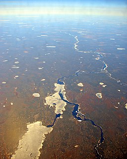
Victoria Island is a large island in the Arctic Archipelago that straddles the boundary between Nunavut and the Northwest Territories of Canada. It is the eighth largest island in the world, and at 217,291 km2 (83,897 sq mi) in area, it is Canada's second largest island. It is nearly double the size of Newfoundland (111,390 km2 [43,008 sq mi]), and is slightly larger than the island of Great Britain (209,331 km2 [80,823 sq mi]) but smaller than Honshu (225,800 km2 [87,182 sq mi]). The western third of the island lies in the Inuvik Region of the Northwest Territories; the remainder is part of Nunavut's Kitikmeot Region.
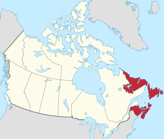
Atlantic Canada, also called the Atlantic provinces, is the region of Eastern Canada comprising the provinces located on the Atlantic coast, excluding Quebec: the three Maritime Provinces – New Brunswick, Nova Scotia, and Prince Edward Island – and the easternmost province of Newfoundland and Labrador. The population of the four Atlantic provinces in 2016 was about 2,300,000 on half a million km2. The provinces combined had an approximate GDP of $121.888 billion in 2011. The term Atlantic Canada was popularized following the admission of Newfoundland as a Canadian province in 1949.

The Ottawa River is a river in the Canadian provinces of Ontario and Quebec. It is named in honour of the Algonquin word 'to trade', as it was the major trade route of Eastern Canada at the time. For most of its length, it defines the border between these two provinces. It is a major tributary of the St. Lawrence River and the longest river in Quebec.

The Rideau River is a river in Eastern Ontario, Canada. The river flows north from Upper Rideau Lake and empties into the Ottawa River at the Rideau Falls in Ottawa, Ontario. Its length is 146 kilometres (91 mi).

Stratford is a town located in Queens County, Prince Edward Island.
The Albany River is a river in Northern Ontario, Canada, which flows northeast from Lake St. Joseph in Northwestern Ontario and empties into James Bay. It is 982 kilometres (610 mi) long to the head of the Cat River, tying it with the Severn River for the title of longest river in Ontario. Major tributaries include the Kenogami River and Ogoki River.
Souris is a town in Kings County, Prince Edward Island, Canada. It is located near the northeastern tip of the province.
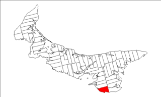
Lot 62 is a township in Queens County, Prince Edward Island, part of St. John's Parish. Lot 62 was awarded to Richard Spry, Esquire in the 1767 Land Lottery, and came to be settled through the efforts of Thomas Douglas, The 5th Earl of Selkirk in 1803. Richard Spry, Esquire, was then Commodore, Commander-in-Chief, Mediterranean Fleet at Gibraltar 1766–1769. Becoming the proprietor, he would be familiar with then the Island of St. John, having first come out to North America in 1754, with the English naval blockade of Ile Royal and the Fortress of Louisbourg in 1756, and then serving off Quebec and in the St. Lawrence into 1759. In 1762, he returned as Commander-in-Chief, North America, quartered in Halifax.

Georgetown is a community located within the municipality of Three Rivers in Kings County, Prince Edward Island, Canada. It is the Capital of Kings County. Previously incorporated as a town, it amalgamated with the town of Montague, the rural municipalities of Brudenell, Cardigan, Lorne Valley, Lower Montague, and Valleyfield, and portions of three adjacent unincorporated areas in 2018.

Caribou is a small rural community in Pictou County, Nova Scotia, Canada.

Batchawana Bay is a small bay in Algoma District in Northeastern Ontario, Canada. It is on the eastern shore of Lake Superior, approximately 50 kilometres (31 mi) north of Sault Ste. Marie.
Malpeque Bay is a 204 km2 (79 sq mi) estuarine bay on the north shore of Prince Edward Island, Canada.

Tahiryuaq, formerly Tahiryuak Lake, is a lake located in the Canadian Arctic's Northwest Territories. It is situated in northcentral Victoria Island, north of Prince Albert Sound, southeast of Minto Inlet.

Night Hawk Lake is a lake in the city of Timmins, Cochrane District in northeastern Ontario, Canada. It is in the James Bay drainage basin and is the source of the Frederick House River, which flows via the Abitibi River and Moose River to James Bay. Night Hawk Lake is the largest lake within the boundaries of the City of Timmins.
Cedar Lake may refer to one of eighteen lakes of that name in Ontario, Canada:

Resort Municipality, officially named the Resort Municipality of Stanley Bridge, Hope River, Bayview, Cavendish and North Rustico, is the lone municipality in Prince Edward Island, Canada that holds resort municipality status. It was established in 1990.
Goose River is a river in the Hudson Bay drainage basin in the Northern Region of Manitoba and Division No. 18 in Saskatchewan, Canada, approximately 19 kilometres (12 mi) southeast of Bakers Narrows.
The Goose River is a short river in the community of Goose River in Kings County, Prince Edward Island, Canada. It lies on the northeast shore of the province and flows 600 metres (2,000 ft) from its source in an unnamed field northwest to the Gulf of Saint Lawrence. It has one unnamed left tributary that enters 200 metres (660 ft) downstream from the river's source.
