Stratford is a town located in Queens County, Prince Edward Island.

The Queen Elizabeth Islands are the northernmost cluster of islands in Canada's Arctic Archipelago, split between Nunavut and the Northwest Territories in Northern Canada. The Queen Elizabeth Islands contain approximately 14% of the global glacier and ice cap area..

Alexander Island is one of the Canadian arctic islands located in Nunavut, Canada. It lies south of Massey Island and Île Marc, and north of Bathurst Island. Located at 75°52'N 102°37'W it has an area of 484 km2 (187 sq mi), 42.8 kilometres (26.6 mi) long and 19 kilometres (12 mi) wide.

Lot 50 is a township in Queens County, Prince Edward Island, Canada. It is part of St. John's Parish. Lot 50 was awarded to Henry Gladwin and Captain Peter Innes in the 1767 land lottery. One quarter of the lot was granted to Loyalists in 1783.

Lot 60 is a township in Queens County, Prince Edward Island, Canada. It is part of St. John's Parish. In the 1767 land lottery, Lot 60 was awarded to Major John Wrightson and Captain Daniel Shaw of the 42nd Regiment of Foot.
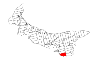
Lot 62 is a township in Queens County, Prince Edward Island, part of St. John's Parish. Lot 62 was awarded to Richard Spry, Esquire in the 1767 Land Lottery, and came to be settled through the efforts of Thomas Douglas, The 5th Earl of Selkirk in 1803. Richard Spry, Esquire, was then Commodore, Commander-in-Chief, Mediterranean Fleet at Gibraltar 1766–1769. Becoming the proprietor, he would be familiar with then the Island of St. John, having first come out to North America in 1754, with the English naval blockade of Ile Royal and the Fortress of Louisbourg in 1756, and then serving off Quebec and in the St. Lawrence into 1759. In 1762, he returned as Commander-in-Chief, North America, quartered in Halifax.

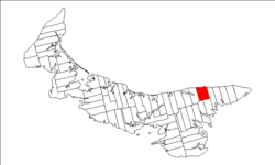
Lot 38 is a township in Kings County, Prince Edward Island, Canada. It is part of St. Patrick's Parish. Lot 38 was one of four lots awarded to the officers of the 78th Fraser Highlanders in the 1767 land lottery.

Lot 41 is a township in Kings County, Prince Edward Island, Canada. It is part of St. Patrick's Parish. Lot 41 was one of four lots awarded to the officers of the 78th Fraser Highlanders in the 1767 land lottery.

Bedford Parish was created as a civil parish in Queens County, Prince Edward Island, Canada, during the 1764-1766 survey of Samuel Holland.

St. Patrick's Parish was created as a civil parish in Kings County, Prince Edward Island, Canada, during the 1764-1766 survey of Samuel Holland.

Collinson Point Provincial Park is a provincial park on Galiano Island, British Columbia, Canada. It is located between Mount Galiano and the western approaches to Active Pass. The area is 24 hectares, with c. 500 metres of waterfront.
Ruxton Island is one of the six islands in the De Courcy Islands group. It is one of the southern Gulf Islands in British Columbia. It is due south-east of DeCourcy Island, being separated by Ruxton Passage.

Mohawk Island is a small island in Lake Erie, in the province of Ontario, Canada. It was formerly known as Gull Island. The island contains the ruins of the Gull Island Lighthouse, built in 1848 to guide ships into the Welland Canal. It was automated in 1933, and decommissioned in 1969. It is located close to the shore of Rock Point Provincial Park. The lantern room and stairs inside the lighthouse were removed, and the wood roof, the lighthouse keeper, door and windows are missing.

Charlottetown is the capital and largest city of the Canadian province of Prince Edward Island, and the county seat of Queens County. Named after Charlotte of Mecklenburg-Strelitz, queen consort of King George III of the United Kingdom, Charlottetown was originally an unincorporated town that incorporated as a city in 1855.
Tignish Shore is a municipality that holds community status in Prince Edward Island, Canada. It is located in the Lot 1 township.
The Municipality of Lot 11 and Area is a municipality that holds community status in Prince Edward Island, Canada. It is located within Prince County.

Resort Municipality, officially named the Resort Municipality of Stanley Bridge, Hope River, Bayview, Cavendish and North Rustico, is the lone municipality in Prince Edward Island, Canada that holds resort municipality status. It was established in 1990.
Long River is an unincorporated community, in Queens County. Long River is in Lot 20 of Statistics Canada
Goose River is an unincorporated place in Kings County, Prince Edward Island, Canada. It lies on the north shore of the province along Prince Edward Island Route 16 between Cable Head East to the southwest and Monticello to the northeast. Goose River is part of the township of Lot 42, in St Patrick's Parish, and thus is part of Lot 42 for Statistics Canada census data.