
Annapolis County is a county in the Canadian province of Nova Scotia located in the western part of the province located on the Bay of Fundy. The county seat is Annapolis Royal.

Estrie is an administrative region of Quebec that comprises the Eastern Townships. Estrie, a French neologism, was coined as a derivative of est, "east". Originally settled by anglophones, today it is about 90 per cent francophone. Anglophones are concentrated in Lennoxville, home of the region's only English-speaking university, Bishop's University. The Eastern Townships School Board runs 20 elementary schools, three high schools, and a learning centre.

Stratford is a town located in Queens County, Prince Edward Island.
Summerside is a Canadian city in Prince County, Prince Edward Island. It is the second largest city in the province and the primary service centre for the western part of the island.

Duncan is a city on southern Vancouver Island in British Columbia, Canada. It is the smallest city by area in Canada. It was incorporated in 1912.

North Cowichan is a district municipality established in 1873 on Vancouver Island, in British Columbia, Canada. The municipality is part of the Cowichan Valley Regional District. North Cowichan is noted for a landscape including forests, beaches, rivers, and lakes. The municipality encompasses the communities of Chemainus; Westholme; Crofton; Maple Bay; and "the South End". The latter is an informal name for a built-up area which is essentially a suburb of the City of Duncan, a separate municipality.

The Cowichan Valley Regional District is a regional district in the Canadian province of British Columbia is on the southern part of Vancouver Island, bordered by the Nanaimo and Alberni-Clayoquot Regional Districts to the north and northwest, and by the Capital Regional District to the south and east. As of the 2021 Census, the Regional District had a population of 89,013. The regional district offices are in Duncan.

Port Hardy is a district municipality in British Columbia, Canada located on the north-east end of Vancouver Island. Port Hardy has a population of 3,902 as of the 2021 census.

Lot 15 is a township in Prince County, Prince Edward Island, Canada. It is part of Richmond Parish. Lot 15 was awarded to Guy Carleton, 1st Baron Dorchester in the 1767 land lottery.

Lot 17 is a township in Prince County, Prince Edward Island, Canada. It is part of Richmond Parish. Lot 17 was awarded to Bingham and Theobold Burke in the 1767 land lottery. Half of it had been sold for arrears of quitrent by 1781, and one quarter was granted to Loyalists. Six-thousand acres were sold to Acadians in 1800.
Lot 25 is a township in Prince County, Prince Edward Island, Canada. It is part of St. David's Parish. Lot 25 was awarded to Archibald Kennedy and James Campbell in the 1767 land lottery. One half was sold for arrears in quitrent in 1781.
Alberton is a Canadian town located in Prince County, Prince Edward Island. It is situated in the western part of the county in the township of Lot 5.
The Regional District of Fraser–Fort George (RDFFG) is a regional district located in the Central Interior of British Columbia, Canada. It is bounded by the Alberta border to the east, the Columbia–Shuswap and Thompson–Nicola regional districts to the south and southeast, Cariboo Regional District to the southwest, the Regional District of Bulkley–Nechako to the west, and the Peace River Regional District to the north and northeast. As of the Canada 2011 Census, Fraser–Fort George had a population of 91,879 and a land area of 51,083.73 km2. The offices of the regional district are located at Prince George.

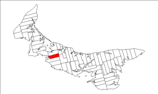
Prince County is located in western Prince Edward Island, Canada. The county's defining geographic feature is Malpeque Bay, a sub-basin of the Gulf of St. Lawrence, which creates the narrowest portion of Prince Edward Island's landmass, an isthmus upon which the city of Summerside is located.

Kensington is a Canadian town located in Prince County, Prince Edward Island. It is 15 km (9.3 mi) northeast of the city of Summerside. In 2021, its population was 1,812 and is seeing rapid growth thanks in part to a recently opened business park.
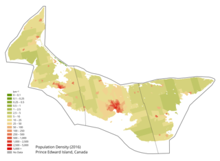
Prince Edward Island is a Canadian province. According to the 2011 National Household Survey, the largest ethnic group consists of people of Scottish descent (39.2%), followed by English (31.1%), Irish (30.4%), French (21.1%), German (5.2%), and Dutch (3.1%) descent. Prince Edward Island is mostly a white community and there are few visible minorities. Chinese people are the largest visible minority group of Prince Edward Island, comprising 1.3% of the province's population. Almost half of respondents identified their ethnicity as "Canadian." Prince Edward Island is by a strong margin the most Celtic and specifically the most Scottish province in Canada and perhaps the most Scottish place (ethnically) in the world, outside Scotland. 38% of islanders claim Scottish ancestry, but this is an underestimate and it is thought that almost 50% of islanders have Scottish roots. When combined with Irish and Welsh, almost 80% of islanders are of some Celtic stock, albeit most families have resided in PEI for at least two centuries. Few places outside Europe can claim such a homogeneous Celtic ethnic background. The only other jurisdiction in North America with such a high percentage of British Isles heritage is Newfoundland.
Abram-Village is a rural municipality in Prince County, Prince Edward Island, Canada.
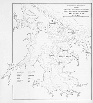
Malpeque Bay is a 204 km2 (79 sq mi) estuarine bay on the north shore of Prince Edward Island, Canada.
A designated place (DPL) is a type of community or settlement identified by Statistics Canada that does not meet the criteria used to define municipalities or population centres. DPLs are delineated every 5 years for the Canadian census as the statistical counterparts of incorporated places such as cities, towns, and villages.
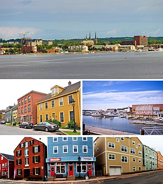
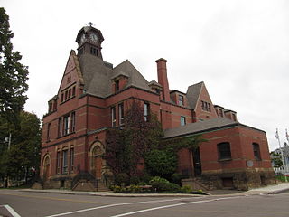
Charlottetown is the capital and largest city of the Canadian province of Prince Edward Island, and the county seat of Queens County. Named after Queen Charlotte, Charlottetown was an unincorporated town until it was incorporated as a city in 1855.
