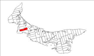
Lot 18, Prince Edward Island

Last updated
Lot 18
Township
Map of Prince Edward Island highlighting Lot 18.png
Map of Prince Edward Island highlighting Lot 18
Coordinates: 46°30′N63°40′W / 46.500°N 63.667°W / 46.500; -63.667 Coordinates: 46°30′N63°40′W / 46.500°N 63.667°W / 46.500; -63.667
Country Canada
Province Prince Edward Island
County Prince County
Parish St. David's Parish
Area
  Total 92.95 km2 (35.89 sq mi)
Population (2006)
  Total 1,055
  Density 11.4/km2 (30/sq mi)
Time zone AST (UTC-4)
  Summer (DST) ADT (UTC-3)
Canadian Postal code C0B
Area code(s) 902
NTS Map 011L12
GNBC Code BAERE

Lot 18 is a township in Prince County, Prince Edward Island, Canada. It is part of St. David's Parish. Lot 18 was awarded to John Stewart and William Allanby in the 1767 land lottery. [1]

Prince County, Prince Edward Island Place

Prince County is located in western Prince Edward Island, Canada. The county's defining geographic feature is Malpeque Bay, a sub-basin of the Gulf of St. Lawrence, which creates the narrowest portion of Prince Edward Island's landmass, an isthmus upon which the city of Summerside is located.
Prince Edward Island Province of Canada

Prince Edward Island is a province of Canada consisting of the Atlantic island of the same name along with several much smaller islands nearby. PEI is one of the three Maritime Provinces. It is the smallest province of Canada in both land area and population, but it is the most densely populated. Part of the traditional lands of the Mi'kmaq, it became a British colony in the 1700s and was federated into Canada as a province in 1873. Its capital is Charlottetown. According to the 2016 census, the province of PEI has 142,907 residents.

Canada Country in North America

Canada is a country in the northern part of North America. Its ten provinces and three territories extend from the Atlantic to the Pacific and northward into the Arctic Ocean, covering 9.98 million square kilometres, making it the world's second-largest country by total area. Canada's southern border with the United States is the world's longest bi-national land border. Its capital is Ottawa, and its three largest metropolitan areas are Toronto, Montreal, and Vancouver. As a whole, Canada is sparsely populated, the majority of its land area being dominated by forest and tundra. Consequently, its population is highly urbanized, with over 80 percent of its inhabitants concentrated in large and medium-sized cities, many near the southern border. Canada's climate varies widely across its vast area, ranging from arctic weather in the north, to hot summers in the southern regions, with four distinct seasons.
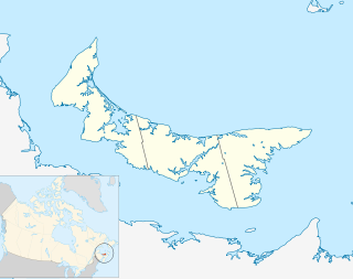
Communities

Incorporated municipalities:

Civic address communities:

Burlington is an unincorporated area located in Prince County in western Prince Edward Island just north-east of Kensington. It is the site of the Burlington Amusement Park (go-carts) and the former Woodleigh Replicas, a once-popular tourist destination.

Indian River, Prince Edward Island Unincorporated Area in Prince Edward Island, Canada

Indian River is an unincorporated area in Prince County in the Canadian province of Prince Edward Island.

Related Research Articles

Progressive Conservative Party of Prince Edward Island political party in Prince Edward Island, Canada

The Progressive Conservative Party of Prince Edward Island is one of two major political parties on Prince Edward Island. It and its rival, the Liberals have alternated in power since responsible government was granted in 1851.

Wayne Easter Canadian politician

Wayne Easter is a Canadian politician who has been the elected member of parliament for the riding of Malpeque since 1993.

Malpeque can refer to several different things:

Kensington-Malpeque Provincial electoral district in Prince Edward Island

Kensington-Malpeque is a provincial electoral district for the Legislative Assembly of Prince Edward Island, Canada.

Lot 20, Prince Edward Island Township in Prince Edward Island, Canada

Lot 20 is a township in Queens County, Prince Edward Island, Canada. It is part of Greenville Parish. Lot 20 was awarded to Theodore Houltain and Thomas Basset in the 1767 land lottery.

Lot 16, Prince Edward Island Township in Prince Edward Island, Canada

Lot 16 is a township in Prince County, Prince Edward Island, Canada. It is part of Richmond Parish.

Prince Royalty, Prince Edward Island human settlement in Prince Edward Island, Canada

Prince Royalty is the royalty for Prince County, Prince Edward Island, Canada.

Cabot Beach Provincial Park provincial park in Prince Edward Island, Canada

Cabot Beach Provincial Park is a provincial park in Prince Edward Island, Canada. It is located in Malpeque Bay.

Belmont is a Canadian rural farming community located in the larger community of Lot 16 in central Prince County, Prince Edward Island. Lot 16 is actually three communities: Belmont, Central, and Southwest Lot 16, and is one of the last communities on Prince Edward Island to continue using their lot designation from the original Island survey by Samuel Holland in the 18th century.

Prince Edward Island Route 2 highway in Prince Edward Island

Route 2, also known as Veterans Memorial Highway and the All Weather Highway, is a 216-kilometre (134 mi) two-lane uncontrolled access highway traversing Prince Edward Island, Canada from Tignish to Souris. Route 2 was recognized as the first numbered highway in the province in 1890, when it opened between Charlottetown and Summerside.

Malpeque Bay is a 204 km2 (79 sq mi) bay on the north shore of Prince Edward Island, Canada.

Wesley J. Sheridan is a Canadian politician. He represented the electoral district of Kensington-Malpeque in the Legislative Assembly of Prince Edward Island from 2007 to 2015. He was a member of the Liberal Party.

2nd Prince

2nd Prince was an electoral district in the Canadian province of Prince Edward Island, which elected two members to the Legislative Assembly of Prince Edward Island from 1873 to 1993.

John Malcolm Montgomery was a farmer and political figure on Prince Edward Island. He represented 3rd Prince in the Legislative Assembly of Prince Edward Island from 1890 to 1893 as a Liberal.

Malpeque Harbour Approach Range Lights lighthouse in Prince Edward Island, Canada

The Malpeque Harbour Approach Range Lights are a set of range lights on Prince Edward Island, Canada. The current rear tower was built in 1961.

Malpeque Outer Range Lights lighthouse in Prince Edward Island, Canada

The Malpeque Outer Range Lights are a set of range lights on Prince Edward Island, Canada. They were built in 1922, and are still active.

Malpeque Bay, Prince Edward Island Community in Prince Edward Island, Canada

The Municipality of Malpeque Bay is a municipality that holds community status in Prince Edward Island, Canada. It is located in Prince County and Queens County.

Peter Bevan-Baker Canadian politician

Peter Stewart Bevan-Baker is a Scottish Canadian politician, currently the leader of the Green Party of Prince Edward Island and a member of the Legislative Assembly of Prince Edward Island representing Kellys Cross-Cumberland. He previously stood as a candidate for both the Green Party of Ontario and the Green Party of Canada. Bevan-Baker is a dentist by profession as well as being an active writer, musician and public speaker.

Old Princetown Road is an historic colonial road in the Canadian province of Prince Edward Island. Dating to at least 1771, the approximately 59-kilometre (37 mi) road was an important inland commercial and military route connecting the town of Princetown or Malpeque with the colonial capital at Charlottetown. A large part of the former road is now in use as Route 2 between Charlottetown and Hunter River, while other parts remain as gravel roads or dirt paths, and some portions have been replaced entirely by farmland. A short section near South Granville is listed on the Canadian Register of Historic Places.

References

  1. Clark, Andrew Hill (1959). Three Centuries and the Island. Toronto Press. pp. Appendix B.