
The Gulf of Saint Lawrence is the outlet of the North American Great Lakes via the Saint Lawrence River into the Atlantic Ocean. The gulf is a semi-enclosed sea, covering an area of about 226,000 square kilometres (87,000 sq mi) and containing about 34,500 cubic kilometres (8,300 cu mi) of water, which results in an average depth of 152 metres (499 ft).

The Arctic Archipelago, also known as the Canadian Arctic Archipelago, groups together all islands lying to the north of the Canadian continental mainland excluding Greenland.

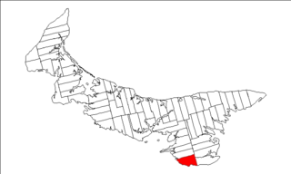
Cardigan is a federal electoral district in Prince Edward Island, Canada, that has been represented in the House of Commons of Canada since 1968.

Red Bay is a fishing village in Labrador, notable as one of the most precious underwater archaeological sites in the Americas. Between 1530 and the early 17th century, it was a major Basque whaling area. Several whaling ships, both large galleons and small chalupas, sank there, and their discovery led to the designation of Red Bay in 2013 as a UNESCO World Heritage Site.
Borden Island is an uninhabited, low-lying island in the Queen Elizabeth Islands of northern Canada.

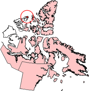
Brock Island is one of the uninhabited islands of the Canadian Arctic Archipelago located in the Northwest Territories, Canada. Located at 77°51'N 114°27'W, it measures 764 km2 (295 sq mi) in size and lies close to Mackenzie King Island. The first known sighting of the island by a European was by Vilhjalmur Stefansson in 1915 and it was later named for Reginald W. Brock, Dean of Applied Science at the University of British Columbia.

Durham is a federal electoral district in Ontario, Canada, that has been represented in the House of Commons of Canada from 1904 to 1968, and since 1988.

Thetis Island is an island and unincorporated community off the coast of British Columbia, Canada, lying between Vancouver Island, which is to the west across Stuart Channel, and the west from the north tip of Galiano Island, from which it is separated by Trincomali Channel. With its immediate southern neighbour Penelakut Island, it is one of the Gulf Islands. Thetis island is 2,560 acres (1,036 ha) in size. It is approximately two miles wide and three miles long north to south. Two north to south land ridges define the east and west sides of the island. Burchell Hill is 591 feetabove sea level, and forms the high point on the west side of Thetis island, and Moore Hill is 585 feet above sea level, and forms the high point ridge on the east side of the island.

UTC−03:00 is an identifier for a time offset from UTC of −03:00.

The Niut Range is 3600 km² in area. It is a subrange of the Pacific Ranges of the Coast Mountains of British Columbia, although in some classifications it is considered part of the Chilcotin Ranges. The Niut is located in the angle of the Homathko River and its main west fork, Mosley Creek. It is isolated, island-like, by those rivers from its neighbour ranges, as both streams have their source on the Chilcotin Plateau in behind the range. Razorback Mountain is its highest peak.
Lot 62 is a township in Queens County, Prince Edward Island, part of St. John's Parish. Lot 62 was awarded to Richard Spry, Esquire in the 1767 Land Lottery, and came to be settled through the efforts of Thomas Douglas, The 5th Earl of Selkirk in 1803. Richard Spry, Esquire, was then Commodore, Commander-in-Chief, Mediterranean Fleet at Gibraltar 1766–1769. Becoming the proprietor, he would be familiar with then the Island of St. John, having first come out to North America in 1754, with the English naval blockade of Ile Royal and the Fortress of Louisbourg in 1756, and then serving off Quebec and in the St. Lawrence into 1759. In 1762, he returned as Commander-in-Chief, North America, quartered in Halifax.

St. George's Parish was created as a civil parish in Kings County, Prince Edward Island, Canada, during the 1764-1766 survey of Samuel Holland.
North Thompson Islands Provincial Park is a provincial park in British Columbia, Canada.
The uninhabited Plover Islands are an archipelago, members of the Canadian Arctic Archipelago and the Ungava Bay Archipelago, in the Qikiqtaaluk Region of Nunavut, Canada. They are located in western Ungava Bay, just northeast of the Arnaud River and the community of Kangirsuk on Quebec's Ungava Peninsula.
The uninhabited Payne Islands are an archipelago, members of the Canadian Arctic Archipelago and the Ungava Bay Archipelago, in the Qikiqtaaluk Region of Nunavut, Canada. They are located in Payne Bay, a waterway in western Ungava Bay, just east of the Arnaud River and the community of Kangirsuk on Quebec's Ungava Peninsula.
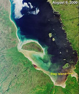
Stag Island is an uninhabited island in the southern part of James Bay, in the Qikiqtaaluk Region of Nunavut, Canada. Located at 51°39′01″N79°04′28″W, it is the southernmost island and point of land in Nunavut.

The Municipality of Lot 11 and Area is a municipality that holds community status in Prince Edward Island, Canada. It is located within Prince County.

Resort Municipality, officially named the Resort Municipality of Stanley Bridge, Hope River, Bayview, Cavendish and North Rustico, is the lone municipality in Prince Edward Island, Canada that holds resort municipality status. It was established in 1990.
Long River is an unincorporated community, in Queens County. Long River is in Lot 20 of Statistics Canada
