Lot 66, Prince Edward Island

Last updated
Lot 66, Prince Edward Island
Township
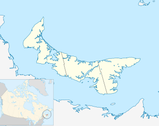
Map of Prince Edward Island highlighting Lot 66.png
Map of Prince Edward Island highlighting Lot 66
Coordinates: 46°12′N62°45′W / 46.200°N 62.750°W / 46.200; -62.750 Coordinates: 46°12′N62°45′W / 46.200°N 62.750°W / 46.200; -62.750
Country Canada
Province Prince Edward Island
County Kings County
Parish St. George's Parish
Area
  Total 35.07 sq mi (90.83 km2)
Population (2006)
  Total 847
  Density 24/sq mi (9.3/km2)
Time zone AST (UTC-4)
  Summer (DST) ADT (UTC-3)
Canadian Postal code C0A
Area code(s) 902
NTS Map 011L02
GNBC Code BAETA

Lot 66 is a township in Kings County, Prince Edward Island, Canada. It is part of St. George's Parish. Lot 66 was not distributed in the 1767 land lottery, but was reserved as demesne lands of the Crown. [1]

Kings County, Prince Edward Island Place

Kings County is located in eastern Prince Edward Island, Canada.
Prince Edward Island Province of Canada

Prince Edward Island is a province of Canada consisting of the Atlantic island of the same name along with several much smaller islands nearby. PEI is one of the three Maritime Provinces. It is the smallest province of Canada in both land area and population, but it is the most densely populated. Part of the traditional lands of the Mi'kmaq, it became a British colony in the 1700s and was federated into Canada as a province in 1873. Its capital is Charlottetown. According to the 2016 census, the province of PEI has 142,907 residents.

Canada Country in North America

Canada is a country in the northern part of North America. Its ten provinces and three territories extend from the Atlantic to the Pacific and northward into the Arctic Ocean, covering 9.98 million square kilometres, making it the world's second-largest country by total area. Canada's southern border with the United States is the world's longest bi-national land border. Its capital is Ottawa, and its three largest metropolitan areas are Toronto, Montreal, and Vancouver. As a whole, Canada is sparsely populated, the majority of its land area being dominated by forest and tundra. Consequently, its population is highly urbanized, with over 80 percent of its inhabitants concentrated in large and medium-sized cities, many near the southern border. Canada's climate varies widely across its vast area, ranging from arctic weather in the north, to hot summers in the southern regions, with four distinct seasons.

Related Research Articles

Gentofte Municipality Municipality in Capital Region, Denmark

Gentofte Kommune is a municipality in the Capital Region of Denmark on the east coast of the island of Zealand (Sjælland) in eastern Denmark. It covers an area of 25.54 km2 (9.86 sq mi), and has a total population of 74,548. Since 1993, its mayor has been Hans Toft, a member of the Conservative People's Party.

Burano island

Burano is an island in the Venetian Lagoon, northern Italy, near Torcello at the northern end of the Lagoon, known for its lace work and brightly coloured homes. The primary economy is tourism.

East Falls Church station Washington Metro station in Arlington County, VA on the Orange and Silver lines

East Falls Church is an island-platformed Washington Metro station in Arlington, Virginia on the Orange and Silver Lines. East Falls Church station is the last aboveground, at grade, or open cut station for eastbound trains. East of this station, the trains heading toward downtown DC descends underground, therefore leaving the median of I-66 and entering subway mode.

Penelakut Island Island in British Columbia, Canada

Penelakut Island, formerly known as Kuper Island and renamed in 2010 in honour of the Penelakut First Nation people, is located in the southern Gulf Islands between Vancouver Island and the mainland Pacific coast of British Columbia, Canada. The island has a population of about 300 members of the Penelakut Band. The island has an area of 8.66 square kilometres (3.34 sq mi). There is frequent car and passenger ferry service to Penelakut from Chemainus on Vancouver Island.

Greater Montreal Metropolitan area in Quebec, Canada

Greater Montreal is the most populous metropolitan area in Quebec, and the second most populous in Canada after Greater Toronto. In 2015, Statistics Canada identified Montreal's Census Metropolitan Area (CMA) as 4,258.31 square kilometres (1,644.14 sq mi) with a population of 4,027,100.

Murter island

Murter is an island in the Croatian part of the Adriatic Sea.

Kingsclear Parish, New Brunswick Parish in New Brunswick, Canada

Kingsclear is a Canadian parish in York County, New Brunswick.

Scott Glacier (East Antarctica) glacier in Antarctica

Scott Glacier is a glacier, 7 miles (11.3 km) wide and over 20 miles (32 km) long, flowing north-northwest to the Antarctic coast between Denman Glacier and Mill Island. It was discovered by the Western Base Party of the Australasian Antarctic Expedition (1911-1914) under Mawson and named for Capt. Robert F. Scott.

Denman Glacier glacier in Antarctica

Denman Glacier is a glacier 7 to 10 nautical miles wide, descending north some 70 nautical miles, which debouches into the Shackleton Ice Shelf east of David Island, Queen Mary Land. It was discovered in November 1912 by the Western Base party of the Australasian Antarctic Expedition under Sir Douglas Mawson. Mawson named the glacier for Lord Denman, Governor-General of Australia in 1911, a patron of the expedition.

The French Antarctic Expedition is any of several French expeditions in Antarctica.

St. Georges Parish, Prince Edward Island

St. George's Parish was created as a civil parish in Kings County, Prince Edward Island, Canada, during the 1764-1766 survey of Samuel Holland.

Baba Bhit Island is the smallest neighbourhood of Kiamari Town in Karachi, Sindh, Pakistan. It comprises three small fishing islands which are in the centre of the harbour of Karachi. The approximated area of these islands is 4 km² and the population is about 12000. The area is severely neglected by the local and the central government because of its separation from the mainland

Murray Harbour, Prince Edward Island Community in Prince Edward Island, Canada

Murray Harbour is a municipality that holds rural municipality status in Prince Edward Island, Canada. It is located in southeastern Kings County.

Dalhousie Parish, New Brunswick Parish in New Brunswick, Canada

Dalhousie is a Canadian parish in Restigouche County, New Brunswick.

Douglas Parish, New Brunswick Parish in New Brunswick, Canada

Douglas is a Canadian parish in York County, New Brunswick.

Delhi, Wisconsin Ghost Town in Wisconsin, United States

Delhi, Wisconsin is a ghost town in the town of Rushford, Winnebago County, Wisconsin, United States. It is located on County Highway E between Omro and Eureka at the junction of the Fox River and Waukau Creek. Delhi was also known as La Borde's Landing. 1980 census records identify Delhi as Island Park. Delhi had an established post office between 1850-1893.

Cambridge Parish, New Brunswick Parish in New Brunswick, Canada

Cambridge is a Canadian parish in Queens County, New Brunswick.

Westfield Parish, New Brunswick Parish in New Brunswick, Canada

Westfield is a civil parish in Kings County, New Brunswick.

The 1965–66 Coppa Italia, the 19th Coppa Italia, was an Italian Football Federation domestic cup competition won by Fiorentina.

References

  1. Clark, Andrew Hill (1959). Three Centuries and the Island. Toronto Press. pp. Appendix B.