Lot 3, Prince Edward Island

Last updated
Lot 3, Prince Edward Island
Township
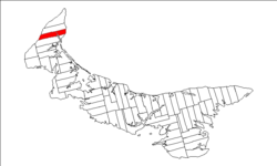
Map of Prince Edward Island highlighting Lot 3.png
Map of Prince Edward Island highlighting Lot 3
Coordinates: 46°53′N64°7′W / 46.883°N 64.117°W / 46.883; -64.117 Coordinates: 46°53′N64°7′W / 46.883°N 64.117°W / 46.883; -64.117
Country Canada
Province Prince Edward Island
County Prince County
Parish North Parish
Area
  Total 86.81 km2 (33.52 sq mi)
Population (2006)
  Total 899
  Density 10.4/km2 (27/sq mi)
Time zone AST (UTC-4)
  Summer (DST) ADT (UTC-3)
Canadian Postal code C0B
Area code(s) 902
NTS Map 021I16
GNBC Code BAEQP

Lot 3 is a township in Prince County, Prince Edward Island, Canada created during the 17641766 survey of Samuel Holland. It is part of North Parish.

Prince County, Prince Edward Island Place

Prince County is located in western Prince Edward Island, Canada. The county's defining geographic feature is Malpeque Bay, a sub-basin of the Gulf of St. Lawrence, which creates the narrowest portion of Prince Edward Island's landmass, an isthmus upon which the city of Summerside is located.

Prince Edward Island Province of Canada

Prince Edward Island is a province of Canada consisting of the Atlantic island of the same name along with several much smaller islands nearby. PEI is one of the three Maritime Provinces. It is the smallest province of Canada in both land area and population, but it is the most densely populated. Part of the traditional lands of the Mi'kmaq, it became a British colony in the 1700s and was federated into Canada as a province in 1873. Its capital is Charlottetown. According to the 2016 census, the province of PEI has 142,907 residents.

Canada Country in North America

Canada is a country in the northern part of North America. Its ten provinces and three territories extend from the Atlantic to the Pacific and northward into the Arctic Ocean, covering 9.98 million square kilometres, making it the world's second-largest country by total area. Canada's southern border with the United States is the world's longest bi-national land border. Its capital is Ottawa, and its three largest metropolitan areas are Toronto, Montreal, and Vancouver. As a whole, Canada is sparsely populated, the majority of its land area being dominated by forest and tundra. Consequently, its population is highly urbanized, with over 80 percent of its inhabitants concentrated in large and medium-sized cities, many near the southern border. Canada's climate varies widely across its vast area, ranging from arctic weather in the north, to hot summers in the southern regions, with four distinct seasons.

Contents

Population

Communities

Incorporated municipalities:

Civic address communities:

Alma, Prince Edward Island locality in Prince Edward Island

Alma is a settlement in Prince Edward Island.

Central Kildare, Prince Edward Island human settlement in Prince Edward Island, Canada

Central Kildare is a settlement in Prince Edward Island. It is located a few kilometres north of Alberton, Prince Edward Island.

Elmsdale, Prince Edward Island Place in Prince Edward Island, Canada

Elmsdale is a Canadian rural community located in western Prince County, Prince Edward Island.

History

The township went through various owners under feudalism when Prince Edward Island was a British colony prior to Canadian Confederation:

Feudalism combination of legal and military customs in medieval Europe

Feudalism was a combination of legal and military customs in medieval Europe that flourished between the 9th and 15th centuries. Broadly defined, it was a way of structuring society around relationships derived from the holding of land in exchange for service or labour. Although derived from the Latin word feodum or feudum (fief), then in use, the term feudalism and the system it describes were not conceived of as a formal political system by the people living in the Middle Ages. In its classic definition, by François-Louis Ganshof (1944), feudalism describes a set of reciprocal legal and military obligations among the warrior nobility revolving around the three key concepts of lords, vassals and fiefs.

Canadian Confederation process by which the British colonies of Canada, Nova Scotia, and New Brunswick were united into one Dominion of Canada on July 1, 1867

Canadian Confederation was the process by which the British colonies of Canada, Nova Scotia, and New Brunswick were united into one Dominion of Canada on July 1, 1867. Upon confederation, the old province of Canada was divided into Ontario and Quebec; along with Nova Scotia and New Brunswick, the new federation thus comprised four provinces. Over the years since Confederation, Canada has seen numerous territorial changes and expansions, resulting in the current union of ten provinces and three territories.


Related Research Articles

Prince Edward County, Ontario City in Ontario, Canada

Prince Edward County is a single-tier municipality and a census division of the Canadian province of Ontario.

Kingston and the Islands Federal electoral district

Kingston and the Islands is a federal electoral district in Ontario, Canada, that has been represented in the House of Commons of Canada since 1968.

Greenmount may refer to:

Lot 1, Prince Edward Island Township in Prince Edward Island, Canada

Lot 1 is a township in Prince County, Prince Edward Island, Canada created during the 1764–1766 survey of Samuel Holland. It is part of North Parish.

Lot 60, Prince Edward Island Township in Prince Edward Island, Canada

Lot 60 is a township in Queens County, Prince Edward Island, Canada. It is part of St. John's Parish. In the 1767 land lottery, Lot 60 was awarded to Major John Wrightson and Captain Daniel Shaw of the 42nd Regiment of Foot.

Lot 2, Prince Edward Island Township in Prince Edward Island, Canada

Lot 2 is a township in Prince County, Prince Edward Island, Canada created during the 1764–1766 survey of Samuel Holland. It is part of North Parish.

Lot 4, Prince Edward Island Township in Prince Edward Island, Canada

Lot 4 is a township in Prince County, Prince Edward Island, Canada created during the 1764–1766 survey of Samuel Holland. It is part of Egmont Parish.

St. Felix is a municipality that holds community status in Prince Edward Island, Canada. It is located in Prince County, 4 km (2.5 mi) south of Tignish.

Alberton, Prince Edward Island Town in Prince Edward Island, Canada

Alberton is a Canadian town located in Prince County, Prince Edward Island. It is situated in the western part of the county in the township of Lot 5. The population was 1,149 as of the 2016 census.

Ascension Road, labelled Route 160, is a 2-lane collector highway in western Prince County, Prince Edward Island, Canada. It is located 2 miles (3.2 km) NW of the community of Tignish. Its maximum speed limit is 80 kilometres per hour (50 mph).

Pridham Road, labelled Route 154, is a 2-lane collector highway in western Prince County, Prince Edward Island, Canada. It is near the town of Alberton. Its maximum speed limit is 80 km/h (50 mph).

Greenmount Road, labelled Route 153, is a 2-lane collector highway in western Prince County, Prince Edward Island, Canada. It is between the communities of Tignish and Alberton. Its maximum speed limit is 90 km/h (56 mph). The road is considered part of two larger communities, Tignish and Alberton.

Alberton-Roseville Provincial electoral district in Prince Edward Island

Alberton-Roseville is a provincial electoral district for the Legislative Assembly of Prince Edward Island, Canada. It was formerly known as Alberton-Miminegash from 1996 to 2007.

Tignish-Palmer Road Provincial electoral district in Prince Edward Island

Tignish-Palmer Road is a provincial electoral district for the Legislative Assembly of Prince Edward Island, Canada. It was formerly Tignish-DeBlois from 1996 to 2007.

Charlottetown Provincial capital city in Prince Edward Island, Canada

Charlottetown is the capital and largest city of the Canadian province of Prince Edward Island, and the county seat of Queens County. Named after Charlotte of Mecklenburg-Strelitz, queen consort of King George III of the United Kingdom, Charlottetown was originally an unincorporated town that incorporated as a city in 1855.

Greenmount-Montrose

Greenmount is a municipality that holds community status in Prince Edward Island, Canada.