Brackley, Prince Edward Island

Last updated

Brackley
Rural Municipality of Brackley
Canada Prince Edward Island location map 2.svg
Red pog.svg
Brackley in Prince Edward Island
Coordinates: 46°17′52.3″N63°8′31.3″W / 46.297861°N 63.142028°W / 46.297861; -63.142028
CountryCanada
Province Prince Edward Island
County Queens County
Incorporated1983
Amalgamated [1] December 15, 2017
Rural municipality December 23, 2017
Population
 (2021) [2]
  Total586
Time zone AST
  Summer (DST) ADT
Area code 902
Website http://brackleypei.ca

Brackley is a rural municipality in Prince Edward Island, Canada. It is located on the northern boundary of Charlottetown, adjoining the Charlottetown Airport that is in the neighbourhood of Sherwood.[ citation needed ] Brackley originally incorporated in 1983. It absorbed the adjacent former municipality of Winsloe South via amalgamation on December 15, 2017. [1]

Demographics

Federal census population history of Brackley (pre-amalgamation)
YearPop.±%
1981295    
1986306+3.7%
1991 327+6.9%
1996 367+12.2%
2001 358−2.5%
2006 336−6.1%
2011 340+1.2%
2016 372+9.4%
Source: Statistics Canada
[3] [4] [5] [6] [7] [8] [2]
Federal census population history of Brackley (post-amalgamation)
YearPop.±%
2016 596    
2021 586−1.7%
Source: Statistics Canada [9]

In the 2021 Census of Population conducted by Statistics Canada, Brackley had a population of 586 living in 234 of its 240 total private dwellings, a change of

Related Research Articles

<span class="mw-page-title-main">Stratford, Prince Edward Island</span> Town in Prince Edward Island, Canada

Stratford is a town located in Queens County, Prince Edward Island.

<span class="mw-page-title-main">Summerside, Prince Edward Island</span> City in Prince Edward Island, Canada

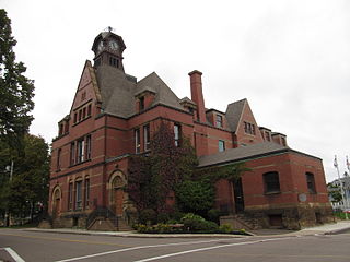
Summerside is a Canadian city in Prince County, Prince Edward Island. It is the second largest city in the province and the primary service centre for the western part of the island.

<span class="mw-page-title-main">Cornwall, Prince Edward Island</span> Town in Prince Edward Island, Canada

Cornwall is a Canadian town located in Queens County, Prince Edward Island. The town is located immediately west of the provincial capital Charlottetown.

<span class="mw-page-title-main">Tignish, Prince Edward Island</span> Town in Prince Edward Island, Canada

Tignish is a Canadian town located in Prince County, Prince Edward Island.

Union Road is a rural municipality in Prince Edward Island, Canada. It is located in Queens County.

<span class="mw-page-title-main">Georgetown, Prince Edward Island</span> Place in Prince Edward Island, Canada

Georgetown is a community located within the municipality of Three Rivers in Kings County, Prince Edward Island, Canada. It is the Capital of Kings County. Previously incorporated as a town, it amalgamated with the town of Montague, the rural municipalities of Brudenell, Cardigan, Lorne Valley, Lower Montague, and Valleyfield, and portions of three adjacent unincorporated areas in 2018.

Mount Stewart is a rural municipality in Prince Edward Island, Canada. It is located in the northeastern part of Queens County, at the head of the once-navigable portion of the Hillsborough River at the point where the river begins to narrow significantly. Mount Stewart had a population of 226 at the time of the 2021 Census.

Abram-Village is a rural municipality in Prince County, Prince Edward Island, Canada.

Victoria is a rural municipality in Prince Edward Island, Canada. A historic seaport, the community is situated at the extreme southwestern edge of Queens County in the township of Lot 29.

St. Louis is a municipality that holds community status in Prince Edward Island, Canada.

<span class="mw-page-title-main">Charlottetown</span> Capital city of Prince Edward Island, Canada

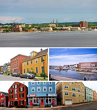
Charlottetown is the capital and largest city of the Canadian province of Prince Edward Island, and the county seat of Queens County. Named after Queen Charlotte, Charlottetown was an unincorporated town until it was incorporated as a city in 1855.

Bedeque is a former municipality that previously held community status in the Canadian province of Prince Edward Island. It was dissolved through its amalgamation with the Community of Central Bedeque on November 17, 2014 to create the Community of Bedeque and Area.

Kinkora is a rural municipality in Prince Edward Island, Canada.

Meadowbank, previously Meadow Bank, is a former rural municipality in the Canadian province of Prince Edward Island within Queens County.

<span class="mw-page-title-main">Resort Municipality, Prince Edward Island</span> Resort municipality in Prince Edward Island, Canada

Resort Municipality, officially named the Resort Municipality of Stanley Bridge, Hope River, Bayview, Cavendish and North Rustico, is the lone municipality in Prince Edward Island, Canada that holds resort municipality status. It was established in 1990.

St. Peters Bay is a municipality that holds community status in Prince Edward Island, Canada. It was incorporated in 1953. St. Peters Bay is well known for its annual Blueberry Festival and Parade, which draws in tourists and locals alike.

Miltonvale Park is a municipality that holds community status in Prince Edward Island, Canada. It was incorporated in 1974.

Winsloe South is a former municipality in Prince Edward Island, Canada that held community status between 1986 and 2017. It amalgamated with Brackley on December 15, 2017.

Central Prince is a rural municipality within Prince County in Prince Edward Island that was incorporated on September 28, 2018 through an amalgamation of two municipalities. The municipalities that amalgamated were the rural municipalities of Ellerslie-Bideford and Lady Slipper.

References

  1. 1 2 "EC2017-746 (Municipalities Act: Community of Brackley and Community of Winsloe South Amalgamation" (PDF). Government of Prince Edward Island, Executive Council. December 12, 2017. pp. 5–6. Retrieved December 26, 2017.
  2. 1 2 "Population and dwelling counts, for Canada, provinces and territories, and census subdivisions (municipalities), 2016 and 2011 censuses – 100% data (Prince Edward Island)". Statistics Canada. February 8, 2017. Retrieved February 2, 2022.
  3. "1986 Census: Population - Census Divisions and Census Subdivisions" (PDF). Statistics Canada. September 1987. Retrieved February 2, 2022.
  4. "91 Census: Census Divisions and Census Subdivisions - Population and Dwelling Counts" (PDF). Statistics Canada. April 1992. Retrieved February 2, 2022.
  5. "96 Census: A National Overview - Population and Dwelling Counts" (PDF). Statistics Canada. April 1997. Retrieved February 2, 2022.
  6. "Population and Dwelling Counts, for Canada, Provinces and Territories, and Census Subdivisions (Municipalities), 2001 and 1996 Censuses - 100% Data (Prince Edward Island)". Statistics Canada. August 15, 2012. Retrieved February 2, 2022.
  7. "Population and dwelling counts, for Canada, provinces and territories, and census subdivisions (municipalities), 2006 and 2001 censuses - 100% data (Prince Edward Island)". Statistics Canada. August 20, 2021. Retrieved February 2, 2022.
  8. "Population and dwelling counts, for Canada, provinces and territories, and census subdivisions (municipalities), 2011 and 2006 censuses (Prince Edward Island)". Statistics Canada. July 25, 2021. Retrieved February 2, 2022.
  9. 1 2 "Population and dwelling counts: Canada, provinces and territories, and census subdivisions (municipalities), Prince Edward Island". Statistics Canada. February 9, 2022. Retrieved March 3, 2022.