Miscouche

Last updated

Miscouche
MiscoucheChurch.jpg
St. John the Baptist Church, erected in 1892
Canada Prince Edward Island location map 2.svg
Red pog.svg
Miscouche
Canada location map 2.svg
Red pog.svg
Miscouche
North America laea location map.svg
Red pog.svg
Miscouche
Coordinates: 46°25′57″N63°52′06″W / 46.43260°N 63.86825°W / 46.43260; -63.86825
CountryCanada
Province Prince Edward Island
County Prince County
Time zone UTC-4 (Atlantic (AST))
  Summer (DST) UTC-3 (ADT)
Postal code
Area code 902
Website miscouche.ca

Miscouche (2021 population: 992) is a municipality that holds community status in Prince Edward Island, Canada. [1] It is located in Prince County.

Contents

Incorporated in 1957, Miscouche is located 10 kilometres west of the City of Summerside. Its name is derived from the Mi'kmaq term for "Little grassy island".

Miscouche is east to the Evangeline Region, the province's largest francophone area comprising numerous Acadian settlements; 15% of Miscouche's population is considered francophone. Miscouche also serves as a service centre for some nearby rural communities, including Belmont, Central Lot 16, Southwest Lot 16, Grand River, St. Nicolas, and Linkletter.

Poster for the Second Acadian National Convention, held in Miscouche in August 1884 Conventions 4.jpg
Poster for the Second Acadian National Convention, held in Miscouche in August 1884

History

The Second Acadian National Convention was held in Miscouche in 1884, and was attended by approximately 5,000 Acadian delegates from across the Maritimes. The Convention saw the adoption of nearly all Acadian national symbols, including the Acadian flag. Because Miscouche hosted this historic convention, it was decided in 1964 that the Acadian Museum of Prince Edward Island be constructed next to the church. The Museum has been housed in a much larger facility since 1991 (still located on the same location as the former museum) and since 1996 it has served as one of the seven sites of Museum & Heritage Prince Edward Island, a division of the provincial Department of Community, Cultural Affairs and Labour.

St. John the Baptist Roman Catholic Church is one of the oldest wooden churches in Prince Edward Island. It features a historic Casavant organ. Extensive renovations were completed in recent years to restore much of the previous grandeur of the building.

Demographics

Federal census population history of Miscouche
YearPop.±%
1961676    
1966729+7.8%
1971750+2.9%
1976748−0.3%
1981752+0.5%
1986677−10.0%
1991 672−0.7%
1996 679+1.0%
2001 766+12.8%
2006 769+0.4%
2011 869+13.0%
2016 873+0.5%
2021 992+13.6%
Source: Statistics Canada
[2] [3] [4] [5] [6] [7] [8] [9] [10] [11] [12] [13]

In the 2021 Census of Population conducted by Statistics Canada, Miscouche had a population of 992 living in 386 of its 401 total private dwellings, a change of

Education

Miscouche Consolidated School was established in 1977. Grades Kindergarten through 9 are taught, with grades 10 -12 taught at Three Oaks Senior High in Summerside.

Related Research Articles

<span class="mw-page-title-main">Summerside, Prince Edward Island</span> City in Prince Edward Island, Canada

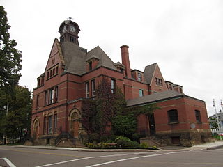
Summerside is a Canadian city in Prince County, Prince Edward Island. It is the second largest city in the province and the primary service centre for the western part of the island.

<span class="mw-page-title-main">Tignish, Prince Edward Island</span> Town in Prince Edward Island, Canada

Tignish is a Canadian town located in Prince County, Prince Edward Island.

<span class="mw-page-title-main">Souris, Prince Edward Island</span> Town in Prince Edward Island, Canada

Souris is a town in Kings County, Prince Edward Island, Canada. It is located near the northeastern tip of the province.

<span class="mw-page-title-main">North Rustico</span> Town in Prince Edward Island, Canada

North Rustico is a Canadian town located in Queens County, Prince Edward Island.

Alberton is a Canadian town located in Prince County, Prince Edward Island. It is situated in the western part of the county in the township of Lot 5.

<span class="mw-page-title-main">Kensington, Prince Edward Island</span> Town in Prince Edward Island, Canada

Kensington is a Canadian town located in Prince County, Prince Edward Island. It is 15 km (9.3 mi) northeast of the city of Summerside. In 2021, its population was 1,812.

<span class="mw-page-title-main">Georgetown, Prince Edward Island</span> Place in Prince Edward Island, Canada

Georgetown is a community located within the municipality of Three Rivers in Kings County, Prince Edward Island, Canada. It is the Capital of Kings County. Previously incorporated as a town, it amalgamated with the town of Montague, the rural municipalities of Brudenell, Cardigan, Lorne Valley, Lower Montague, and Valleyfield, and portions of three adjacent unincorporated areas in 2018.

O'Leary is a town located in Prince County, Prince Edward Island. Its population in the 2016 Census was 815 people.

Brackley is a rural municipality in Prince Edward Island, Canada. It is located on the northern boundary of Charlottetown, adjoining the Charlottetown Airport that is in the neighbourhood of Sherwood. Brackley originally incorporated in 1983. It absorbed the adjacent former municipality of Winsloe South via amalgamation on December 15, 2017.

Miminegash is a rural municipality in Prince Edward Island, Canada. It is located 8 miles (13 km) northwest of Alberton and 11 miles (18 km) southwest of Tignish. It is part of a small area in Lot 3 known as either the St. Louis, Palmer Road, or Miminegash area. This area is often associated with Tignish due to the shared Acadian roots between these areas.

Murray River is a rural municipality in Prince Edward Island, Canada. It is located in Kings County.

Wellington is a rural municipality in Prince Edward Island, Canada. It is located in Prince County, and extends as Wellington Centre onto Route 2 from Richmond through to St. Nicholas.

Abram-Village is a rural municipality in Prince County, Prince Edward Island, Canada.

Victoria is a rural municipality in Prince Edward Island, Canada. A historic seaport, the community is situated at the extreme southwestern edge of Queens County in the township of Lot 29.

<span class="mw-page-title-main">Cardigan, Prince Edward Island</span> Municipality in Prince Edward Island

Cardigan was a municipality that held community status in Prince Edward Island, Canada. It was a fishing community in eastern Kings County.

Kinkora is a rural municipality in Prince Edward Island, Canada.

Linkletter is a rural municipality in Prince Edward Island, Canada. It is located in Prince County.

The Municipality of Malpeque Bay is a municipality that holds community status in Prince Edward Island, Canada. It is located in Prince County and Queens County.

Sherbrooke is a rural municipality in Prince Edward Island, Canada.

Warren Grove is a municipality that holds community status in Prince Edward Island, Canada. It was incorporated in 1985.

References

  1. "Municipal Councils and Contact Information" (PDF). Government of Prince Edward Island. January 27, 2017. Retrieved February 4, 2017.
  2. "Table 6: Population by census subdivisions, 1901–1961". 1961 Census of Canada (PDF). Series 1.1: Historical, 1901–1961. Vol. I: Population. Ottawa: Dominion Bureau of Statistics. March 8, 1963. Retrieved February 2, 2022.
  3. "Table 2: Population of Census Subdivisions, 1921–1971". 1971 Census of Canada (PDF). Population. Vol. Census Subdivisions (Historical). Ottawa: Statistics Canada. July 1973. Retrieved February 2, 2022.
  4. "1976 Census of Canada: Population - Geographic Distributions" (PDF). Statistics Canada. June 1977. Retrieved February 2, 2022.
  5. "1981 Census of Canada: Census subdivisions in decreasing population order" (PDF). Statistics Canada. May 1992. Retrieved February 2, 2021.
  6. "1986 Census: Population - Census Divisions and Census Subdivisions" (PDF). Statistics Canada. September 1987. Retrieved February 2, 2022.
  7. "91 Census: Census Divisions and Census Subdivisions - Population and Dwelling Counts" (PDF). Statistics Canada. April 1992. Retrieved February 2, 2022.
  8. "96 Census: A National Overview - Population and Dwelling Counts" (PDF). Statistics Canada. April 1997. Retrieved February 2, 2022.
  9. "Population and Dwelling Counts, for Canada, Provinces and Territories, and Census Subdivisions (Municipalities), 2001 and 1996 Censuses - 100% Data (Prince Edward Island)". Statistics Canada. August 15, 2012. Retrieved February 2, 2022.
  10. "Population and dwelling counts, for Canada, provinces and territories, and census subdivisions (municipalities), 2006 and 2001 censuses - 100% data (Prince Edward Island)". Statistics Canada. August 20, 2021. Retrieved February 2, 2022.
  11. "Population and dwelling counts, for Canada, provinces and territories, and census subdivisions (municipalities), 2011 and 2006 censuses (Prince Edward Island)". Statistics Canada. July 25, 2021. Retrieved February 2, 2022.
  12. "Population and dwelling counts, for Canada, provinces and territories, and census subdivisions (municipalities), 2016 and 2011 censuses – 100% data (Prince Edward Island)". Statistics Canada. February 8, 2017. Retrieved February 2, 2022.
  13. 1 2 "Population and dwelling counts: Canada, provinces and territories, and census subdivisions (municipalities), Prince Edward Island". Statistics Canada. February 9, 2022. Retrieved March 3, 2022.

Coordinates: 46°25′57.54″N63°52′4.14″W / 46.4326500°N 63.8678167°W / 46.4326500; -63.8678167