
Location of Freeland in Prince Edward Island
Freeland is a Canadian rural community in Prince County, Prince Edward Island. [1]
It is located in the township of Lot 11, [2] north of Ellerslie. [3]
Freeland is a Canadian rural community in Prince County, Prince Edward Island. [1]
It is located in the township of Lot 11, [2] north of Ellerslie. [3]

Cape Tormentine is a rural community and former local service district in southeastern New Brunswick, Canada. It is located on the Northumberland Strait at the Abegweit Passage, the shortest crossing between Prince Edward Island and the mainland. It once flourished as a transportation hub between New Brunswick and Prince Edward Island but has been in decline since 1997 when the ferry service was closed due to the opening of the Confederation Bridge. At the Canada 2011 Census the population was 108, three quarters what it was at the 2006 census.

Cavendish is an unincorporated rural community in the township of Lot 23, Queens County, Prince Edward Island, Canada.

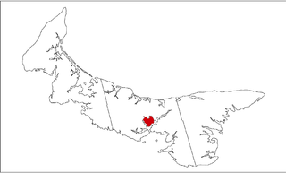
Kensington-Malpeque is a provincial electoral district for the Legislative Assembly of Prince Edward Island, Canada.

Green Park Provincial Park is a provincial park in Prince Edward Island, Canada. It is located on the western shore of Malpeque Bay. It is the site of a former shipyard; in the 19th century, ship building was a major industry on Prince Edward Island. The province acquired the land in the 1960s. It is home to the Green Park Shipbuilding Museum and Yeo House, the historic home of a shipping magnate.

Argyle Shore Provincial Park is a provincial park on Prince Edward Island, Canada. It opened in 1961 and is 9.59 ha. The park's name comes from the area's early 19th-century settlers from Argyle Shire, Scotland.
Belmont is a Canadian rural farming community located in the larger community of Lot 16 in central Prince County, Prince Edward Island. Lot 16 is actually three communities: Belmont, Central, and Southwest Lot 16, and is one of the last communities on Prince Edward Island to continue using their lot designation from the original Island survey by Samuel Holland in the 18th century.
Tracadie is a Canadian rural community in Queens County, Prince Edward Island. It is located southwest of Mount Stewart. The name Tracadie, which is of Mi'kmaq origin, means "ideal camping location" and is pronounced tǔlakǎdǐk.
Coleman is a Canadian rural community in Prince County, Prince Edward Island.
Sherwood is a neighbourhood of the city of Charlottetown in central Queens County, Prince Edward Island, Canada.
Ellerslie Road, labelled Route 133, is a 2-lane collector highway in Prince County, Prince Edward Island, Canada. It is located 4.0–8.0 kilometres (2.5–5 mi) northeast of the community of Tyne Valley and is located within the community of Ellerslie. Its maximum speed limit is 80 km/h (50 mph).
USS Deperm (ADG-10) was a degaussing vessel of the United States Navy, named after the term deperm, a procedure for erasing the permanent magnetism from ships and submarines to camouflage them against magnetic detection vessels and enemy marine mines. Originally planned as a patrol craft escort (PCE-883), she was laid down in 1943, launched in 1944, and commissioned in 1945. She was subsequently redesignated a degaussing vessel, YDG-10, and named Deperm.

Fortune Bridge is a small unincorporated area on Lot 43, East Parish, King County, Prince Edward Island, Canada. It is located west of the Town of Souris.
Mount Pleasant is a Canadian rural community located in Prince County, Prince Edward Island.
Green Bay is a locality in the community of Kingston, Prince Edward Island. Green Bay falls inside the subdivision of Lot 30.
HMS Cooke (K471) was a British Captain-class frigate of the Royal Navy in commission during World War II. Originally constructed as the United States Navy Evarts-class destroyer escort USS Dempsey (DE-267), she served in the Royal Navy from 1943 to 1946.
The Cornwall Curling Club is a curling club in Cornwall, Prince Edward Island, Canada.

Rusticoville is an unincorporated rural community in the township of Lot 23, Queens County, Prince Edward Island, Canada.

South Rustico, formerly called Rustico, is an unincorporated rural community in the township of Lot 24, Queens County, Prince Edward Island, Canada.
Oyster Bed Bridge is an unincorporated rural community in the township of Lot 24, Queens County, Prince Edward Island, Canada.
Grand River is an unincorporated area in Prince Edward Island, Canada. It is located in Prince County, northeast of Wellington. It is named for the Grand River, which it is situated upon.
46°41′0″N63°58′0″W / 46.68333°N 63.96667°W
Subdivisions of Prince Edward Island | |||||||
|---|---|---|---|---|---|---|---|
| Subdivisions | |||||||
| Cities | |||||||
| Towns | |||||||
| Rural municipalities |
| ||||||
| Resort municipalities | |||||||
| Former municipalities |
| ||||||
| Unincorporated communities | |||||||
| | This Prince Edward Island location article is a stub. You can help Wikipedia by expanding it. |