King's Highway 33, commonly referred to as Highway 33 or Loyalist Parkway, is a provincially maintained highway in the Canadian province of Ontario. The route begins at Highway 62 in Bloomfield and travels east to the Collins Bay Road junction at Collins Bay in the city of Kingston, a distance of 60.9 kilometres (37.8 mi). The highway continues farther east into Kingston as Bath Road, ending at the former Highway 2, now Princess Street. Highway 33 is divided into two sections by the Bay of Quinte. The Glenora Ferry service crosses between the two sections just east of Picton, transporting vehicles and pedestrians for free throughout the year.
Canadian Forces Base Summerside was an air force base located in St. Eleanors, Prince Edward Island, Canada, now part of the city of Summerside.
Bonshaw is a former rural municipality in the Canadian province of Prince Edward Island within Queens County.
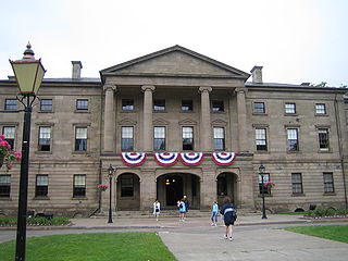
Province House is where the Prince Edward Island Legislature, known as the Legislative Assembly of Prince Edward Island, has met since 1847. The building is located at the intersection of Richmond and Great George Streets in Charlottetown; it is Canada's second-oldest seat of government.

Montague is a community within the Town of Three Rivers in Kings County, Prince Edward Island, Canada. Previously incorporated as a town, it amalgamated with the Town of Georgetown, the rural municipalities of Brudenell, Cardigan, Lorne Valley, Lower Montague, and Valleyfield, and portions of three adjacent unincorporated areas in 2018.

Highway 125 is a 28 km long controlled-access highway located in Nova Scotia's Cape Breton Regional Municipality. The provincial government named it Peacekeepers Way on August 18, 2008. Part of the provincial 100-series arterial highway network, Highway 125 encircles the west side of Sydney Harbour, from an interchange with Highway 105 at Sydney Mines to Trunk 4 immediately east of Sydney.
Route 1 is a 120-kilometre (75 mi) long provincial highway that serves as the Prince Edward Island section of the Trans-Canada Highway. Route 1 traverses the southern shores of Prince Edward Island, from the Confederation Bridge in Borden-Carleton to the Wood Islands ferry dock, and bypasses the provincial capital, Charlottetown. It is an uncontrolled access 2-lane highway with a maximum speed limit of 90 km/h (55 mph), except within towns and urban areas.
RCAF Station Charlottetown was a Royal Canadian Air Force station located in Sherwood, Prince Edward Island. Today's Charlottetown Airport maintains a remnant of the airfield's runways near its general aviation terminal, but all buildings and most infrastructure have been removed.

Argyle Shore Provincial Park is a provincial park on Prince Edward Island, Canada. It opened in 1961 and is 9.59 ha. The park's name comes from the area's early 19th-century settlers from Argyle Shire, Scotland.

Miscouche is a municipality that holds community status in Prince Edward Island, Canada. It is located in Prince County.
Belmont is a Canadian rural farming community located in the larger community of Lot 16 in central Prince County, Prince Edward Island. Lot 16 is actually three communities: Belmont, Central, and Southwest Lot 16, and is one of the last communities on Prince Edward Island to continue using their lot designation from the original Island survey by Samuel Holland in the 18th century.
Freeland is a Canadian rural community in Prince County, Prince Edward Island.

Route 2, also known as Veterans Memorial Highway and the All Weather Highway, is a 216-kilometre (134 mi) two-lane uncontrolled access highway traversing Prince Edward Island, Canada from Tignish to Souris. Route 2 was recognized as the first numbered highway in the province in 1890, when it opened between Charlottetown and Summerside.

General Holmes Drive is a 5-kilometre (3.1 mi) major divided road located in Sydney, New South Wales, Australia. The road forms part of the M1, the A1, the Sydney Orbital Network, and the Australian Highway 1 network. Initially built in 1919 as a two-lane road and duplicated in 1951, the road partially circumnavigates Sydney Airport with its north-eastern terminus in Mascot, heading west and then south and then south-west, with its south-western terminus with The Grand Parade in Brighton-Le-Sands.

The Hillsborough River Bridge is a bridge crossing the Hillsborough River estuary between Charlottetown and Stratford in Queens County, Prince Edward Island. The current road bridge, built in 1962, replaced a 1905 rail bridge crossing the same span which was known by the same name.
Kildare Capes is a settlement on Prince Edward Island, located within Canada's Prince County. Its earliest mapping is in the 1897 Map of Maritime Provinces of Canada.
Lady Slipper was a municipality that held community status in Prince Edward Island, Canada. On September 28, 2018, it was combined with the municipality of Ellerslie-Bideford, to create the new municipality of Central Prince.
West River is a rural municipality in the Canadian province of Prince Edward Island within Queens County.

Prince Edward Island Route 6 is a secondary highway in central Prince Edward Island.

Cane Beds is an unincorporated community and census-designated place (CDP) in Mohave County, Arizona, United States. It lies 4 miles (6 km) south of the border with Utah in the Arizona Strip, and is supported by services in Utah as well as some in Nevada.
