Ellerslie-Bideford, Prince Edward Island

Last updated

Ellerslie-Bideford
Municipality of Ellerslie-Bideford
Canada Prince Edward Island location map 2.svg
Red pog.svg
Ellerslie-Bideford in Prince Edward Island
Coordinates: 46°36′04″N63°57′29″W / 46.601°N 63.958°W / 46.601; -63.958
CountryCanada
Province Prince Edward Island
County Prince County
Parish Halifax
Lot Lot 12
Founded1901
Established1977
Government
  ChairpersonMyron Hutchinson
  CouncillorLorraine Barlow
Leslie Enman
Warren Gillis
Jason Grigg
Adam Hutchinson
Rod Millar
  CAOJulie Ellisworth-Enman
Population
 (2001)
  Total470
Time zone AST
  Summer (DST)ADT
Canadian postal code
C0B 1J0
Area code 902
NTS Map011L12
GNBC CodeBADWV

Ellerslie-Bideford was a municipality that held community status in Prince Edward Island, Canada. [1] It was located in Prince County on Lot 12.

Contents

Most residents of Ellerslie-Bideford lived on Ellerslie Road (Route 133) which spans 5 miles from Route 2 to Route 12.

History

The community was incorporated by provincial government in 1977, when Ellerslie merged with Bideford. Ellerslie was founded in 1853 by a local carpenter, being named after Ellerslie, Scotland. Bideford was named in 1818 after Bideford, Devon, England. [2] Ellerslie is currently one of the last communities in the West Prince district of Prince Edward Island prior to the border with East Prince.

Ellerslie Shellfish Station and Shellfish Museum. Situated on an arm of Malpeque Bay, it is a centre of the famed Malpeque Oyster industry. Ellerslie PE ShellfishStation 2013.jpg
Ellerslie Shellfish Station and Shellfish Museum. Situated on an arm of Malpeque Bay, it is a centre of the famed Malpeque Oyster industry.

The community had a rich history in the fox farming and ship building industries. The Bideford Shipyard launched several sea vessels, including the last one to be christened there, the Meteor. Bideford is also home to a Shellfish Museum; as the fishery is the basis of the local economy.

Over the past several years, the Community Improvement Council (or CIC) has endeavored to undertake several infrastructure projects. These projects include a new set of Soccer Fields and a Running Track. The Council also attempted to move the community towards a central sewer system from the current model of independent septic tanks for each dwelling, however this motion was defeated in a community vote, over much controversy.

On September 28, 2018, the municipality was combined with Lady Slipper, to create the new municipality of Central Prince. [3]

Education

Ellerslie was home to Ellerslie Elementary School, which has approximately 200 students in grades K-6. From this school, area residents go to Hernewood Intermediate, and Westisle Composite High.

Attractions

See also

Related Research Articles

<span class="mw-page-title-main">Summerside, Prince Edward Island</span> City in Prince Edward Island, Canada

Summerside is a Canadian city in Prince County, Prince Edward Island. It is the second largest city in the province and the primary service centre for the western part of the island.

<span class="mw-page-title-main">Montague, Prince Edward Island</span> Place in Prince Edward Island, Canada

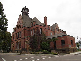
Montague is a community within the Town of Three Rivers in Kings County, Prince Edward Island, Canada. Previously incorporated as a town, it amalgamated with the Town of Georgetown, the rural municipalities of Brudenell, Cardigan, Lorne Valley, Lower Montague, and Valleyfield, and portions of three adjacent unincorporated areas in 2018.

<span class="mw-page-title-main">Lot 12, Prince Edward Island</span> Township in Prince Edward Island, Canada

Lot 12 is a township in Prince County, Prince Edward Island, Canada. It is part of Halifax Parish. Lot 12 was awarded to merchants Hutchinson Mure and Robert Cathcart in the 1767 land lottery, and by 1806 was partially owned by the Earl of Selkirk.

<span class="mw-page-title-main">Lot 13, Prince Edward Island</span> Township in Prince Edward Island, Canada

Lot 13 is a township in Prince County, Prince Edward Island, Canada. It is part of Richmond Parish. Lot 13 was awarded to John Pownall, Secretary to the Lords of Trade in the 1767 land lottery; and passed to the Marquess of Hertford by 1796.

<span class="mw-page-title-main">Prince County, Prince Edward Island</span> Place

Prince County is located in western Prince Edward Island, Canada. The county's defining geographic feature is Malpeque Bay, a sub-basin of the Gulf of St. Lawrence, which creates the narrowest portion of Prince Edward Island's landmass, an isthmus upon which the city of Summerside is located.

Breadalbane is a municipality that holds community status in Prince Edward Island, Canada. Located in Queens County, Prince Edward Island, its population as of 2021 is 170.

Ellerslie Road, labelled Route 133, is a 2-lane collector highway in Prince County, Prince Edward Island, Canada. It is located 4.0–8.0 kilometres (2.5–5 mi) northeast of the community of Tyne Valley and is located within the community of Ellerslie. Its maximum speed limit is 80 km/h (50 mph).

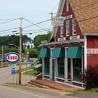
Tyne Valley is a rural municipality in Prince Edward Island, Canada. It is located in Prince County. Incorporated in 1966, the community is located in the township of Lot 13 at the intersection of Routes 12 and 167.

St. Louis is a municipality that holds community status in Prince Edward Island, Canada.

<span class="mw-page-title-main">Charlottetown</span> Capital city of Prince Edward Island, Canada

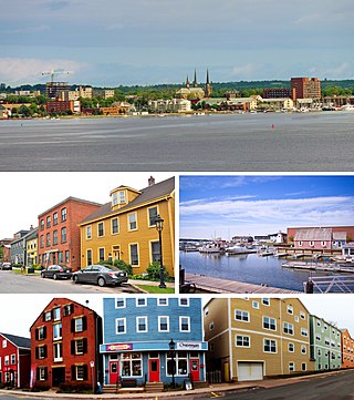
Charlottetown is the capital and largest city of the Canadian province of Prince Edward Island, and the county seat of Queens County. Named after Queen Charlotte, Charlottetown was an unincorporated town until it was incorporated as a city in 1855.

<span class="mw-page-title-main">Cardigan, Prince Edward Island</span> Municipality in Prince Edward Island

Cardigan was a municipality that held community status in Prince Edward Island, Canada. It was a fishing community in eastern Kings County.

Afton is a former rural municipality in the Canadian province of Prince Edward Island within Queens County.

Lady Slipper was a municipality that held community status in Prince Edward Island, Canada. On September 28, 2018, it was combined with the municipality of Ellerslie-Bideford, to create the new municipality of Central Prince.

Grand Tracadie was a municipality that holds community status in Prince Edward Island, Canada. It was incorporated in 1984. The village itself was located in the central portion of Prince Edward Island. On September 28, 2018, it was merged with the municipality of North Shore. Grand Tracadie finds itself partly in a National Park of Canada. It is close to Charlottetown, the cultural hub of P.E.I.

Meadowbank, previously Meadow Bank, is a former rural municipality in the Canadian province of Prince Edward Island within Queens County.

<span class="mw-page-title-main">North Shore, Prince Edward Island</span> Rural municipality in Prince Edward Island, Canada

North Shore is a rural municipality within Queens County in Prince Edward Island that was incorporated on September 28, 2018, through an amalgamation of three municipalities. The municipalities that amalgamated were the rural municipalities of Grand Tracadie, North Shore, and Pleasant Grove.

New Haven-Riverdale is a former rural municipality in the Canadian province of Prince Edward Island within Queens County.

Central Prince is a rural municipality within Prince County in Prince Edward Island that was incorporated on September 28, 2018 through an amalgamation of two municipalities. The municipalities that amalgamated were the rural municipalities of Ellerslie-Bideford and Lady Slipper.

<span class="mw-page-title-main">Rural municipality</span> Index of articles associated with the same name

A rural municipality is a classification of municipality, a type of local government, found in several countries.

References

  1. "Municipal Councils and Contact Information" (PDF). Government of Prince Edward Island. January 27, 2017. Archived from the original (PDF) on December 29, 2016. Retrieved February 4, 2017.
  2. Hamiton, William Baillie (1996). Place Names of Atlantic Canada (illustrated, reprint ed.). University of Toronto Press. ISBN   0802075703 . Retrieved 15 September 2017.
  3. "EC2018585: Municipal Government Act Rural Municipality of Lady Slipper and Rural Municipality of Ellerslie-Bideford Restructuring" (PDF). Government of Prince Edward Island Executive Council. September 25, 2018. pp. 321–323. Retrieved October 27, 2018.