
Canada has a vast geography that occupies much of the continent of North America, sharing land borders with the contiguous United States to the south and the U.S. state of Alaska to the northwest. Canada stretches from the Atlantic Ocean in the east to the Pacific Ocean in the west; to the north lies the Arctic Ocean. Greenland is to the northeast and to the southeast Canada shares a maritime boundary with France's overseas collectivity of Saint Pierre and Miquelon, the last vestige of New France. By total area, Canada is the second-largest country in the world, after Russia. By land area alone, however, Canada ranks fourth, the difference being due to it having the world's largest proportion of fresh water lakes. Of Canada's thirteen provinces and territories, only two are landlocked while the other eleven all directly border one of three oceans.

Newfoundland and Labrador is the easternmost province of Canada, in the country's Atlantic region. It is composed of the island of Newfoundland and the continental region of Labrador to the northwest, with a combined area of 405,212 square kilometres (156,500 sq mi). In 2018, the province's population was estimated at 525,073. About 94% of the province's population lives on the island of Newfoundland, of whom more than half live on the Avalon Peninsula.

Hudson Strait links the Atlantic Ocean and Labrador Sea to Hudson Bay in Canada. This strait lies between Baffin Island and Nunavik, with its eastern entrance marked by Cape Chidley in Newfoundland and Labrador and Resolution Island off Baffin Island. The strait is about 750 km long with an average width of 125 km, varying from 70 km at the eastern entrance to 240 km at Deception Bay.

Ellesmere Island is Canada's northernmost and third largest island, and the tenth largest in the world. It comprises an area of 196,235 km2 (75,767 sq mi), slightly smaller than Great Britain, and the total length of the island is 830 km (520 mi).

The Gulf of St. Lawrence is the outlet of the North American Great Lakes via the St. Lawrence River into the Atlantic Ocean. The gulf is a semi-enclosed sea, covering an area of about 226,000 square kilometres (87,000 sq mi) and containing about 34,500 cubic kilometres (8,300 cu mi) of water, which results in an average depth of 152 metres (499 ft).
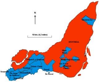
The Island of Montreal, in southwestern Quebec, Canada, is the site of a number of municipalities including most of the city of Montreal and is the most populous island in Canada. It is the main island of the Hochelaga Archipelago at the confluence of the Saint Lawrence and Ottawa rivers.
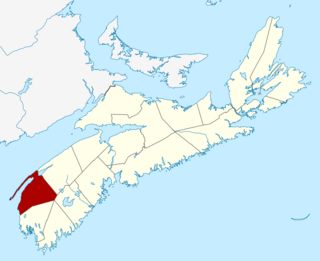
Digby County is a county in the Canadian province of Nova Scotia.
Haldimand County is a rural city-status single-tier municipality on the Niagara Peninsula in Southern Ontario, Canada, on the north shore of Lake Erie, and on the Grand River. Despite its name, it is no longer a county by definition, as all municipal services are handled by a single level of government. Municipal offices are located in Cayuga.

Baffin Bay, located between Baffin Island and the west coast of Greenland, is defined by the International Hydrographic Organization as a marginal sea of the Arctic Ocean. It is sometimes considered a sea of North Atlantic Ocean. It is connected to the Atlantic via Davis Strait and the Labrador Sea. The narrower Nares Strait connects Baffin Bay with the Arctic Ocean. The bay is not navigable most of the year because of the ice cover and high density of floating ice and icebergs in the open areas. However, a polynya of about 80,000 km2 (31,000 sq mi), known as the North Water, opens in summer on the north near Smith Sound. Most of the aquatic life of the bay is concentrated near that region.

The Regional District of Nanaimo is a regional district located on the eastern coast of Vancouver Island, British Columbia, Canada. It is bordered to the south by the Cowichan Valley Regional District, to the west by the Alberni-Clayoquot Regional District, and to the northwest by the Comox Valley Regional District. Its administration offices are located in Nanaimo. During the 2016 census, its population was established at 155,698.
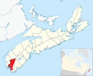
Argyle, officially named the Municipality of the District of Argyle, is a district municipality in Yarmouth County, Nova Scotia. Statistics Canada classifies the district municipality as a municipal district.

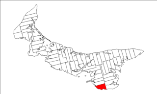
Lot 35 is a township in Queens County, Prince Edward Island, Canada. It is part of Bedford Parish. Lot 35 was awarded to Sir Alexander Maitland, 1st Baronet in the 1767 land lottery. It was sold in 1792 to John MacDonald of Glenaladale.
Lot 62 is a township in Queens County, Prince Edward Island, part of St. John's Parish. Lot 62 was awarded to Richard Spry, Esquire in the 1767 Land Lottery, and came to be settled through the efforts of Thomas Douglas, The 5th Earl of Selkirk in 1803. Richard Spry, Esquire, was then Commodore, Commander-in-Chief, Mediterranean Fleet at Gibraltar 1766–1769. Becoming the proprietor, he would be familiar with then the Island of St. John, having first come out to North America in 1754, with the English naval blockade of Ile Royal and the Fortress of Louisbourg in 1756, and then serving off Quebec and in the St. Lawrence into 1759. In 1762, he returned as Commander-in-Chief, North America, quartered in Halifax.

Lot 39 is a township in Kings County, Prince Edward Island, Canada. It is part of St. Patrick's Parish. Lot 39 was one of four lots awarded to the officers of the 78th Fraser Highlanders in the 1767 land lottery. Col. Thomas Dawson purchased 500 acres (2.0 km2) of land in Lot 39 on March 19, 1800, for 135 pounds, 8 shillings and 4 pence, later adding another 100 acres (0.40 km2). He emigrated from Coote Hill, County Cavan, Ireland with wife Elizabeth and six children, arriving in PEI on June 6, 1801. Col. Thomas Dawson (1762–1804) called his new property Dawson's Grove, after a Dawson family property in Ireland. He is buried at Elm Avenue Cemetery, Charlottetown, PEI.

Hurricane Karen was a hurricane of non-tropical origin that formed in October of the 2001 Atlantic hurricane season. It developed out of the interaction between a cold front and an upper level trough on October 10 located to the south of Bermuda, and quickly strengthened as an extratropical storm. The storm passed near Bermuda on October 12, producing hurricane-force winds on the island. It then organized, becoming a subtropical cyclone on the 12th and a tropical cyclone on the 13th. Karen strengthened to reach 80 mph (130 km/h) winds as a Category 1 hurricane on the Saffir-Simpson Hurricane Scale, and after weakening over cooler waters, it made landfall on Nova Scotia as a tropical storm. It quickly became extratropical.

The raccoon, sometimes called the common raccoon to distinguish it from other species, is a medium-sized mammal native to North America. It is the largest of the procyonid family, having a body length of 40 to 70 cm, and a body weight of 5 to 26 kg. Its grayish coat mostly consists of dense underfur, which insulates it against cold weather. Three of the raccoon's most distinctive features are its extremely dexterous front paws, its facial mask, and its ringed tail, which are themes in the mythologies of the indigenous peoples of the Americas relating to the animal. The raccoon is noted for its intelligence, as studies show that it is able to remember the solution to tasks for at least three years. It is usually nocturnal and omnivorous, eating about 40% invertebrates, 33% plants, and 27% vertebrates.

Kaminia is a village in the northeast of the island of Lemnos, Greece. It is a community of the municipal unit of Moudros. From 1918 until 1998, it was an independent community. The population in 2011 was 234 for the village and 243 for the community, which includes the village Vroskopos. It is located in the southeastern peninsula of the island, 5 km east of Moudros, 6 km northwest of Fisini and 7 km south of Kontopouli. Its elevation is about 60 m. Its area is 12.847 km2, of which 7.60 km2 are arable.

Resort Municipality, officially named the Resort Municipality of Stanley Bridge, Hope River, Bayview, Cavendish and North Rustico, is the lone municipality in Prince Edward Island, Canada that holds resort municipality status. It was established in 1990.
The 2020 Canadian Premier League Final determined the winner of the 2020 Canadian Premier League season. It was played on September 19, 2020, in Charlottetown, Prince Edward Island, between Forge FC, the defending league champion, and HFX Wanderers FC. Those teams qualified as the winner and runner-up of the group stage of The Island Games tournament.
