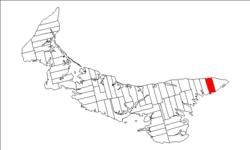
Lot 46, Prince Edward Island

Last updated
Lot 46, Prince Edward Island
Township
Map of Prince Edward Island highlighting Lot 46.png
Map of Prince Edward Island highlighting Lot 46
Coordinates: 46°25′N62°11′W / 46.417°N 62.183°W / 46.417; -62.183 Coordinates: 46°25′N62°11′W / 46.417°N 62.183°W / 46.417; -62.183
Country Canada
Province Prince Edward Island
County Kings County,
Parish East Parish
Area [1]
  Total 32.35 sq mi (83.79 km2)
Population (2006) [1]
  Total 400
  Density 12/sq mi (4.8/km2)
Time zone AST (UTC-4)
  Summer (DST) ADT (UTC-3)
Canadian Postal code C0A
Area code(s) 902
NTS Map 011L08
GNBC Code BAESG

Lot 46 is a township in Kings County, Prince Edward Island, Canada. It is part of East Parish. Lot 46 was awarded to Alexander Fordyce and Robert Gordon in the 1767 land lottery. [2]

Kings County, Prince Edward Island Place

Kings County is located in eastern Prince Edward Island, Canada.
Prince Edward Island Province of Canada

Prince Edward Island is a province of Canada consisting of the Atlantic island of the same name along with several much smaller islands nearby. PEI is one of the three Maritime Provinces. It is the smallest province of Canada in both land area and population, but it is the most densely populated. Part of the traditional lands of the Mi'kmaq, it became a British colony in the 1700s and was federated into Canada as a province in 1873. Its capital is Charlottetown. According to the 2016 census, the province of PEI has 142,907 residents.

Canada Country in North America

Canada is a country in the northern part of North America. Its ten provinces and three territories extend from the Atlantic to the Pacific and northward into the Arctic Ocean, covering 9.98 million square kilometres, making it the world's second-largest country by total area. Canada's southern border with the United States is the world's longest bi-national land border. Its capital is Ottawa, and its three largest metropolitan areas are Toronto, Montreal, and Vancouver. As a whole, Canada is sparsely populated, the majority of its land area being dominated by forest and tundra. Consequently, its population is highly urbanized, with over 80 percent of its inhabitants concentrated in large and medium-sized cities, many near the southern border. Canada's climate varies widely across its vast area, ranging from arctic weather in the north, to hot summers in the southern regions, with four distinct seasons.
Related Research Articles

Stratford, Prince Edward Island Town in Prince Edward Island, Canada

Stratford is a town located in Queens County, Prince Edward Island.

Union Road is a municipality that holds community status in Prince Edward Island, Canada. It is located in Queens County.

Lot 36, Prince Edward Island Township in Prince Edward Island, Canada

Lot 36 is a township in Queens County, Prince Edward Island, Canada. It is part of Bedford Parish. Lot 36 was awarded to merchants George Spence and John Mill in the 1767 land lottery. It was sold to Donald MacDonald in 1775.

Halifax Parish, Prince Edward Island

Halifax Parish was created as a civil parish in Prince County, Prince Edward Island, Canada, during the 1764-1766 survey of Samuel Holland.

Richmond Parish, Prince Edward Island parish in Prince Edward Island, Canada

Richmond Parish was created as a civil parish in Prince County, Prince Edward Island, Canada, during the 1764-1766 survey of Samuel Holland.

St. Davids Parish, Prince Edward Island human settlement

St. David's Parish was created as a civil parish in Prince County, Prince Edward Island, Canada, during the 1764-1766 survey of Samuel Holland.

Bedford Parish, Prince Edward Island

Bedford Parish was created as a civil parish in Queens County, Prince Edward Island, Canada, during the 1764-1766 survey of Samuel Holland.

St. Johns Parish, Prince Edward Island

St. John's Parish was created as a civil parish in Queens County, Prince Edward Island, Canada, during the 1764-1766 survey of Samuel Holland.

St Patricks (civil parish, Prince Edward Island)

St. Patrick's Parish was created as a civil parish in Kings County, Prince Edward Island, Canada, during the 1764-1766 survey of Samuel Holland.

East Parish, Prince Edward Island

East Parish was created as a civil parish in Kings County, Prince Edward Island, Canada, during the 1764-1766 survey of Samuel Holland.

St. Georges Parish, Prince Edward Island

St. George's Parish was created as a civil parish in Kings County, Prince Edward Island, Canada, during the 1764-1766 survey of Samuel Holland.

Prince County, Prince Edward Island Place

Prince County is located in western Prince Edward Island, Canada. The county's defining geographic feature is Malpeque Bay, a sub-basin of the Gulf of St. Lawrence, which creates the narrowest portion of Prince Edward Island's landmass, an isthmus upon which the city of Summerside is located.

Miscouche rural municipality in Prince Edward Island

Miscouche is a municipality that holds community status in Prince Edward Island, Canada. It is located in Prince County.

Belmont is a Canadian rural farming community located in the larger community of Lot 16 in central Prince County, Prince Edward Island. Lot 16 is actually three communities: Belmont, Central, and Southwest Lot 16, and is one of the last communities on Prince Edward Island to continue using their lot designation from the original Island survey by Samuel Holland in the 18th century.

Murray Harbour, Prince Edward Island Community in Prince Edward Island, Canada

Murray Harbour is a municipality that holds rural municipality status in Prince Edward Island, Canada. It is located in southeastern Kings County.

Freeland, Prince Edward Island human settlement in Prince Edward Island, Canada

Freeland is a Canadian rural community in Prince County, Prince Edward Island.

Abram-Village is a Canadian rural municipality located in Prince County, Prince Edward Island.

Crapaud, Prince Edward Island rural municipality in Prince Edward Island

Crapaud is a municipality that holds community status in Prince Edward Island, Canada. It is located north of Victoria in the township of Lot 29.

Tignish Shore, Prince Edward Island

Tignish Shore is a municipality that holds community status in Prince Edward Island, Canada. It is located in the Lot 1 township.

Long River, Prince Edward Island locality in Prince Edward Island

Long River is an unincorporated community, in Queens County. Long River is in Lot 20 of Statistics Canada

References

  1. 1 2 Stats Canada 2001
  2. Clark, Andrew Hill (1959). Three Centuries and the Island. Toronto Press. pp. Appendix B.