
Queens County is a county in the province of Prince Edward Island, Canada. It is the largest county in the province by population with 89,770 (2021) and land. Charlottetown is the county seat of Queens County, and is the largest city and the capital of Prince Edward Island.

The Port River is part of a tidal estuary located north of the Adelaide city centre in the Australian state of South Australia. It has been used as a shipping channel since the beginning of European settlement of South Australia in 1836, when Colonel Light selected the site to use as a port. Before colonisation, the Port River region and the estuary area were known as Yerta Bulti by the Kaurna people, and used extensively as a source of food and plant materials to fashion artefacts used in daily life.

Cavendish is an unincorporated rural community in the township of Lot 23, Queens County, Prince Edward Island, Canada.

Montague is a community within the Town of Three Rivers in Kings County, Prince Edward Island, Canada. Previously incorporated as a town, it amalgamated with the Town of Georgetown, the rural municipalities of Brudenell, Cardigan, Lorne Valley, Lower Montague, and Valleyfield, and portions of three adjacent unincorporated areas in 2018.
Lot 21 is a township in Queens County, Prince Edward Island, Canada. It is part of Greenville Parish. Lot 21 was awarded to Hugh and Lauchlin MacLeane in the 1767 land lottery. Merchant Robert Clark became owner in 1775.

Lot 22 is a township in Queens County, Prince Edward Island, Canada. It is part of Greenville Parish. Lot 22 was awarded to John Gordon and William Ridge in the 1767 land lottery.

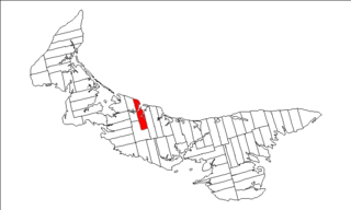
Lot 23 is a township in Queens County, Prince Edward Island, Canada. It is part of Greenville Parish. Lot 23 was awarded to Allan and Lauchlin MacLeane in the 1767 land lottery.

North Rustico is a Canadian town located in Queens County, Prince Edward Island.
Belmont is a Canadian rural farming community located in the larger community of Lot 16 in central Prince County, Prince Edward Island. Lot 16 is actually three communities: Belmont, Central, and Southwest Lot 16, and is one of the last communities on Prince Edward Island to continue using their lot designation from the original Island survey by Samuel Holland in the 18th century.
Oyster River is a small community on Vancouver Island, British Columbia, located between Campbell River and Black Creek mainly along or close to Highway 19A. Located just north of the estuary of the Oyster River, it is home to around 1,500 people and a very small commercial sector.

Rustico-Emerald is a provincial electoral district for the Legislative Assembly of Prince Edward Island, Canada. It was formerly known as Park Corner-Oyster Bed.
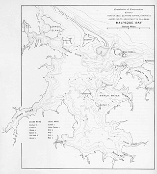
Malpeque Bay is a 204 km2 (79 sq mi) estuarine bay on the north shore of Prince Edward Island, Canada.

Resort Municipality, officially named the Resort Municipality of Stanley Bridge, Hope River, Bayview, Cavendish and North Rustico, is the lone municipality in Prince Edward Island, Canada that holds resort municipality status. It was established in 1990.
A resort municipality is a type of municipal status in the Canadian provinces of British Columbia and Prince Edward Island. British Columbia also has a related municipal status type of mountain resort municipality.

Prince Edward Island Route 6 is a secondary highway in central Prince Edward Island.

Brackley-Hunter River is a provincial electoral district for the Legislative Assembly of Prince Edward Island, Canada. It was created prior to the 2019 election from parts of the former districts West Royalty-Springvale and York-Oyster Bed.

South Rustico, formerly called Rustico, is an unincorporated rural community in the township of Lot 24, Queens County, Prince Edward Island, Canada.
Oyster Bed Bridge is an unincorporated rural community in the township of Lot 24, Queens County, Prince Edward Island, Canada.


