
Stratford is a town located in Queens County, Prince Edward Island.
Summerside is a Canadian city in Prince County, Prince Edward Island. It is the second largest city in the province and the primary service centre for the western part of the island.

Haliburton—Kawartha Lakes—Brock is a federal electoral district in central Ontario, Canada, that has been represented in the House of Commons of Canada since 1968.

The Sunshine Coast Regional District is a regional district in British Columbia, Canada. It is located on the southern mainland coast, across Georgia Strait from Vancouver Island. It borders on the qathet Regional District to the north, the Squamish-Lillooet Regional District to the east, and, across Howe Sound, the Metro Vancouver District to the south. The regional district offices are located in the District Municipality of Sechelt.

Greater Montreal is the most populous metropolitan area in Quebec and the second most populous in Canada after Greater Toronto. In 2015, Statistics Canada identified Montreal's Census Metropolitan Area (CMA) as 4,258.31 square kilometres (1,644.14 sq mi) with a population of 4,027,100, almost half that of the province.

Durham is a federal electoral district in Ontario, Canada, that has been represented in the House of Commons of Canada from 1904 to 1968 and since 1988.

Essex is a federal electoral district in Ontario, Canada, represented in the House of Commons of Canada from 1867 to 1882 and since 1968.
The North Coast Regional District is a quasi-municipal administrative area in British Columbia. It is located on British Columbia's west coast and includes Haida Gwaii, the largest of which are Graham Island and Moresby Island. Its administrative offices are in the City of Prince Rupert.
Welsh Canadians are Canadian citizens of Welsh descent or Wales-born people who reside in Canada.
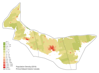
Prince Edward Island is a Canadian province. According to the 2011 National Household Survey, the largest ethnic group consists of people of Scottish descent (39.2%), followed by English (31.1%), Irish (30.4%), French (21.1%), German (5.2%), and Dutch (3.1%) descent. Prince Edward Island is mostly a white community and there are few visible minorities. Chinese people are the largest visible minority group of Prince Edward Island, comprising 1.3% of the province's population. Almost half of respondents identified their ethnicity as "Canadian." Prince Edward Island is by a strong margin the most Celtic and specifically the most Scottish province in Canada and perhaps the most Scottish place (ethnically) in the world, outside Scotland. 38% of islanders claim Scottish ancestry, but this is an underestimate and it is thought that almost 50% of islanders have Scottish roots. When combined with Irish and Welsh, almost 80% of islanders are of some Celtic stock, albeit most families have resided in PEI for at least two centuries. Few places outside Europe can claim such a homogeneous Celtic ethnic background. The only other jurisdiction in North America with such a high percentage of British Isles heritage is Newfoundland.
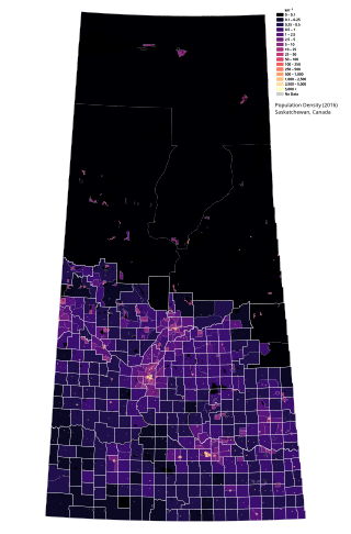
Saskatchewan is the middle province of Canada's three Prairie provinces. It has an area of 651,900 km2 (251,700 mi2) and a population of 1,132,505 (Saskatchewanians) as of 2021. Saskatchewan's population is made of 50.3% women and 49.7% men. Most of its population lives in the Southern half of the province.

Manitoba is one of Canada's 10 provinces. It is the easternmost of the three Prairie provinces.

Newfoundland and Labrador is a province of Canada on the country's Atlantic coast in northeastern North America. The province has an area of 405,212 square kilometres and a population in 2024 of 540,552, with approximately 95% of the provincial population residing on the Island of Newfoundland, with more than half of the population residing on the Avalon Peninsula. People from Newfoundland and Labrador are called "Newfoundlanders," "Labradorians", or "Newfoundlanders and Labradorians".

New Brunswick is one of Canada's three Maritime provinces and the only officially bilingual province in the country. The provincial Department of Finance estimates that the province's population in 2006 was 729,997 of which the majority is English-speaking but with a substantial French-speaking minority of mostly Acadian origin.
The Northwest Territories is a territory of Canada. It has an area of 1,171,918 square kilometres and a population of 41,786 as of the 2016 Canadian census.
Yukon is the westernmost of Canada's three northern territories. Its capital is Whitehorse. People from Yukon are known as Yukoners. Unlike in other Canadian provinces and territories, Statistics Canada uses the entire territory as a single at-large census division.
British Canadians primarily refers to Canadians who were either born in or can trace their ancestry to the British Isles, which includes the nations of England, Ireland, Scotland, Wales, and Northern Ireland.
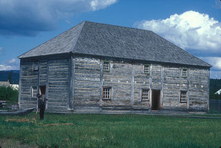
Fort St. James is a district municipality and former fur trading post in northern central British Columbia, Canada. It is located on the south-eastern shore of Stuart Lake in the Omineca Country, at the northern terminus of Highway 27, which connects to Highway 16 at Vanderhoof.
Belgian Canadians are Canadian citizens of Belgian ancestry or Belgium-born people who reside in Canada. According to the 2011 census there were 176,615 Canadians who claimed full or partial Belgian ancestry. It encompasses immigrants from both French and Dutch-speaking parts of Belgium.

In the 2021 Census, the City of Calgary had a population of 1,306,784 residents, representing 30.7% of the 4,262,635 residents in all of Alberta, and 3.5% compared to a population of 36,991,981 in all of Canada. The total population of the Calgary census metropolitan area (CMA) was 1,481,806. Calgary is the largest city in Alberta, and the third-largest municipality and fifth-largest metropolitan area in Canada, as of 2021.
