
The Gulf of St. Lawrence is the outlet of the North American Great Lakes via the St. Lawrence River into the Atlantic Ocean. The gulf is a semi-enclosed sea, covering an area of about 226,000 square kilometres (87,000 sq mi) and containing about 34,500 cubic kilometres (8,300 cu mi) of water, which results in an average depth of 152 metres (499 ft).

The Arctic Archipelago, also known as the Canadian Arctic Archipelago, is an archipelago lying to the north of the Canadian continental mainland, excluding Greenland.

Greater Montreal is the most populous metropolitan area in Quebec and the second most populous in Canada after Greater Toronto. In 2015, Statistics Canada identified Montreal's Census Metropolitan Area (CMA) as 4,258.31 square kilometres (1,644.14 sq mi) with a population of 4,027,100.
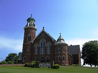
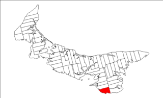
Souris is a town in Kings County, Prince Edward Island, Canada. It is located near the northeastern tip of the province.
Lot 62 is a township in Queens County, Prince Edward Island, part of St. John's Parish. Lot 62 was awarded to Richard Spry, Esquire in the 1767 Land Lottery, and came to be settled through the efforts of Thomas Douglas, The 5th Earl of Selkirk in 1803. Richard Spry, Esquire, was then Commodore, Commander-in-Chief, Mediterranean Fleet at Gibraltar 1766–1769. Becoming the proprietor, he would be familiar with then the Island of St. John, having first come out to North America in 1754, with the English naval blockade of Ile Royal and the Fortress of Louisbourg in 1756, and then serving off Quebec and in the St. Lawrence into 1759. In 1762, he returned as Commander-in-Chief, North America, quartered in Halifax.

Lot 41 is a township in Kings County, Prince Edward Island, Canada. It is part of St. Patrick's Parish. Lot 41 was one of four lots awarded to the officers of the 78th Fraser Highlanders in the 1767 land lottery.

Lot 42 is a township in Kings County, Prince Edward Island, Canada. It is part of St. Patrick's Parish. Lot 42 was one of four lots awarded to the officers of the 78th Fraser Highlanders in the 1767 land lottery.

Egmont Parish was created as a civil parish in Prince County, Prince Edward Island, Canada, during the 1764-1766 survey of Samuel Holland.

East Parish was created as a civil parish in Kings County, Prince Edward Island, Canada, during the 1764-1766 survey of Samuel Holland.

Prince County is located in western Prince Edward Island, Canada. The county's defining geographic feature is Malpeque Bay, a sub-basin of the Gulf of St. Lawrence, which creates the narrowest portion of Prince Edward Island's landmass, an isthmus upon which the city of Summerside is located.

The 45th parallel north is a circle of latitude that is 45 degrees north of Earth's equator. It crosses Europe, Asia, the Pacific Ocean, North America, and the Atlantic Ocean. The 45th parallel north is often called the halfway point between the equator and the North Pole, but the true halfway point is 16.0 km (9.9 mi) north of it because Earth is an oblate spheroid; that is, it bulges at the equator and is flattened at the poles.

Wood Islands is a rural farming and fishing community located in southeastern Queens County, Prince Edward Island on the Northumberland Strait. It takes its name from several small forested islands, then located several hundred metres offshore in the Northumberland Strait. The community of Wood Islands falls within the larger PEI Township of Lot 62, which had a population in 2011 of 470 residents, a 13% decrease from the 2006 census count of 540. While the named islands are located on maps by Jacques-Nicolas Bellin: Karte Bellin, 1744: 'I a Bova' and Louis Franquet: Cartes Franquet, 1751: 'Isle a Bois', it was Samuel Johannes Holland who correctly surveyed and depicted the islands, about their basin. The 'European' settlement of Wood Islands began in 1803, but saw its most noted arrivals in 1807 with the arrival, after wintering in Pinette, of a large party of Scottish settlers from the Spencer.

Tyne Valley is a municipality that holds community status in Prince Edward Island, Canada. It is located in Prince County. Incorporated in 1966, the community is located in the township of Lot 13 at the intersection of Routes 12 and 167.

Helena Island is one of the uninhabited Canadian Arctic islands in the Qikiqtaaluk Region of Nunavut, Canada. It is along the northern coast of Bathurst Island, separated by Sir William Parker Strait. Seymour Island is located off its west coast. Located at 76°39'N 101°04'W, Helena Island is 327 km2 (126 sq mi) in area and measures 41 by 12.8 km.

Grenville Parish was created as a civil parish in Queens County, Prince Edward Island, Canada, during the 1764-1766 survey of Samuel Holland.
San San is a town in the parish of Portland in Jamaica.
The Municipality of Lot 11 and Area is a municipality that holds community status in Prince Edward Island, Canada. It is located within Prince County.

Resort Municipality, officially named the Resort Municipality of Stanley Bridge, Hope River, Bayview, Cavendish and North Rustico, is the lone municipality in Prince Edward Island, Canada that holds resort municipality status. It was established in 1990.
Long River is an unincorporated community, in Queens County. Long River is in Lot 20 of Statistics Canada
