Stratford is a town located in Queens County, Prince Edward Island.

Comox is a town on the southern coast of the Comox Peninsula in the Strait of Georgia on the eastern coast of Vancouver Island, British Columbia. Thousands of years ago, the warm dry summers, mild winters, fertile soil, and abundant sea life attracted First Nations, who called the area kw'umuxws.
Central Bedeque is a former municipality that previously held community status in the Canadian province of Prince Edward Island. It was dissolved through its amalgamation with the Community of Bedeque on November 17, 2014, to create the Community of Bedeque and Area. It is located north of Borden-Carleton within Lot 26, Prince County. Its primary industry is agriculture.

Powell River is a city on the northern Sunshine Coast of southwestern British Columbia, Canada. Most of its population lives near the eastern shores of Malaspina Strait, which is part of the larger Georgia Strait between Vancouver Island and the Mainland. With two intervening long, steep-sided fjords inhibiting the construction of a contiguous road connection with Vancouver to the south, geographical surroundings explain Powell River's remoteness as a community, despite relative proximity to Vancouver and other populous areas of the BC Coast. The city is the location of the head office of the qathet Regional District.
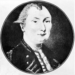
Samuel Johannes Holland was a Dutch-born Royal Engineer and first Surveyor General of British North America.

Courtenay is a city of about 26,000 on the east coast of Vancouver Island, in the Canadian province of British Columbia. It is the largest community and only city in the area commonly known as the Comox Valley, and the seat of the Comox Valley Regional District, which replaced the Comox-Strathcona Regional District. Courtenay is 4 km (2.5 mi) west of the town of Comox, 7 km (4.3 mi) northeast of the village of Cumberland, 5 km (3.1 mi) northwest of the unincorporated settlement of Royston, and 108 km (67 mi) northwest of Nanaimo. Along with Nanaimo and Victoria, it is home to The Canadian Scottish Regiment, a Primary Reserve infantry regiment of the Canadian Armed Forces.

Montague is a community within the Town of Three Rivers in Kings County, Prince Edward Island, Canada. Previously incorporated as a town, it amalgamated with the Town of Georgetown, the rural municipalities of Brudenell, Cardigan, Lorne Valley, Lower Montague, and Valleyfield, and portions of three adjacent unincorporated areas in 2018.
Souris is a town in Kings County, Prince Edward Island, Canada. It is located near the northeastern tip of the province.
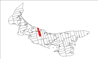
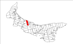
Lot 21 is a township in Queens County, Prince Edward Island, Canada. It is part of Greenville Parish. Lot 21 was awarded to Hugh and Lauchlin MacLeane in the 1767 land lottery. Merchant Robert Clark became owner in 1775.

Lot 22 is a township in Queens County, Prince Edward Island, Canada. It is part of Greenville Parish. Lot 22 was awarded to John Gordon and William Ridge in the 1767 land lottery.

Lot 23 is a township in Queens County, Prince Edward Island, Canada. It is part of Greenville Parish. Lot 23 was awarded to Allan and Lauchlin MacLeane in the 1767 land lottery.
Lot 62 is a township in Queens County, Prince Edward Island, part of St. John's Parish. Lot 62 was awarded to Richard Spry, Esquire in the 1767 Land Lottery, and came to be settled through the efforts of Thomas Douglas, The 5th Earl of Selkirk in 1803. Richard Spry, Esquire, was then Commodore, Commander-in-Chief, Mediterranean Fleet at Gibraltar 1766–1769. Becoming the proprietor, he would be familiar with then the Island of St. John, having first come out to North America in 1754, with the English naval blockade of Ile Royal and the Fortress of Louisbourg in 1756, and then serving off Quebec and in the St. Lawrence into 1759. In 1762, he returned as Commander-in-Chief, North America, quartered in Halifax.

Miscouche is a municipality that holds community status in Prince Edward Island, Canada. It is located in Prince County.
Tyne Valley is a rural municipality in Prince Edward Island, Canada. It is located in Prince County. Incorporated in 1966, the community is located in the township of Lot 13 at the intersection of Routes 12 and 167.

Frontenac Islands is a township located in Frontenac County, Ontario, Canada, that encompasses a number of islands at the beginning of the Saint Lawrence River near the outlet of Lake Ontario, including: Arabella, Bayfield, Black Ant, Garden, Goose, Hickory, Horseshoe, Howe, Wolfe, and Simcoe.
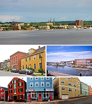
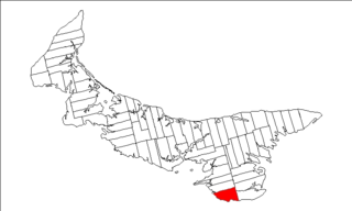
Charlottetown is the capital and largest city of the Canadian province of Prince Edward Island, and the county seat of Queens County. Named after Queen Charlotte, Charlottetown was an unincorporated town until it was incorporated as a city in 1855.
The Municipality of Malpeque Bay is a municipality that holds community status in Prince Edward Island, Canada. It is located in Prince County and Queens County.
The Municipality of Lot 11 and Area is a municipality that holds community status in Prince Edward Island, Canada. It is located within Prince County.

Resort Municipality, officially named the Resort Municipality of Stanley Bridge, Hope River, Bayview, Cavendish and North Rustico, is the lone municipality in Prince Edward Island, Canada that holds resort municipality status. It was established in 1990.
Long River is an unincorporated community, in Queens County. Long River is in Lot 20 of Statistics Canada